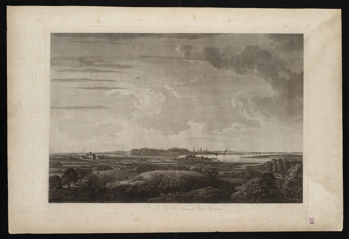
A view of Boston taken on the road to Dorchester
This map is also available in American Revolutionary Geographies Online (ARGO), a collections portal especially built for material relating to the American Revolutionary War Era. Visit ARGO to learn more about this item and explore the historical geography of North America in the late eighteenth century.
Item Information
- Title:
- A view of Boston taken on the road to Dorchester
- Description:
-
We Are One: This 1776 landscape scene, published in the maritime atlas The Atlantic Neptune, depicts Boston as it appeared to a person approaching the town from the south. Shepherds tend their flocks in the foreground, while the Shawmut Peninsula rises from the marshy flats in the background. Numerous church spires and the "beacon" on Beacon Hill are clearly visible on Boston’s skyline. Despite being an important trading port and one of the most populous cities in America, colonial Boston was small compared to a metropolis like London. Boston appears as a little coastal town surrounded by a vast wilderness.
- Creator:
- Newton, James, 1748-ca. 1804
- Name on Item:
-
drawn by Wm. Pierrie ; engrav'd by James Newton.
- Date:
-
1776
- Format:
-
Maps/Atlases
- Location:
-
Boston Public Library
Norman B. Leventhal Map & Education Center - Collection (local):
-
Norman B. Leventhal Map & Education Center Collection
- Subjects:
-
Boston (Mass.)--Pictorial works--Early works to 1800
Boston Harbor (Mass.)--Pictorial works--Early works to 1800
Roxbury (Boston, Mass.)--Pictorial works--Early works to 1800
Shirley, William, 1694-1771
Eustis, William, 1753-1825
- Places:
-
MassachusettsBoston Harbor
MassachusettsSuffolk (county)BostonRoxbury
- Extent:
- 1 view : aquatint, hand-colored ; 42 x 63 cm.
- Terms of Use:
-
No known copyright restrictions.
No known restrictions on use.
- Publisher:
-
[London] :
Published according to an Act of Parliament by J.F.W. Des Barres
- Language:
-
English
- Notes:
-
A view of Roxbury, Boston Harbor, and Boston, Mass. taken from a vantage point in Roxbury or Dorchester. The city of Boston and Boston Harbor are shown in the distance. The Shirley-Eustis house, the home of Governor William Shirley and later Governor William Eustis, in Roxbury is visible in the middle ground.
From J.F.W. Des Barres' Atlantic Neptune.
- Notes (exhibitions):
-
Exhibited: "We Are One: Mapping America's Road from Revolution to Independence" organized by the Norman B. Leventhal Map Center at the Boston Public Library, 2015.
- Identifier:
-
06_01_004514
- Call #:
-
G1106.P5 D47 1781
- Barcode:
-
30000003818422