Toggle navigation
LMEC Home
Exhibitions
Georeferencing
Tools for Teachers
Collections
My Favorites
Sign Up / Log In
Search
Search the map portal
Map Collection
Map Collection
Map Sets
Search
Search
Search for
Search In
All Fields
Creator
Title
Subject
Place
Search All Digital Collections
Advanced Search
8764 Results
My Search
Start Over
More Like
commonwealth:6t053p90c
Remove constraint More Like: commonwealth:6t053p90c
Filter your Search
Place
North and Central America
5,995
United States
4,909
Massachusetts
2,086
Europe
1,396
Suffolk (county)
1,046
Boston
1,019
Canada
458
Asia
438
more
Place
»
Topic
Boston (Mass.)--Maps
586
United States--Maps
282
Real property--Massachusetts--Boston--Maps
175
Massachusetts--Maps
162
Landowners--Massachusetts--Boston--Maps
133
North America--Maps--Early works to 1800
106
New England--Maps
102
New England--Maps--Early works to 1800
97
more
Topic
»
Date
Date range begin
–
Date range end
Current results range from
1482
to
2023
View distribution
Creator
United States. Hydrographic Office
595
O.H. Bailey & Co
148
Des Barres, Joseph F. W. (Joseph Frederick Wallet), 1722-1824
123
United States. Post Office Dept
120
Ptolemy, 2nd cent
100
Walling, Henry Francis, 1825-1888
94
Jefferys, Thomas, -1771
89
Geological Survey (U.S.)
86
more
Creator
»
Format
Maps/Atlases
8,704
Manuscripts
216
Prints
56
Books
36
Objects/Artifacts
10
Drawings/Illustrations
8
Posters
5
Georeferenced
Yes
874
No
7,890
Collection
Norman B. Leventhal Map & Education Center Collection
8,719
Boston and New England Maps
2,245
Urban Maps
2,023
Maritime Charts and Atlases
1,086
American Revolutionary War-Era Maps
653
Boston Redevelopment Authority Collection
87
Mapping Boston Collection
23
Sidney R. Knafel Map Collection at Phillips Academy
15
more
Collection
»
Available to use
No known restrictions
8,555
Creative Commons license
86
Search Constraints
Sort by relevance
relevance
title
date (asc)
date (desc)
Number of results to display per page
20 per page
10
per page
20
per page
50
per page
100
per page
View results as:
grid view
map view
Search Results
61.
Chart for the journal of Mr. le Mquis. de Chastellux
62.
A chart of the coast of America from New found Land to Cape Cod
63.
A chart of the province of New England, with the soundings on the coast; drawn about 1670, on a scale of 1 2/3 English league...
64.
An exact map of New England, New York, Pensylvania & New Jersey, from the latest surveys
65.
Karte von dem Ostlichen-Stucke von Neu Franckreich oder Canada in America : besonders aber Acadia und Neu Schottland
66.
Karte von Neu England, Neu Yorck und Pensilvanien
67.
A map of New England and New York
68.
A map of New England, New York, New Jersey and Pensilvania
69.
A map of New-England, being the first that ever was here cut, and done by the best pattern that could be had, which being in...
70.
A map of New-England, being the first that ever was here cut, and done by the best pattern that could be had, which being in...
71.
A map of New-England, being the first that ever was here cut, and done by the best pattern that could be had, which being in...
72.
A map of the coast of New England, from Staten Island to the island of Breton
73.
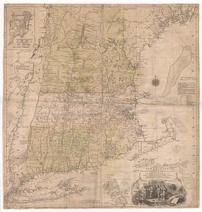
A map of the most inhabited part of New England : containing the provinces of Massachusets Bay and New Hampshire, with the...
74.
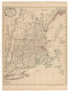
A map of the most inhabited part of New England : containing the provinces of Massachusets Bay and New Hampshire, with the...
75.
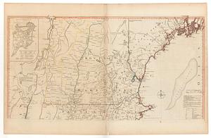
A map of the most inhabited part of New England, containing the provinces of Massachusets Bay and New Hampshire, with the...
76.
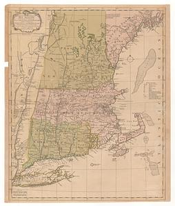
A map of the most inhabited part of New England, containing the provinces of Massachusets Bay and New Hampshire, with the...
77.
A map of the most inhabited part of New England, containing the provinces of Massachusets Bay and New Hampshire, with the...
78.
A map of the most inhabited part of New England, containing the provinces of Massachusetts Bay and New Hampshire, with the...
79.
Map of the northern, or, New England states of America, comprehending Vermont, New Hampshire, District of Main, Massachusetts,...
80.
A map of the Province of New York, with part of Pensilvania, and New England : from an actual survey by Captain Montresor,...
‹ Prev
Next ›
1
2
3
4
5
6
7
8
…
438
439