Toggle navigation
LMEC Home
Exhibitions
Georeferencing
Tools for Teachers
Collections
My Favorites
Sign Up / Log In
Search
Search the map portal
Map Collection
Map Collection
Map Sets
Search
Search
Search for
Search In
All Fields
Creator
Title
Subject
Place
Search All Digital Collections
Advanced Search
8702 Results
My Search
Start Over
More Like
commonwealth:6t053p804
Remove constraint More Like: commonwealth:6t053p804
Filter your Search
Place
North and Central America
5,933
United States
4,846
Massachusetts
2,078
Europe
1,396
Suffolk (county)
1,045
Boston
1,018
Canada
449
Asia
438
more
Place
»
Topic
Boston (Mass.)--Maps
586
United States--Maps
282
Real property--Massachusetts--Boston--Maps
175
Massachusetts--Maps
162
Landowners--Massachusetts--Boston--Maps
133
North America--Maps--Early works to 1800
103
New England--Maps
102
Europe--Maps
79
more
Topic
»
Date
Date range begin
–
Date range end
Current results range from
1482
to
2023
View distribution
Creator
United States. Hydrographic Office
595
O.H. Bailey & Co
148
Des Barres, Joseph F. W. (Joseph Frederick Wallet), 1722-1824
124
United States. Post Office Dept
120
Ptolemy, 2nd cent
100
Walling, Henry Francis, 1825-1888
94
Geological Survey (U.S.)
86
Jefferys, Thomas, -1771
85
more
Creator
»
Format
Maps/Atlases
8,642
Manuscripts
216
Prints
56
Books
36
Objects/Artifacts
10
Drawings/Illustrations
8
Posters
5
Georeferenced
Yes
869
No
7,833
Collection
Norman B. Leventhal Map & Education Center Collection
8,693
Boston and New England Maps
2,232
Urban Maps
2,023
Maritime Charts and Atlases
1,083
American Revolutionary War-Era Maps
623
Boston Redevelopment Authority Collection
87
MacLean Collection Map Library
3
Richard H. Brown Revolutionary War Map Collection at Mount Vernon
3
more
Collection
»
Available to use
No known restrictions
8,551
Creative Commons license
53
Search Constraints
Sort by relevance
relevance
title
date (asc)
date (desc)
Number of results to display per page
20 per page
10
per page
20
per page
50
per page
100
per page
View results as:
grid view
map view
Search Results
1.
Carte de la Virginie, du Maryland et de l'etat de Delaware
2.
Carte de la Virginie et du Maryland
3.
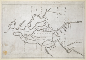
A New map of the province of Maryland in North America
4.
The states of Maryland and Delaware, from the latest surveys
5.
Carte de la Baye et Riviere de Délaware : contenant une éxacte et entiére description des rivages, criques, havres, sondes,...
6.
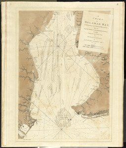
A chart of Delaware Bay and River, containing a full and exact description of the shores, creeks, harbours, soundings, shoals,...
7.
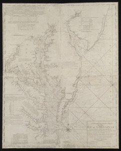
A new and accurate chart of the Bay of Chesapeak including Delaware Bay with all the shoals, channels, islands, entrances,...
8.
A new and accurate chart of the Bay of Chesapeak including Delaware Bay with all the shoals, channels, islands, entrances,...
9.
A new and accurate chart of the Bay of Chesapeak including Delaware Bay with all the shoals, channels, islands, entrances,...
10.
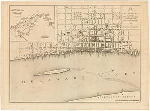
A plan of the city of Philadelphia, the capital of Pennsylvania, from an actual survey
11.
Virginia, Maryland, Pennsilvania, east & west New Jarsey
12.
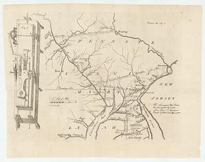
[A map of part of Pennsylvania & Maryland intended to shew, at one view, the several places proposed for opening a...
13.
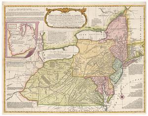
A general map of the Middle British Colonies in America viz. Virginia, Maryland, Delaware, Pensilvania, New-Jersey New York,...
14.
Map of part of Pennsylvania & Maryland intended to illustrate proposals for a communication between the waters of the Delaware...
15.
A map of that part of America where a degree of latitude was measured for the Royal Society
16.
PLAN OF THE PENINSULA OF CHESOPEAK BAY
17.
Proposed Maryland / Pennsylvania Boundary
18.
A chart of Delawar Bay, with soundings and nautical observations
19.
A plan of the city of Philadelphia, the capital of Pennsylvania, from an actual survey
20.
A plan of the city of Philadelphia, the capital of Pennsylvania, from an actual survey
‹ Prev
Next ›
1
2
3
4
5
…
435
436


![[A map of part of Pennsylvania & Maryland intended to shew, at one view, the several places proposed for opening a communication between the waters of the Delaware & Chesopeak Bays]](https://bpldcassets.blob.core.windows.net/derivatives/images/commonwealth:z603vt12v/image_thumbnail_300.jpg)