Toggle navigation
LMEC Home
Exhibitions
Georeferencing
Tools for Teachers
Collections
My Favorites
Sign Up / Log In
Search
Search the map portal
Map Collection
Map Collection
Map Sets
Search
Search
Search for
Search In
All Fields
Creator
Title
Subject
Place
Search All Digital Collections
Advanced Search
8775 Results
My Search
Start Over
More Like
commonwealth:6t053p17c
Remove constraint More Like: commonwealth:6t053p17c
Filter your Search
Place
North and Central America
6,006
United States
4,916
Massachusetts
2,092
Europe
1,396
Suffolk (county)
1,048
Boston
1,021
Canada
458
Asia
438
more
Place
»
Topic
Boston (Mass.)--Maps
587
United States--Maps
282
Real property--Massachusetts--Boston--Maps
175
Massachusetts--Maps
162
Landowners--Massachusetts--Boston--Maps
133
North America--Maps--Early works to 1800
106
New England--Maps
102
New England--Maps--Early works to 1800
97
more
Topic
»
Date
Date range begin
–
Date range end
Current results range from
1482
to
2023
View distribution
Creator
United States. Hydrographic Office
595
O.H. Bailey & Co
148
Des Barres, Joseph F. W. (Joseph Frederick Wallet), 1722-1824
123
United States. Post Office Dept
120
Ptolemy, 2nd cent
100
Walling, Henry Francis, 1825-1888
94
Jefferys, Thomas, -1771
88
Geological Survey (U.S.)
86
more
Creator
»
Format
Maps/Atlases
8,715
Manuscripts
218
Prints
56
Books
36
Objects/Artifacts
10
Drawings/Illustrations
8
Posters
5
Georeferenced
Yes
876
No
7,899
Collection
Norman B. Leventhal Map & Education Center Collection
8,720
Boston and New England Maps
2,246
Urban Maps
2,023
Maritime Charts and Atlases
1,086
American Revolutionary War-Era Maps
664
Boston Redevelopment Authority Collection
87
Mapping Boston Collection
24
Sidney R. Knafel Map Collection at Phillips Academy
20
more
Collection
»
Available to use
No known restrictions
8,555
Creative Commons license
92
Search Constraints
Sort by relevance
relevance
title
date (asc)
date (desc)
Number of results to display per page
20 per page
10
per page
20
per page
50
per page
100
per page
View results as:
grid view
map view
Search Results
1201.
Carta particolare della parte ocidentale della nuova Spagnia, è del la California
1202.
Carta particolare della terra nuoua con la Gran Baia et il Fiume Grande della Canida
1203.
Carta particolare dell'India Ocidentale, con la terra ferma dal' capo di Paria sin al' capo S. Romano
1204.
Carta particolare dell'Isola Ispaniola è S. Gioni. nel'India ocidentle. con l'Isola Intorno
1205.
Carta particolare dell'Isole Fillipine è di Luzon : la longitune. cominca. de l'Isola di Pico d'Asores : d'Asia carta X
1206.
Carta particolare dello istreto e mare iscoperto de Hen. Hudson Ingilese nel. 1611
1207.
Carta particolare dello stretto di Iezo fra l'America è l'isola Iezo
1208.
Carta particolare dello Stretto di Magellano è di Maire
1209.
Carta statistica e postale dell'Italia
1210.
Carta topografica della provincia di Roma e regioni limitrofe con cartina speciale dei Colli Albani secondo i recenti rilievi...
1211.
Carta topografica dell'antichità di Roma : la quale esattamente contiene tutte le vestigie delle antiche fabriche, e monumenti...
1212.
Carta universal en que se contiene todo lo que del mundo se ha descubierto fasta agora
1213.
Carta universal en que se contiene todo lo que del mundo se ha descubierto fasta agora
1214.
Carte chorographique des Pays-Bas Autrichiens
1215.
Carte d'Amerique : dressée pour l'usage du roy
1216.
Carte d'Amerique : dressée pour l'usage du Roy
1217.
Carte d'Amerique divisées en ses principales parties
1218.
Carte de Canada, de la Nouvelle Ecosse et de l'Acadie : d'après les originaux Anglais
1219.
Carte de da partie européenne de l'empire de Russie : avec l'indication des chemins de poste, ainsi que des douanes...
1220.
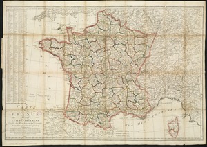
Carte de France divisée en 86 departemens
‹ Prev
Next ›
1
2
…
57
58
59
60
61
62
63
64
65
…
438
439