Toggle navigation
LMEC Home
Exhibitions
Georeferencing
Tools for Teachers
Collections
My Favorites
Sign Up / Log In
Search
Search the map portal
Map Collection
Map Collection
Map Sets
Search
Search
Search for
Search In
All Fields
Creator
Title
Subject
Place
Search All Digital Collections
Advanced Search
8730 Results
My Search
Start Over
More Like
commonwealth:4m90f361w
Remove constraint More Like: commonwealth:4m90f361w
Filter your Search
Place
North and Central America
5,961
United States
4,879
Massachusetts
2,079
Europe
1,396
Suffolk (county)
1,047
Boston
1,020
Canada
450
Asia
438
more
Place
»
Topic
Boston (Mass.)--Maps
587
United States--Maps
282
Real property--Massachusetts--Boston--Maps
175
Massachusetts--Maps
162
Landowners--Massachusetts--Boston--Maps
133
North America--Maps--Early works to 1800
103
New England--Maps
102
Europe--Maps
79
more
Topic
»
Date
Date range begin
–
Date range end
Current results range from
1482
to
2023
View distribution
Creator
United States. Hydrographic Office
595
O.H. Bailey & Co
148
Des Barres, Joseph F. W. (Joseph Frederick Wallet), 1722-1824
123
United States. Post Office Dept
120
Ptolemy, 2nd cent
100
Walling, Henry Francis, 1825-1888
94
Geological Survey (U.S.)
86
Jefferys, Thomas, -1771
85
more
Creator
»
Format
Maps/Atlases
8,670
Manuscripts
217
Prints
56
Books
36
Objects/Artifacts
10
Drawings/Illustrations
8
Posters
5
Georeferenced
Yes
869
No
7,861
Collection
Norman B. Leventhal Map & Education Center Collection
8,694
Boston and New England Maps
2,233
Urban Maps
2,023
Maritime Charts and Atlases
1,083
American Revolutionary War-Era Maps
650
Boston Redevelopment Authority Collection
87
William L. Clements Library Collection
27
American Antiquarian Society Collection
4
more
Collection
»
Available to use
No known restrictions
8,555
Creative Commons license
48
Search Constraints
Sort by relevance
relevance
title
date (asc)
date (desc)
Number of results to display per page
20 per page
10
per page
20
per page
50
per page
100
per page
View results as:
grid view
map view
Search Results
7361.
Sheboygan County, Wis.
7362.
Shepherd's map of the seat of war
7363.
Sherman & Smith's rail road, steam boat & stage route map of New England, New-York, and Canada
7364.
Shewey's new map of the city of St. Louis
7365.
Shíjú tú
7366.
Shipyard Park phase 3 : Boston Naval Shipyard at Charlestown : schematic design
7367.
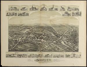
Shirley, Massachusetts, 1892
7368.
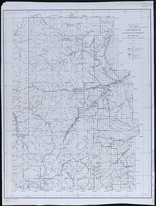
Shoshone National Forest, Wyoming
7369.
Showing rental values in greater Tokyo - 1926
7370.
Siberia
7371.
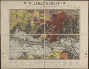
Das Siebengebirge
7372.
The siege of Colberg, from 3d. to 31st. October, 1758
7373.
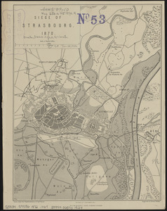
Siege of Strasbourg, 1870
7374.
Siege of Strasbourg, 1870 : enlarged sketch of works
7375.
Siege of Vera Cruz, by the U.S. troops under Major General Scott, in March 1847, from surveys made by Major Turnbull, Captains...
7376.
Siege operations at Spanish Fort, Mobile Bay : by the U.S. forces under Maj. Gen. Canby. Captured by the Army of West Miss. on...
7377.
Simoda Harbor, I. of Nippon
7378.
Siskiyou National Forest, Oregon and California
7379.
Site preparation contract for the reconstruction of Copley Square Park, City of Boston, Massachusetts : contract documents
7380.
Site preparation contract tree planting - various locations
‹ Prev
Next ›
1
2
…
365
366
367
368
369
370
371
372
373
…
436
437