Toggle navigation
LMEC Home
Exhibitions
Georeferencing
Tools for Teachers
Collections
My Favorites
Sign Up / Log In
Search
Search the map portal
Map Collection
Map Collection
Map Sets
Search
Search
Search for
Search In
All Fields
Creator
Title
Subject
Place
Search All Digital Collections
Advanced Search
8357 Results
My Search
Start Over
More Like
commonwealth:3f463689d
Remove constraint More Like: commonwealth:3f463689d
Filter your Search
Place
North and Central America
5,106
United States
3,794
Suffolk (county)
1,216
Boston
1,189
Europe
963
Canada
427
Massachusetts
275
France
269
more
Place
»
Topic
Boston (Mass.)--Maps
740
United States--Maps
270
Real property--Massachusetts--Boston--Maps
222
Landowners--Massachusetts--Boston--Maps
168
Massachusetts--Maps
163
City planning--Massachusetts--Boston--Maps
156
North America--Maps--Early works to 1800
103
New England--Maps
101
more
Topic
»
Date
Date range begin
–
Date range end
Current results range from
1482
to
2023
View distribution
Creator
United States. Hydrographic Office
357
Boston Redevelopment Authority
161
O.H. Bailey & Co
148
Des Barres, Joseph F. W. (Joseph Frederick Wallet), 1722-1824
124
United States. Post Office Dept
120
Ptolemy, 2nd cent
100
Walling, Henry Francis, 1825-1888
94
Bromley, George Washington
86
more
Creator
»
Format
Maps/Atlases
8,298
Manuscripts
215
Prints
51
Books
36
Objects/Artifacts
10
Drawings/Illustrations
8
Posters
4
Georeferenced
Yes
885
No
7,472
Collection
Norman B. Leventhal Map Center Collection
8,191
Boston and New England Maps
2,310
Urban Maps
2,045
Maritime Charts and Atlases
750
American Revolutionary War-Era Maps
638
Boston Redevelopment Authority Collection
192
Massachusetts Real Estate Atlases
38
Mapping Boston Collection
20
more
Collection
»
Available to use
No known restrictions
8,135
Creative Commons license
69
Search Constraints
Sort by date (asc)
relevance
title
date (asc)
date (desc)
Number of results to display per page
20 per page
10
per page
20
per page
50
per page
100
per page
View results as:
grid view
map view
Search Results
7561.
Route map of Massachusetts
7562.
Tri-state power map : Pennsylvania -- New York -- New Jersey
7563.
Washakie National Forest, Wyoming
7564.
Atlas of the town of Brookline, Norfolk County, Massachusetts : from actual surveys and official plans
7565.
Bern
7566.
Boston and surroundings
7567.
Cape Ann and the North Shore : a map displaying the hardy maritime development of these historic parts
7568.
Elihu Geer Sons new map of East Hartford, Connecticut
7569.
Flathead National Forest, Montana
7570.
Grand Mesa National Forest, Colorado
7571.
Hagstrom's map of Brooklyn (New York City) : house-number and subway guide
7572.
Holy Cross National Forest, Colorado
7573.
Map of Alaska
7574.
A map of Honolulu and the Sandwich Islands which we now call the Hawaiian Islands
7575.
The map of pioneer Hartford : founded 1636, incorporated 1784, showing early landmarks and the locations of historical events
7576.
Map of the Boston Elevated Ry. 1927
7577.
Map of the Canadian Rockies triangle tour of British Columbia, Alaska and the Yukon
7578.
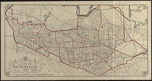
Map of the city of Somerville 1927
7579.
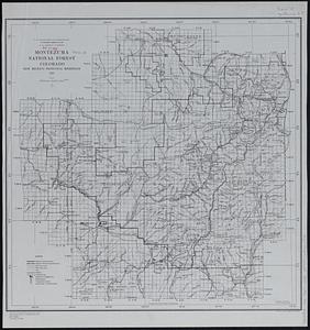
Montezuma National Forest, Colorado
7580.
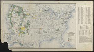
National forests, state forests, national parks, national monuments and Indian reservations
‹ Prev
Next ›
1
2
…
375
376
377
378
379
380
381
382
383
…
417
418