Toggle navigation
LMEC Home
Exhibitions
Georeferencing
Tools for Teachers
Collections
My Favorites
Sign Up / Log In
Search
Search the map portal
Map Collection
Map Collection
Map Sets
Search
Search
Search for
Search In
All Fields
Creator
Title
Subject
Place
Search All Digital Collections
Advanced Search
8651 Results
My Search
Start Over
More Like
commonwealth:3f462v08z
Remove constraint More Like: commonwealth:3f462v08z
Filter your Search
Place
North and Central America
5,887
United States
4,805
Massachusetts
2,068
Europe
1,392
Suffolk (county)
1,041
Boston
1,014
Canada
449
Asia
437
more
Place
»
Topic
Boston (Mass.)--Maps
582
United States--Maps
279
Real property--Massachusetts--Boston--Maps
175
Massachusetts--Maps
161
Landowners--Massachusetts--Boston--Maps
133
North America--Maps--Early works to 1800
103
New England--Maps
101
Europe--Maps
79
more
Topic
»
Date
Date range begin
–
Date range end
Current results range from
1482
to
2023
View distribution
Creator
United States. Hydrographic Office
595
O.H. Bailey & Co
148
Des Barres, Joseph F. W. (Joseph Frederick Wallet), 1722-1824
123
United States. Post Office Dept
120
Ptolemy, 2nd cent
100
Walling, Henry Francis, 1825-1888
94
Geological Survey (U.S.)
86
Jefferys, Thomas, -1771
85
more
Creator
»
Format
Maps/Atlases
8,591
Manuscripts
215
Prints
56
Books
36
Objects/Artifacts
10
Drawings/Illustrations
8
Posters
5
Georeferenced
Yes
870
No
7,781
Collection
Norman B. Leventhal Map & Education Center Collection
8,646
Boston and New England Maps
2,221
Urban Maps
1,992
Maritime Charts and Atlases
1,083
American Revolutionary War-Era Maps
619
Boston Redevelopment Authority Collection
87
American Antiquarian Society Collection
4
MacLean Collection Map Library
1
Available to use
No known restrictions
8,504
Creative Commons license
47
Search Constraints
Sort by relevance
relevance
title
date (asc)
date (desc)
Number of results to display per page
20 per page
10
per page
20
per page
50
per page
100
per page
View results as:
grid view
map view
Search Results
1.
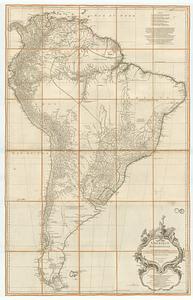
Carte générale de L'Amérique Méridionale et des îles qui en dépendent
2.
Colombie et Guyanes
3.
The good neighbor pictorial map of South America
4.
A map of South America according to the best authorities
5.
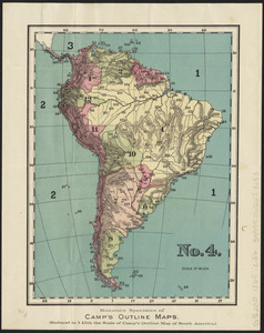
No. 4 : [South America]
6.
Peru, Chili and La Plata
7.
Rand, McNally & Co.'s indexed atlas of the world map of South America
8.
South America
9.
South America
10.
South America
11.
South America
12.
South America
13.
South America : reduced from the sheet map
14.
Südamerika
15.
Amérique Méridionale
16.
Map of the European settlements in South America and on the western coast of Africa
17.
Mapa de America sujecto à las observaciones astronomicas
18.
A New map of the whole continent of America, divided into North and South and West Indies. : With a descriptive account of the...
19.
A New map of the whole continent of America, divided into North and South and West Indies. : Wherein are exactly described the...
20.
The 100th anniversary map of Abraham Lincoln's visit to Massachusetts, September 11-23, 1848
‹ Prev
Next ›
1
2
3
4
5
…
432
433