Toggle navigation
LMEC Home
Exhibitions
Georeferencing
Tools for Teachers
Collections
My Favorites
Sign Up / Log In
Search
Search the map portal
Map Collection
Map Collection
Map Sets
Search
Search
Search for
Search In
All Fields
Creator
Title
Subject
Place
Search All Digital Collections
Advanced Search
8180 Results
My Search
Start Over
More Like
commonwealth:2514p130f
Remove constraint More Like: commonwealth:2514p130f
Filter your Search
Place
North and Central America
4,912
United States
3,602
Suffolk (county)
1,026
Boston
999
Europe
963
Canada
427
France
269
Massachusetts
249
more
Place
»
Topic
Boston (Mass.)--Maps
574
United States--Maps
270
Real property--Massachusetts--Boston--Maps
174
Massachusetts--Maps
160
Landowners--Massachusetts--Boston--Maps
132
North America--Maps--Early works to 1800
103
New England--Maps
99
Europe--Maps
78
more
Topic
»
Date
Date range begin
–
Date range end
Current results range from
1482
to
2023
View distribution
Creator
United States. Hydrographic Office
357
O.H. Bailey & Co
148
Des Barres, Joseph F. W. (Joseph Frederick Wallet), 1722-1824
123
United States. Post Office Dept
120
Ptolemy, 2nd cent
100
Walling, Henry Francis, 1825-1888
94
Jefferys, Thomas, -1771
85
Geological Survey (U.S.)
82
more
Creator
»
Format
Maps/Atlases
8,121
Manuscripts
215
Prints
51
Books
36
Objects/Artifacts
10
Drawings/Illustrations
8
Posters
4
Georeferenced
Yes
869
No
7,311
Collection
Norman B. Leventhal Map Center Collection
8,165
Boston and New England Maps
2,184
Urban Maps
1,925
Maritime Charts and Atlases
750
American Revolutionary War-Era Maps
622
Boston Redevelopment Authority Collection
86
Sidney R. Knafel Map Collection at Phillips Academy
9
New York Public Library Collection
4
more
Collection
»
Available to use
No known restrictions
8,021
Creative Commons license
55
Search Constraints
Sort by relevance
relevance
title
date (asc)
date (desc)
Number of results to display per page
20 per page
10
per page
20
per page
50
per page
100
per page
View results as:
grid view
map view
Search Results
21.
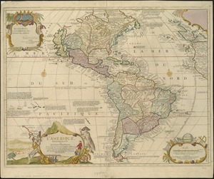
L'Amérique
22.
L'Amerique divisée par grand etats
23.
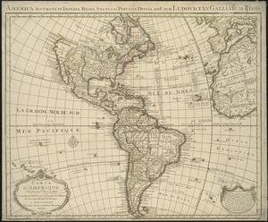
L'Amerique, meridionale, et septentrionale
24.
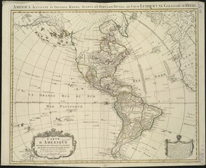
L'Amérique Septentrionale & Meridionale divisée en ses principales parties, ou sont distingués les vns des autres les estats...
25.
L'Amérique suivant le R.P. Charlevoix Jte, Mr. de La Condamine et plusieurs autres nouvle. observations
26.
Carte d'Amerique : dressée pour l'usage du Roy
27.
Carte d'Amerique : dressée pour l'usage du roy
28.
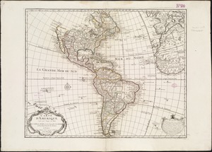
Carte d'Amerique divisées en ses principales parties
29.
Carte du Gouvernement de l'Amerique
30.
Chart of the track of the Dolphin, Tamar, Swallow & Endeavour through the South Seas ; & of the track of M. Bougainville round...
31.
The Earth's Western planisphere
32.
La Florida
33.
Mappa fluxus et refluxus rationes in isthmo Americano, in Freto Magellanico, cæterisque Americæ litoribus exhibens
34.
Maris Pacifici (quod vulgo Mar del Zur) cum regionibus circumiacentibus, insulisque in eodem passim sparsis, novissima descriptio
35.
A new general map of America
36.
A new map containing the English Empire Golf of Mexico Caribes Islands Granada Guiana Amazone and Peru
37.
A new map of America from the latest observations
38.
A new map of the whole continent of America, divided into North and South and West Indies : wherein are exactly described the...
39.
A new mapp of America devided according to the best and latest observations and discoveries wherein are described by thear...
40.
A new, plaine, and exact map of America : described by N.I. Visscher, and don into English, enlarged, and corrected, according...
‹ Prev
Next ›
1
2
3
4
5
6
…
408
409