Toggle navigation
LMEC Home
Exhibitions
Georeferencing
Tools for Teachers
Collections
My Favorites
Sign Up / Log In
Search
Search the map portal
Map Collection
Map Collection
Map Sets
Search
Search
Search for
Search In
All Fields
Creator
Title
Subject
Place
Search All Digital Collections
Advanced Search
8696 Results
My Search
Start Over
More Like
commonwealth:0z709563h
Remove constraint More Like: commonwealth:0z709563h
Filter your Search
Place
North and Central America
5,926
United States
4,844
Massachusetts
2,079
Europe
1,397
Suffolk (county)
1,046
Boston
1,019
Canada
449
Asia
438
more
Place
»
Topic
Boston (Mass.)--Maps
586
United States--Maps
282
Real property--Massachusetts--Boston--Maps
175
Massachusetts--Maps
162
Landowners--Massachusetts--Boston--Maps
133
North America--Maps--Early works to 1800
103
New England--Maps
102
Europe--Maps
79
more
Topic
»
Date
Date range begin
–
Date range end
Current results range from
1482
to
2023
View distribution
Creator
United States. Hydrographic Office
595
O.H. Bailey & Co
148
Des Barres, Joseph F. W. (Joseph Frederick Wallet), 1722-1824
123
United States. Post Office Dept
120
Ptolemy, 2nd cent
100
Walling, Henry Francis, 1825-1888
94
Geological Survey (U.S.)
86
Jefferys, Thomas, -1771
85
more
Creator
»
Format
Maps/Atlases
8,634
Manuscripts
215
Prints
56
Books
38
Objects/Artifacts
10
Drawings/Illustrations
8
Posters
5
Georeferenced
Yes
869
No
7,827
Collection
Norman B. Leventhal Map & Education Center Collection
8,694
Boston and New England Maps
2,233
Urban Maps
2,023
Maritime Charts and Atlases
1,083
American Revolutionary War-Era Maps
616
Boston Redevelopment Authority Collection
87
U.S. Government Documents Maps Collection
2
Available to use
No known restrictions
8,554
Creative Commons license
47
Search Constraints
Sort by relevance
relevance
title
date (asc)
date (desc)
Number of results to display per page
20 per page
10
per page
20
per page
50
per page
100
per page
View results as:
grid view
map view
Search Results
21.
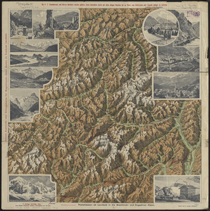
Plastische karte von Landeck, Tirol : ins ortlergebiet Kaunsertaler u. Oetztaleralpen, Silvretta u. Verwaligruppe...
22.
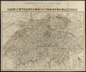
Reisekarte von der Schweiz nach den neuesten materialien berichtiget
23.
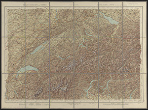
Relief-reisekarte der Schweiz = Carte-relief de la Suisse à l'usage des touristes
24.
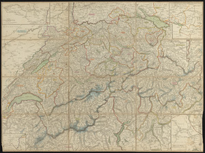
Schweiz
25.
Schweiz
26.
Die Schweiz
27.
Switzerland according to the best authorities
28.
Viaggio ai tre laghi Maggiore, di Lugano e di Como al Monte Rosa, al Sempione ed al Sacro Monte di Varallo
29.
Bacon's large scale seat of war - Metz to the Rhine
30.
Bacon's large scale war map : Paris to the Rhine
31.
Bacon's map of the seat of war from Paris to the Rhine
32.
Black's general map of the seat of war
33.
Black's special war map
34.
Carte de France indiquant les chemins de fer et les routes, avec les distances en kilomètres
35.
Carte des monuments historiques de la France, dressée d'après la liste établie par la Commission des monuments historiques
36.
Carte générale des routes de France : divisées en routes de poste, routes royales, départementales, stratégiques, chemins...
37.
Carte geographique et commerciale de la France et de son domaine colonial : indiquant les départements, routes principales,...
38.
Carte orographique hydrographique et routière de la France : comprenant le bassin du rhin et la région des Alpes occidentales...
39.
Carte routière de la France, dressée spécialement pour tous les guides du voyageur
40.
Comparative map of distances between Paris & Cologne, and likewise between Dover and Cologne
‹ Prev
Next ›
1
2
3
4
5
6
…
434
435