Toggle navigation
LMEC Home
Exhibitions
Georeferencing
Tools for Teachers
Collections
My Favorites
Sign Up / Log In
Search
Search the map portal
Map Collection
Map Collection
Map Sets
Search
Search
Search for
Search In
All Fields
Creator
Title
Subject
Place
Search All Digital Collections
Advanced Search
8705 Results
My Search
Start Over
More Like
commonwealth:0z7092645
Remove constraint More Like: commonwealth:0z7092645
Filter your Search
Place
North and Central America
5,936
United States
4,847
Massachusetts
2,079
Europe
1,396
Suffolk (county)
1,046
Boston
1,019
Canada
459
Asia
438
more
Place
»
Topic
Boston (Mass.)--Maps
586
United States--Maps
282
Real property--Massachusetts--Boston--Maps
175
Massachusetts--Maps
163
Landowners--Massachusetts--Boston--Maps
133
New England--Maps
104
North America--Maps--Early works to 1800
103
Europe--Maps
79
more
Topic
»
Date
Date range begin
–
Date range end
Current results range from
1482
to
2023
View distribution
Creator
United States. Hydrographic Office
595
O.H. Bailey & Co
148
Des Barres, Joseph F. W. (Joseph Frederick Wallet), 1722-1824
123
United States. Post Office Dept
120
Ptolemy, 2nd cent
100
Walling, Henry Francis, 1825-1888
94
Geological Survey (U.S.)
86
Jefferys, Thomas, -1771
85
more
Creator
»
Format
Maps/Atlases
8,645
Manuscripts
215
Prints
56
Books
36
Objects/Artifacts
10
Drawings/Illustrations
8
Posters
5
Georeferenced
Yes
869
No
7,836
Collection
Norman B. Leventhal Map & Education Center Collection
8,695
Boston and New England Maps
2,234
Urban Maps
2,023
Maritime Charts and Atlases
1,083
American Revolutionary War-Era Maps
626
Boston Redevelopment Authority Collection
87
William L. Clements Library Collection
7
American Antiquarian Society Collection
1
more
Collection
»
Available to use
No known restrictions
8,553
Creative Commons license
48
Search Constraints
Sort by relevance
relevance
title
date (asc)
date (desc)
Number of results to display per page
20 per page
10
per page
20
per page
50
per page
100
per page
View results as:
grid view
map view
Search Results
1.
A new chart of ye coast of New Found Land, New Scotland and New England &c.
2.
North America : British provinces of New Brunswick, Nova Scotia, & part of Canada : compiled from recent surveys and adjusted...
3.
An exact map of Nova Scotia, Newfoundland, gulf and river St. Laurence, and coast of Labrador from the latest observations 1777
4.
A new and accurate map of the province of Nova Scotia, in North America; from the latest observations
5.
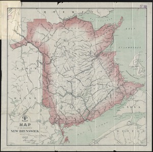
Map of the province of New Brunswick
6.
Map of the state of Maine with the province of New Brunswick
7.
A map of Upper and Lower Canada : with part of the United States adjoining, comprising the present seat of war
8.
McMillan's map of New Brunswick, 1867
9.
Canada and Nova Scotia
10.
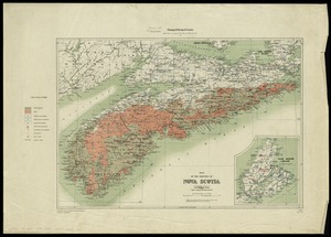
Map of the province of Nova Scotia including Cape Breton Prince Edwards Island and part of New Brunswick
11.
Map of the province of Nova Scotia to illustrate report by E.R. Faribault, B.A. Sc. on the "Gold fields of Nova Scotia"
12.
The River & Gulf of St. Lawrence, Newfoundland, Nova Scotia, and the banks adjacent : from the British Admiralty, French Marine...
13.
S.e. coast of Nova Scotia : from the most recent British surveys
14.
A small map of the sea coast of New England together with the outlines of several of the provinces lying thereon, 1738
15.
The coast from St. Johns, New Brunswick, to Goldsborough Bay, Maine
16.
Explorer's map & directory of the New England Coast : New London, Connecticut, to Passamaquoddy Bay, Canada : a comprehensive...
17.
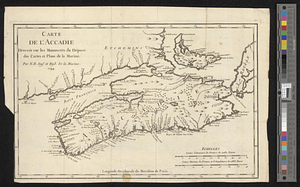
Carte de l'Accadie : dressée sur les manuscrits de Dépot des Cartes et Plans de la Marine
18.
A chart of the peninsula of Nova Scotia
19.
L'Isle de Terre-Neuve, l'Acadie, ou la Nouvelle Ecosse, : l'Isle St. Jean et la partie orientale du Canada
20.
Map of the coast of Cape Breton from Fort William to Louisbourg
‹ Prev
Next ›
1
2
3
4
5
…
435
436