Toggle navigation
LMEC Home
Exhibitions
Georeferencing
Tools for Teachers
Collections
My Favorites
Sign Up / Log In
Search
Search the map portal
Map Collection
Map Collection
Map Sets
Search
Search
Search for
Search In
All Fields
Creator
Title
Subject
Place
Search All Digital Collections
Advanced Search
526 Results
My Search
Start Over
More Like
commonwealth:q524nd88q
Remove constraint More Like: commonwealth:q524nd88q
Place
North and Central America
Remove constraint Place: North and Central America
Filter your Search
Place
North and Central America
[remove]
526
United States
386
Suffolk (county)
66
Boston
65
Massachusetts
54
New York
42
Boston Harbor
26
Canada
25
more
Place
»
Topic
Manuscript maps--Early works to 1800
117
Boston (Mass.)--Maps--Early works to 1800
49
Manuscript maps
21
Bunker Hill, Battle of, Boston, Mass., 1775--Maps--Early works to 1800
20
Boston Harbor (Mass.)--Maps--Early works to 1800
19
Boston (Mass.)--History--Revolution, 1775-1783--Maps--Early works to 1800
18
Fortification--New York (State)--New York--Maps--Early works to 1800
11
Gulf Coast (U.S.)--Maps, Manuscript--Early works to 1800
11
more
Topic
»
Date
Date range begin
–
Date range end
Current results range from
1694
to
1899
1694 : 1900
1694
1900
View distribution
Creator
Hills, John, (Surveyor)
18
Montrésor, John, 1736-1799
18
Dumont de Montigny
12
Bingham, William, 1752-1804
11
Faden, William, 1749-1836
10
Adlum, John, 1759-1836
9
Washington, George, 1732-1799
9
Page, Thomas Hyde, Sir, 1746-1821
8
more
Creator
»
Format
Maps/Atlases
524
Manuscripts
460
Objects/Artifacts
2
Georeferenced
Yes
12
No
514
Collection
American Revolutionary War-Era Maps
512
Library of Congress Collection
427
Boston and New England Maps
53
Norman B. Leventhal Map & Education Center Collection
52
Urban Maps
40
Newberry Library Collection
36
Maritime Charts and Atlases
33
Mapping Boston Collection
13
more
Collection
»
Available to use
Creative Commons license
446
No known restrictions
42
Search Constraints
Sort by relevance
relevance
title
date (asc)
date (desc)
Number of results to display per page
20 per page
10
per page
20
per page
50
per page
100
per page
View results as:
grid view
map view
Search Results
1.
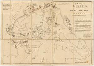
A plan of Boston, and its environs : shewing the true situation of His Majesty's army, and also those of the rebels
2.
The seat of war, in New England, by an American volunteer : with the marches of the several corps sent by the colonies, towards...
3.
The seat of war in New England, by an American volunteer : with the marches of the several corps sent by the Colonies towards...
4.
The seat of war in New England, by an American volunteer : with the marches of the several corps sent by the Colonies towards...
5.
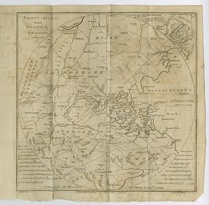
Thirty-miles round Boston
6.
20 tracts, Charleston
7.
Armstrong County
8.
Boston & harbour
9.
Boston Harbor, Massachusetts
10.
Carta esférica de la canal entre Puerto Rico y Santo Domingo
11.
Carte de l'entrée du port et rade de Pensacola
12.
Cawanesque
13.
Chart of the sea coast from latitude 27⁰00ʹ00ʺ to 27⁰20ʹ00ʺ, with Little Inlet & River into Hillsborough River ; Chart of the...
14.
Chart of the sea coast from lattde. 26⁰20ʹ00ʺ to 26⁰ & 40ʹ00ʺ with the head of Sharkshead River ; Chart of New Inlet ; Chart of...
15.
Costa desde la Mobila asta la Bahía de Sn. Josef
16.
Dotted line map of Washington, D.C., 1791, before Aug. 19th
17.
Draft of roads in New Jersey
18.
A draught of Lake George, and part of Hudson's River taken September 1756
19.
Fort Edward to Crown Point
20.
Jefferson, Venango & Armstrong
‹ Prev
Next ›
1
2
3
4
5
…
26
27


![Chart of the sea coast from latitude 27⁰00ʹ00ʺ to 27⁰20ʹ00ʺ, with Little Inlet & River into Hillsborough River ; Chart of the sea coast from latitude 26⁰40ʹ00ʺ to [27⁰]00ʹ00ʺ, the Leech Shoal & Hillsborough River](https://bpldcassets.blob.core.windows.net/derivatives/images/commonwealth:q524nd97p/image_thumbnail_300.jpg)


