Toggle navigation
LMEC Home
Exhibitions
Georeferencing
Tools for Teachers
Collections
My Favorites
Sign Up / Log In
Search
Search the map portal
Map Collection
Map Collection
Map Sets
Search
Search
Search for
Search In
All Fields
Creator
Title
Subject
Place
Search All Digital Collections
Advanced Search
199 Results
My Search
Start Over
More Like
commonwealth-oai:x633k0531
Remove constraint More Like: commonwealth-oai:x633k0531
Place
New York
Remove constraint Place: New York
Filter your Search
Place
New York
[remove]
199
North and Central America
199
United States
199
Westchester (county)
26
Hudson River
16
Manhattan
16
Long Island
15
New Jersey
15
more
Place
»
Topic
United States--History--Revolution, 1775-1783--Maps
82
United States--History--French and Indian War, 1754-1763--Maps
46
New York (State)--Maps
31
Westchester County (N.Y.)--Maps
18
Hudson River (N.Y. and N.J.)--Maps
16
Manhattan (New York, N.Y.)--Maps
16
Long Island (N.Y.)--Maps
15
Staten Island (New York, N.Y.)--Maps
15
more
Topic
»
Date
Date range begin
–
Date range end
Current results range from
1700
to
1908
1700 : 1909
1700
1909
View distribution
Creator
Rocque, Mary Ann
20
Holland, Samuel, 1728-1801
7
André, John, 1751-1780
6
Clinton, Henry, Sir, 1738?-1795
6
Martin, Reinhard Jacob
6
Ratzer, Bernard
5
Montrésor, John, 1736-1799
4
Thompson, Alexander (Surveyor)
4
more
Creator
»
Format
Maps/Atlases
198
Drawings/Illustrations
1
Manuscripts
1
Prints
1
Georeferenced
Yes
1
No
198
Collection
American Revolutionary War-Era Maps
196
William L. Clements Library Collection
192
Maps from AAS
3
Norman B. Leventhal Map & Education Center Collection
3
MacLean Collection Map Library
1
Available to use
No known restrictions
3
Search Constraints
Sort by relevance
relevance
title
date (asc)
date (desc)
Number of results to display per page
20 per page
10
per page
20
per page
50
per page
100
per page
View results as:
grid view
map view
Search Results
1.
Reconnoissance des ouvrages de Ouët Point : etablis pour couvrir et assurer la communication des états du nord avec ceux du...
2.
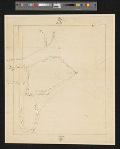
Bridge from Staten Island to the Jersies, by Cn. Laird's description
3.
Part of the modern counties of Union, Somerset, Hunterdon, Morris, Essex, Bergen, Passaic, Sussex, and Warren in New Jersey and...
4.
Southern New York and northern New Jersey
5.
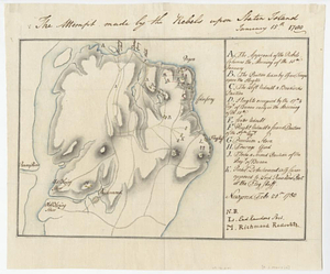
The attempt made by the rebels upon Staten Island January 15th 1780
6.
Bedford &c.
7.
Blackwell's Island
8.
British troop dispositions in and near New York City
9.
British troop dispositions in and near New York City, July and August 1781
10.
British troop dispositions in and near New York City, Sept. 2d 1781
11.
Disposition of the British forces on Long Island, Staten Island, and Manhattan Island, under Cornwallis and Knyphausen
12.
Distances North River
13.
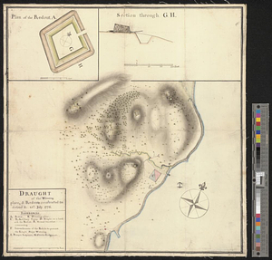
Draught of the watering place & redouts constructed to defend it, 15th: July 1776
14.
Flatbush
15.
Fort Independence to Slaughter's Landing
16.
Fort Lafayette and Verplank Point
17.
Forts of the Highlands, ca. 1777
18.
Fragment of map showing two small fortifications
19.
From Fishkill Creek to the Croton River
20.
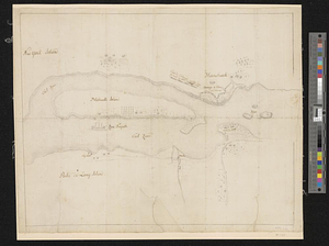
Haverstraw Bay and vicinity
‹ Prev
Next ›
1
2
3
4
5
…
9
10