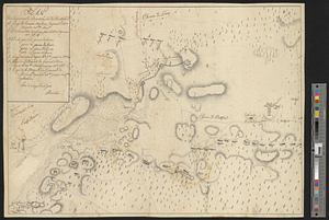
Flatbush

This map is also available in American Revolutionary Geographies Online (ARGO), a collections portal especially built for material relating to the American Revolutionary War Era. Visit ARGO to learn more about this item and explore the historical geography of North America in the late eighteenth century.
Item Information
- Title:
- Flatbush
- Contributor:
- Clinton, Henry, Sir, 1738?-1795
- Contributor:
- Bache, Theophylact, 1735-1807
- Date:
-
[1770–1779]
- Format:
-
Maps/Atlases
- Genre:
-
Manuscript maps
- Location:
- William L. Clements Library
- Collection (local):
-
William L. Clements Library Collection
- Subjects:
-
Flatbush (Ulster County, N.Y.)--Maps
Brooklyn (New York, N.Y.)--Maps
United States--History--Revolution, 1775-1783--Maps
- Places:
-
New YorkUlster (county)Flatbush
New YorkNew YorkBrooklyn (borough)
- Extent:
- 1 ms. map ; 40.5 x 33 cm
- Terms of Use:
-
The University of Michigan Library provides access to these materials for educational and research purposes. These materials may be under copyright. If you decide to use any of these materials, you are responsible for making your own legal assessment and securing any necessary permission. If you have questions about the collection, please contact the William L. Clements Library.
Contact host institution for more information.
- Scale:
-
Scale [ca. 1:5,160].
- Language:
-
English
- Catalog Record:
-
Catalog record
- Notes:
-
Pen and ink topographical map showing Flatbush and roads to adjoining towns.
Manuscript note in the hand of Sir Henry Clinton: Sketch from Mr. Theoph. Baches ideas of the country.
Clinton Maps 135.
- Notes (date):
-
This date is inferred.
- Identifier:
-
1809
- Barcode:
-
B1936382


![Part of the city of New York, 27th Augt: 1778 [and] part of Long Island](https://bpldcassets.blob.core.windows.net/derivatives/metadata/commonwealth-oai:6d573t30q/image_thumbnail_300.jpg)