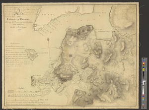
A map of the environs of Brooklyn : surveyed by order of his excellency General Sir Henry Clinton K.B., commander in chief of his majesty's forces &c. &c.

This map is also available in American Revolutionary Geographies Online (ARGO), a collections portal especially built for material relating to the American Revolutionary War Era. Visit ARGO to learn more about this item and explore the historical geography of North America in the late eighteenth century.
Item Information
- Title:
- A map of the environs of Brooklyn : surveyed by order of his excellency General Sir Henry Clinton K.B., commander in chief of his majesty's forces &c. &c.
- Creator:
- Skinner, Andrew (Geographer)
- Name on Item:
-
by Andw. Skinner 1781
- Date:
-
1781
- Format:
-
Maps/Atlases
- Genre:
-
Manuscript maps
- Location:
- William L. Clements Library
- Collection (local):
-
William L. Clements Library Collection
- Subjects:
-
Brooklyn (New York, N.Y.)--Maps
United States--History--Revolution, 1775-1783--Maps
- Places:
-
New YorkNew YorkBrooklyn (borough)
- Extent:
- 1 ms. map : outline col. ; 73.5 x 53 cm.
- Terms of Use:
-
The University of Michigan Library provides access to these materials for educational and research purposes. These materials may be under copyright. If you decide to use any of these materials, you are responsible for making your own legal assessment and securing any necessary permission. If you have questions about the collection, please contact the William L. Clements Library.
Contact host institution for more information.
- Scale:
-
Scale 1 inch to 10 chains.
- Language:
-
English
- Catalog Record:
-
Catalog record
- Notes:
-
Finished, colored, topographical map of the area from Wallabout Bay on the north to Red Hook on the south and from the Battery on the Manhattan side of the East River to about one mile east of Brooklyn.
It shows roads, taverns, churches, and farmhouses of the principal landowners.
Major fortifications are identified.
Clinton Map 131.
- Identifier:
-
8656
- Barcode:
-
B2826557

![Part of the city of New York, 27th Augt: 1778 [and] part of Long Island](https://bpldcassets.blob.core.windows.net/derivatives/metadata/commonwealth-oai:6d573t30q/image_thumbnail_300.jpg)