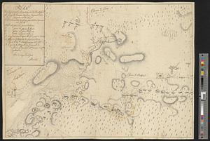
Part of the city of New York, 27th Augt: 1778 [and] part of Long Island
![Part of the city of New York, 27th Augt: 1778 [and] part of Long Island](https://bpldcassets.blob.core.windows.net/derivatives/metadata/commonwealth-oai:6d573t30q/image_thumbnail_300.jpg)
This map is also available in American Revolutionary Geographies Online (ARGO), a collections portal especially built for material relating to the American Revolutionary War Era. Visit ARGO to learn more about this item and explore the historical geography of North America in the late eighteenth century.
Item Information
- Title:
- Part of the city of New York, 27th Augt: 1778 [and] part of Long Island
- Creator:
- Wheeler, Thomas (Surveyor)
- Date:
-
August 27, 1778
- Format:
-
Maps/Atlases
- Genre:
-
Manuscript maps
- Location:
- William L. Clements Library
- Collection (local):
-
William L. Clements Library Collection
- Subjects:
-
Brooklyn (New York, N.Y.)--Maps
United States--History--Revolution, 1775-1783--Maps
- Places:
-
New YorkNew YorkBrooklyn (borough)
- Extent:
- 1 ms. map : col. ; 57.5 x 72.7 cm.
- Terms of Use:
-
The University of Michigan Library provides access to these materials for educational and research purposes. These materials may be under copyright. If you decide to use any of these materials, you are responsible for making your own legal assessment and securing any necessary permission. If you have questions about the collection, please contact the William L. Clements Library.
Contact host institution for more information.
- Scale:
-
Scale 1:4,800.
- Language:
-
English
- Catalog Record:
-
Catalog record
- Notes:
-
Inside neat line at lower right: Drawn by Thos. Wheeler.
Finished, colored, topographical map of the area on the Long Island side of the East River from Wallabout Bay to Governor's Island and on the Manhattan side from the Battery to Crown Point.
Includes details of built-up areas, fortifications and farms.
The encampment of the 64th Regiment of Foot is shown at the eastern edge of Brooklyn.
Clinton Map 140.
- Identifier:
-
8376
- Barcode:
-
B2819640