Toggle navigation
LMEC Home
Exhibitions
Georeferencing
Tools for Teachers
Collections
My Favorites
Sign Up / Log In
Search
Search the map portal
Map Collection
Map Collection
Map Sets
Search
Search
Search for
Search In
All Fields
Creator
Title
Subject
Place
Search All Digital Collections
Advanced Search
1395 Results
My Search
Start Over
More Like
commonwealth:2514p0642
Remove constraint More Like: commonwealth:2514p0642
Place
Europe
Remove constraint Place: Europe
Filter your Search
Place
Europe
[remove]
1,395
France
305
Germany
176
Italy
169
England
152
Île-de-France
53
Balkan Peninsula
49
Spain
47
more
Place
»
Topic
Europe--Maps
78
France--Maps
56
Germany--Maps
56
Paris (France)--Maps
39
Balkan Peninsula--Maps
37
Franco-Prussian War, 1870-1871--Maps
33
Europe, Central--Maps
32
London (England)--Maps
28
more
Topic
»
Date
Date range begin
–
Date range end
Current results range from
1482
to
1996
1482 : 1997
1482
1997
View distribution
Creator
Jansson, Jan, 1588-1664
55
Wit, Frederik de.
53
Ptolemy, 2nd cent
47
Pufendorf, Samuel, Freiherr von, 1632-1694
46
Riegel, Christoph
46
Dahlbergh, Erik Jönsson, greve, 1625-1703
44
United States. Hydrographic Office
42
Sanson, Nicolas, 1600-1667
28
more
Creator
»
Format
Maps/Atlases
1,376
Prints
19
Manuscripts
3
Georeferenced
Yes
80
No
1,315
Collection
Norman B. Leventhal Map & Education Center Collection
1,395
Urban Maps
159
Maritime Charts and Atlases
60
Boston and New England Maps
1
Available to use
No known restrictions
1,393
Creative Commons license
1
Search Constraints
Sort by relevance
relevance
title
date (asc)
date (desc)
Number of results to display per page
20 per page
10
per page
20
per page
50
per page
100
per page
View results as:
grid view
map view
Search Results
1.
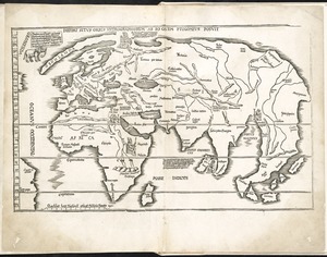
Ævi veteris usque ad annum salutis nonagesimum supra milles quadringentos cogniti tantum, typus geographica
2.
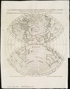
A new projection of the Eastern Hemisphere of the earth on a plane : shewing the proportions of its several parts nearly as on...
3.
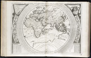
Orbis typus universalis iuxta hydrographorum traditionem exactissime depicta 1522 L.F
4.
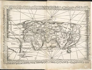
Planisfero del mondo vecchio
5.
Tabula moder. Gronlandiae et Russiae
6.
227 Harzgerode
7.
305 Glatz
8.
4 Kinten
9.
The A.A.A. key road map of continental Europe
10.
Accurata delineatio Castrorum Suecicorum, ut et Haffniae, Regni Daniae Metropolis
11.
Accurata delineatio oppugnatae a faederatis, Caesareis, Polonicis, Danicis, et Brandeburgicis copijs sub-ductu Seren: Electoris...
12.
Accurata delineatio regionis circa Nieburgum Fioniæ cum prælio ibi commisso inter Danorum et fæderatorum exercitum ab una et...
13.
Accurata Scaniae, Blekingiae et Hallandiae descriptio
14.
An accurate map of Dorset Shire divided into hundreds
15.
An accurate map of Dorset Shire, divided into its hundreds
16.
An accurate map of England and Wales with the principal roads from the best authorities
17.
An accurate map of England and Wales with the principal roads from the best authorities
18.
An accurate map of Europe from the best authorities
19.
An accurate map of the county of Essex, divided into its hundreds
20.
Accuratissima Circuli Saxoniae tabula quae est pars septentrionalis Germaniae
‹ Prev
Next ›
1
2
3
4
5
…
69
70