Toggle navigation
LMEC Home
Exhibitions
Georeferencing
Tools for Teachers
Collections
My Favorites
Sign Up / Log In
Search
Search the map portal
Map Collection
Map Collection
Map Sets
Search
Search
Search for
Search In
All Fields
Creator
Title
Subject
Place
Search All Digital Collections
Advanced Search
477 Results
My Search
Start Over
More Like
commonwealth:0z709278h
Remove constraint More Like: commonwealth:0z709278h
Place
Canada
Remove constraint Place: Canada
Filter your Search
Place
Canada
[remove]
477
North and Central America
477
Nova Scotia
102
United States
89
Newfoundland and Labrador
68
Quebec
60
Province of British Columbia
41
Province of New Brunswick
35
more
Place
»
Topic
Nova Scotia--Maps--Early works to 1800
35
Canada--Maps
32
Coasts--Nova Scotia--Maps--Early works to 1800
28
British Columbia--Maps
25
Nautical charts--Nova Scotia--Early works to 1800
24
Canada--Maps--Early works to 1800
23
Coasts--Newfoundland and Labrador--Maps
20
Québec (Province)--Maps
18
more
Topic
»
Date
Date range begin
–
Date range end
Current results range from
1548
to
1999
1548 : 2000
1548
2000
1550
1600
1650
1700
1750
1800
1850
1900
1950
2000
Creator
United States. Hydrographic Office
84
Des Barres, Joseph F. W. (Joseph Frederick Wallet), 1722-1824
52
Klakring, A. (Alfred)
20
Geological Survey of Canada
15
Canada. Department of the Interior
14
Wimpffen, L. F. von (Lebreclit Felix von)
11
Jefferys, Thomas, -1771
10
Ourdan, V. L. (Vincent L.)
10
more
Creator
»
Format
Maps/Atlases
477
Manuscripts
3
Georeferenced
Yes
11
No
466
Collection
Norman B. Leventhal Map & Education Center Collection
449
Maritime Charts and Atlases
156
American Revolutionary War-Era Maps
136
Urban Maps
28
William L. Clements Library Collection
20
Boston and New England Maps
15
Library and Archives Canada Collection
4
MacLean Collection Map Library
2
more
Collection
»
Available to use
No known restrictions
449
Creative Commons license
1
Search Constraints
Sort by relevance
relevance
title
date (asc)
date (desc)
Number of results to display per page
20 per page
10
per page
20
per page
50
per page
100
per page
View results as:
grid view
map view
Search Results
1.
An exact map of Nova Scotia, Newfoundland, gulf and river St. Laurence, and coast of Labrador from the latest observations 1777
2.
Map of the Eastern Railroad and principal connections
3.
Coal fields of Nova Scotia and New Brunswick
4.
A new chart of ye coast of New Found Land, New Scotland and New England &c.
5.
Map of the state of Maine with the province of New Brunswick
6.
A new and accurate map of the province of Nova Scotia, in North America; from the latest observations
7.
The coast from St. Johns, New Brunswick, to Goldsborough Bay, Maine
8.
Explorer's map & directory of the New England Coast : New London, Connecticut, to Passamaquoddy Bay, Canada : a comprehensive...
9.
A plan of a rout from Fort Pownall on the river Penobscot in New England to Quebec and from Quebec to Fort Pownall : taken by...
10.
Sketch of different passes into Canada from our lower provinces
11.
Topographical map of the province of New Hampshire, including Montresor's survey of the St. Lawrence and the Kennebec route to...
12.
Map of the Eastern Railroad and principal connections
13.
Map showing the number of chartered banks in New Brunswick, Nova Scotia, and Prince Edward Island
14.
North America, Dominion of Canada, Gulf of St. Lawrence, Prince Edward Island and adjacent coasts, from Sea Wolf Island to...
15.
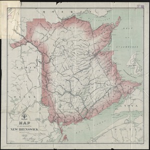
Map of the province of New Brunswick
16.
McMillan's map of New Brunswick, 1867
17.
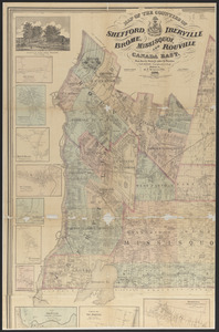
Map of the counties of Shefford, Iberville, Brome, Missisquoi, and Rouville, Canada East
18.
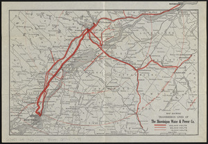
Map showing transmission lines of the Shawinigan Water & Power Co.
19.
Canada and Nova Scotia
20.
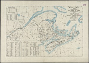
Map of the province of Nova Scotia including Cape Breton Prince Edwards Island and part of New Brunswick
‹ Prev
Next ›
1
2
3
4
5
…
23
24