Toggle navigation
LMEC Home
Exhibitions
Georeferencing
Tools for Teachers
Collections
My Favorites
Sign Up / Log In
Search
Search the map portal
Map Collection
Map Collection
Map Sets
Search
Search
Search for
Search In
All Fields
Creator
Title
Subject
Place
Search All Digital Collections
Advanced Search
21 Results
My Search
Start Over
More Like
commonwealth-oai:s1788k90r
Remove constraint More Like: commonwealth-oai:s1788k90r
Topic
Hudson River (N.Y. and N.J.)--Maps
Remove constraint Topic: Hudson River (N.Y. and N.J.)--Maps
Filter your Search
Place
Hudson River
21
North and Central America
21
United States
21
New York
15
Orange (county)
7
West Point
7
Westchester (county)
5
Fort Montgomery (historical)
4
more
Place
»
Topic
Hudson River (N.Y. and N.J.)--Maps
[remove]
21
United States--History--Revolution, 1775-1783--Maps
15
West Point (N.Y.)--Maps
7
Hudson Highlands (N.Y.)--Maps
6
Fort Montgomery (N.Y.)--Maps
4
Castle Clinton (New York, N.Y.)--Maps
3
Putnam County (N.Y.)--Maps
3
Dashwood, Francis, Sir, 1708-1781
2
more
Topic
»
Date
Date range begin
–
Date range end
Current results range from
1754
to
1780
1754 : 1781
1754
1781
View distribution
Creator
Ferguson, Patrick, 1744-1780
3
Holland, Samuel, 1728-1801
2
Clinton, Henry, Sir, 1738?-1795
1
Hammill, Daniel
1
Martin, Reinhard Jacob
1
Robert Sayer and John Bennett (Firm)
1
Robinson, Beverly, 1722-1792
1
Format
Maps/Atlases
21
Drawings/Illustrations
1
Georeferenced
No
21
Collection
American Revolutionary War-Era Maps
21
William L. Clements Library Collection
21
Search Constraints
Sort by relevance
relevance
title
date (asc)
date (desc)
Number of results to display per page
20 per page
10
per page
20
per page
50
per page
100
per page
View results as:
grid view
map view
Search Results
1.
Distances North River
2.
Hudson River from Anthony's Nose to Stony Point
3.
Hudson River from Peekskill to Slaughters Landing
4.
Hudson River from Stony Point to West Point
5.
Hudson River from West Point to Dobbs Ferry
6.
Hudson's River from Stony Pt. to Fort Montgomery
7.
Lent's Creek and Baillies Creek
8.
Moore's sketch of the navigation of the Highlands
9.
Part of the modern counties of Dutchess, Putnam, and Westchester
10.
Plan des environs de West Point jusqu'au Croton River... : Morrishous ce 14me Juin 1779
11.
The seat of action between the British and American forces or an authentic plan of Staten Island with the neighbouring...
12.
The seat of action, between the British and American forces or an authentic plan of the western part of Long Island, with the...
13.
Valley of the Hudson River from Fishkill to Teller's Point
14.
Verplanks
15.
West Point; or Fort Defiance
16.
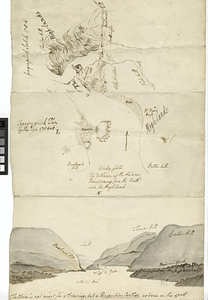
Geographick scetch [sic], 1754
17.
Hudson River highlands at Martelaers Rock
18.
Hudson's River from New York to Albany
19.
Map from Albany to Crown Point
20.
Map of North River from Stoney Point to Peeks Kill
+
-
Redo search here
Search when I move the map
Leaflet
| ©
OpenStreetMap
contributors, ©
CartoDB
‹ Prev
Next ›
1
2


![Geographick scetch [sic], 1754](https://bpldcassets.blob.core.windows.net/derivatives/metadata/commonwealth-oai:pk02h894n/image_thumbnail_300.jpg)