Toggle navigation
LMEC Home
Exhibitions
Georeferencing
Tools for Teachers
Collections
My Favorites
Sign Up / Log In
Search
Search the map portal
Map Collection
Map Collection
Map Sets
Search
Search
Search for
Search In
All Fields
Creator
Title
Subject
Place
Search All Digital Collections
Advanced Search
11 Results
My Search
Start Over
More Like
commonwealth:q524nc98r
Remove constraint More Like: commonwealth:q524nc98r
Topic
Fortification--New York (State)--New York--Maps--Early works to 1800
Remove constraint Topic: Fortification--New York (State)--New York--Maps--Early works to 1800
Filter your Search
Place
North and Central America
11
United States
11
New York
10
Bronx
3
Manhattan
2
Hell Gate
1
New York (county)
1
The Narrows
1
Topic
Fortification--New York (State)--New York--Maps--Early works to 1800
[remove]
11
New York (N.Y.)--Buildings, structures, etc--Maps, Manuscript--Early works to 1800
9
Kingsbridge (New York, N.Y.)--Buildings, structures, etc--Maps, Manuscript--Early works to 1800
3
New York (N.Y.)--Maps, Manuscript--Early works to 1800
3
Hell Gate (New York, N.Y.)--Maps, Manuscript--Early works to 1800
1
Manhattan (New York, N.Y.)--Buildings, structures, etc--Maps, Manuscript--Early works to 1800
1
Manhattan (New York, N.Y.)--Maps, Manuscript--Early works to 1800
1
Narrows (N.Y.)--Maps, Manuscript--Early works to 1800
1
more
Topic
»
Date
Date range begin
–
Date range end
Current results range from
1776
to
1781
1776 : 1782
1776
1782
View distribution
Creator
Montrésor, John, 1736-1799
2
Blaskowitz, Charles
1
Format
Manuscripts
11
Maps/Atlases
11
Georeferenced
No
11
Collection
American Revolutionary War-Era Maps
11
Library of Congress Collection
11
Available to use
Creative Commons license
11
Search Constraints
Sort by relevance
relevance
title
date (asc)
date (desc)
Number of results to display per page
20 per page
10
per page
20
per page
50
per page
100
per page
View results as:
grid view
map view
Search Results
1.
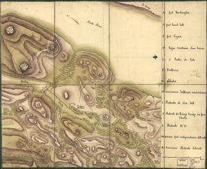
Disposition of British troops, with fortifications north of Fort Knipehausen, i.e. Fort Washington to Fort Independence
2.
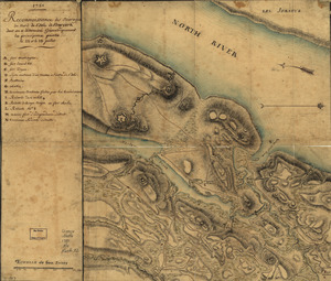
Map of defenses of New York Island from Fort Washington to Fort Independence, with redoubts, etc. planned between
3.
New York Island : Military; unfinished
4.
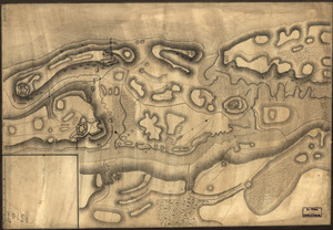
Nord de l'Ile de New-York
5.
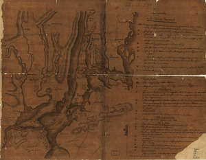
Plan de New-York et les environs
6.
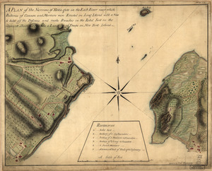
A plan of the Narrows of Hells-gate in the East River : near which batteries of cannon and mortars were erected on Long Island...
7.
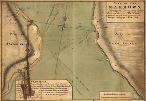
Plan of The Narrows, shewing the channel, shoal, depth of water, and the several battery's proposed on each side to prevent an...
8.
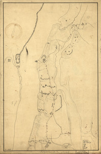
Reconnoissance de King's bridge : I
9.
Reconnoissance des ouvrages du nord de l'Isle de Newyork dont on a déterminé géometriquement les principaux points le 22 et...
10.
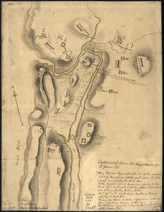
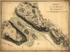
Sketch of the Heights of Kingsbridge 1777, with the proposed redoubts coloured orange : Old rebel works coloured black
11.
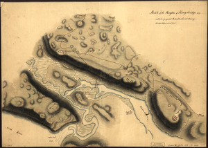
Sketch of the Heights of Kingsbridge, with the proposed redouts couloured yellow