Toggle navigation
LMEC Home
Exhibitions
Georeferencing
Tools for Teachers
Collections
My Favorites
Sign Up / Log In
Search
Search the map portal
Map Collection
Map Collection
Map Sets
Search
Search
Search for
Search In
All Fields
Creator
Title
Subject
Place
Search All Digital Collections
Advanced Search
909 Results
My Search
Start Over
More Like
commonwealth-oai:2r36zw60c
Remove constraint More Like: commonwealth-oai:2r36zw60c
Collection
William L. Clements Library Collection
Remove constraint Collection: William L. Clements Library Collection
Filter your Search
Place
North and Central America
883
United States
623
Canada
205
New York
191
Quebec
111
Pennsylvania
60
New Jersey
54
Nova Scotia
48
more
Place
»
Topic
United States--History--Revolution, 1775-1783--Maps
305
United States--History--French and Indian War, 1754-1763--Maps
149
Saint Lawrence River--Maps
43
Newport (R.I.)--Maps
27
New York (State)--Maps
24
Hudson River (N.Y. and N.J.)--Maps
21
Québec (Québec)--Maps
21
Louisbourg (N.S.)--Maps
20
more
Topic
»
Date
Date range begin
–
Date range end
Current results range from
1700
to
1899
1700 : 1900
1700
1900
View distribution
Creator
Rocque, Mary Ann
29
Holland, Samuel, 1728-1801
25
Montrésor, John, 1736-1799
25
Bellin, Jacques Nicolas, 1703-1772
24
Jefferys, Thomas, -1771
24
Clinton, Henry, Sir, 1738?-1795
19
Robert Sayer and John Bennett (Firm)
15
Hills, John, active 1777-1819
13
more
Creator
»
Format
Maps/Atlases
893
Drawings/Illustrations
11
Documents
5
Prints
1
Georeferenced
No
909
Collection
American Revolutionary War-Era Maps
909
William L. Clements Library Collection
[remove]
909
Search Constraints
Sort by relevance
relevance
title
date (asc)
date (desc)
Number of results to display per page
20 per page
10
per page
20
per page
50
per page
100
per page
View results as:
grid view
map view
Search Results
1.
Gardiners Bay
2.
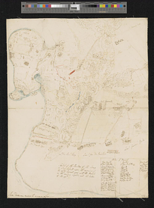
British troop dispositions in and near New York City
3.
British troop dispositions in and near New York City, July and August 1781
4.
British troop dispositions in and near New York City, Sept. 2d 1781
5.
Disposition of the British forces on Long Island, Staten Island, and Manhattan Island, under Cornwallis and Knyphausen
6.
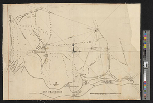
Long Island
7.
A new and accurate map of Connecticut and Rhode Island from the best authorities
8.
Part of the southwestern shore of Long Island
9.
Plan of Long Island in New York governement [sic] Nort [sic] America
10.
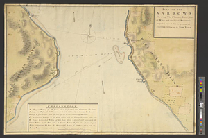
Plan of the narrows : shewing, the channel, shoal, depth of water, and the several battery's proposed on each side to prevent...
11.
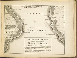
Plan of the narrows about 10 miles from New York
12.
Situation des posten zu Denyses Ferry auf Long Island wie solcher den 7ten October 1781 von furste : Braunshweig und Hessen...
13.
Sketch of the country illustrating the late engagement in Long Island
14.
Sketch of the position of the army on Long Island upon the morning of the 26th of August, 1776; with the march on the ensuing...
15.
15 lots of 440a each in Great Lot no. 4 of Macomb purchase : 6600 acres within 2 miles of the St. Lawrence Turnpike & 1/2 mile...
16.
The above is a connection of the three surveys which I have been able to make on Peters Creek, of yours to gether with John...
17.
An accurate map of Canada, with the adjacent countries; exhibiting the late seat of war between the English & French in those...
18.
An accurate map of New York in North America from a late survey
19.
An accurate map of the British empire in Nth. America as settled by the preliminaries in 1762
20.
An accurate map of the island of St. Christophers, from an actual survey; shewing the parishes, churches; and rivers; also the...
‹ Prev
Next ›
1
2
3
4
5
…
45
46


![Plan of Long Island in New York governement [sic] Nort [sic] America](https://bpldcassets.blob.core.windows.net/derivatives/metadata/commonwealth-oai:z890ws44r/image_thumbnail_300.jpg)