Toggle navigation
LMEC Home
Exhibitions
Georeferencing
Tools for Teachers
Collections
My Favorites
Sign Up / Log In
Search
Search the map portal
Map Collection
Map Collection
Map Sets
Search
Search
Search for
Search In
All Fields
Creator
Title
Subject
Place
Search All Digital Collections
Advanced Search
13680 Results
Filter your Search
Place
North and Central America
10,344
United States
8,475
Massachusetts
2,789
Suffolk (county)
1,677
Boston
1,633
Europe
1,415
Canada
950
New York
649
more
Place
»
Topic
Boston (Mass.)--Maps
747
City planning--Massachusetts--Boston--Maps
418
United States--History--Revolution, 1775-1783--Maps
329
United States--Maps
322
Real property--Massachusetts--Boston--Maps
254
Urban renewal--Massachusetts--Boston--Maps
254
Massachusetts--Maps
231
Insurance surveys
197
more
Topic
»
Date
Date range begin
–
Date range end
Current results range from
1482
to
2023
View distribution
Creator
United States. Hydrographic Office
597
Boston Redevelopment Authority
404
Des Barres, Joseph F. W. (Joseph Frederick Wallet), 1722-1824
247
Royal United Services Institute for Defence and Security Studies
160
Jefferys, Thomas, -1771
154
George, III, King of Great Britain, 1738-1820
152
George, IV, King of Great Britain, 1762-1830
151
O.H. Bailey & Co
148
more
Creator
»
Format
Maps/Atlases
13,499
Manuscripts
985
Prints
102
Books
49
Drawings/Illustrations
44
Photographs
15
Objects/Artifacts
13
Documents
7
more
Format
»
Georeferenced
Yes
979
No
12,701
Collection
Norman B. Leventhal Map & Education Center Collection
9,096
American Revolutionary War-Era Maps
3,305
Boston and New England Maps
2,915
Urban Maps
2,471
Maritime Charts and Atlases
1,169
William L. Clements Library Collection
910
Library of Congress Collection
618
Boston Redevelopment Authority Collection
475
more
Collection
»
Available to use
No known restrictions
10,246
Creative Commons license
1,678
Search Constraints
Sort by relevance
relevance
title
date (asc)
date (desc)
Number of results to display per page
20 per page
10
per page
20
per page
50
per page
100
per page
View results as:
grid view
map view
Search Results
12841.
Transportation lines between the United States and Mexico, showing differences of elevation
12842.
Transportation map of Manchoukuo
12843.
Transportation map of New York
12844.
Transylvania campaigne Oct. 1916 ; Macedonian campaigne ; Somme Campaigne Oct. 1916
12845.
Travelers' and shippers' railway guide map of Chicago
12846.
Traveler's rail road map of the United States to accompany "Boston to Washington" Riverside Series Centennial Guides
12847.
Traveller's map of the middle, northern, eastern states and Canada showing all the railroad, steamboat, canal, and principal...
12848.
The travellers; or, a tour through Europe
12849.
Travel-map of New England
12850.
Trees in Brookline, Massachusetts
12851.
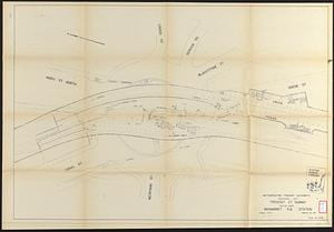
Tremont St. subway Boston, Mass. Haymarket Sq. Station
12852.
Trempaleau County, Wis.
12853.
Triangles on Mercator projection between St. Augustine and Cape Breton and St. Augustine and Cape Ortegal
12854.
Triangulacion de la provincia de Santa Fé
12855.
Tribal map of Morocco
12856.
Tri-state power map : Pennsylvania -- New York -- New Jersey
12857.
Tri-state trolley map showing Boston & Northern and Old Colony Street Railway Companies' systems and connecting lines
12858.
Trolley pathfinder birds eye map of interurban trolley lines in New England
12859.
Trolley wayfinder, birds eye view of trolley routes in New England
12860.
[Troops on parade, the Charles River and Castle Island]
‹ Prev
Next ›
1
2
…
639
640
641
642
643
644
645
646
647
…
683
684


![[Troops on parade, the Charles River and Castle Island]](https://bpldcassets.blob.core.windows.net/derivatives/images/commonwealth:dz010v69k/image_thumbnail_300.jpg)