Toggle navigation
LMEC Home
Exhibitions
Georeferencing
Tools for Teachers
Collections
My Favorites
Sign Up / Log In
Search
Search the map portal
Map Collection
Map Collection
Map Sets
Search
Search
Search for
Search In
All Fields
Creator
Title
Subject
Place
Search All Digital Collections
Advanced Search
13385 Results
Filter your Search
Place
North and Central America
10,111
United States
8,249
Massachusetts
2,691
Suffolk (county)
1,664
Boston
1,621
Europe
1,386
Canada
949
New York
640
more
Place
»
Topic
Boston (Mass.)--Maps
741
City planning--Massachusetts--Boston--Maps
418
United States--History--Revolution, 1775-1783--Maps
329
United States--Maps
315
Urban renewal--Massachusetts--Boston--Maps
254
Real property--Massachusetts--Boston--Maps
252
Massachusetts--Maps
219
Insurance surveys
197
more
Topic
»
Date
Date range begin
–
Date range end
Current results range from
1482
to
2023
View distribution
Creator
United States. Hydrographic Office
595
Boston Redevelopment Authority
403
Des Barres, Joseph F. W. (Joseph Frederick Wallet), 1722-1824
247
Royal United Services Institute for Defence and Security Studies
160
Jefferys, Thomas, -1771
154
George, III, King of Great Britain, 1738-1820
152
George, IV, King of Great Britain, 1762-1830
151
O.H. Bailey & Co
148
more
Creator
»
Format
Maps/Atlases
13,205
Manuscripts
985
Prints
102
Books
49
Drawings/Illustrations
44
Photographs
15
Objects/Artifacts
13
Documents
7
more
Format
»
Georeferenced
Yes
979
No
12,406
Collection
Norman B. Leventhal Map & Education Center Collection
8,891
American Revolutionary War-Era Maps
3,305
Boston and New England Maps
2,804
Urban Maps
2,397
Maritime Charts and Atlases
1,150
William L. Clements Library Collection
910
Library of Congress Collection
618
Boston Redevelopment Authority Collection
475
more
Collection
»
Available to use
No known restrictions
9,952
Creative Commons license
1,677
Search Constraints
Sort by relevance
relevance
title
date (asc)
date (desc)
Number of results to display per page
20 per page
10
per page
20
per page
50
per page
100
per page
View results as:
grid view
map view
Search Results
381.
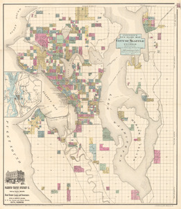
Anderson’s new guide map of the city of Seattle and environs
382.
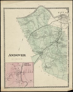
Andover
383.
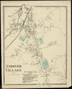
Andover Village : (Andover)
384.
Andrews's new and accurate travelling map of the roads of Scotland : shewing the distances between the towns &c
385.
Androscoggin Mills (Cotton Mill), Lewiston, Me. [insurance map]
386.
Androscoggin Mills "No. 5 Mill" formerly Avon Mfg. Co., Lewiston, Me. [insurance map]
387.
Anglesey : Wight Vectis olim ; Garnesay ; Iarsay
388.
Anglia Regnum
389.
Angling in troubled waters = der fischfang im truben = la peche en eau trouble = la pesca nelle acque turbes : a serio-comic...
390.
Anjou : Andegavensium ditionis vera et integra descriptio
391.
Annapolis Royal
392.
Annapolis Royal ... : St. Mary's Bay
393.
Annapolis Royal ; St. Mary's Bay
394.
Annapolis Royal ; St. Mary's Bay
395.
Annapolis Royal ; St. Mary's Bay
396.
Annexation map
397.
L'Anse including Portage Entry and part of Keweenaw Bay, Lake Superior
398.
Ansei kaisei Oedo ōezu = Map of Jeddo
399.
Anthony Burns
400.
Antietam
‹ Prev
Next ›
1
2
…
16
17
18
19
20
21
22
23
24
…
669
670

![Androscoggin Mills (Cotton Mill), Lewiston, Me. [insurance map]](https://bpldcassets.blob.core.windows.net/derivatives/images/commonwealth:4j03df194/image_thumbnail_300.jpg)
![Androscoggin Mills "No. 5 Mill" formerly Avon Mfg. Co., Lewiston, Me. [insurance map]](https://bpldcassets.blob.core.windows.net/derivatives/images/commonwealth:2r36vc17g/image_thumbnail_300.jpg)