Anderson’s new guide map of the city of Seattle and environs
Item Information
- Title:
- Anderson’s new guide map of the city of Seattle and environs
- Description:
-
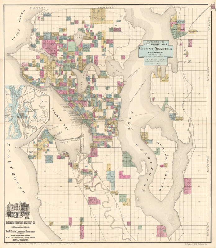
In the early 1850s, Seattle was founded on the banks of Elliott Bay in the present-day Pioneer Square district, and it was incorporated as a city in 1869. The city was established as a progressive and developing community, which began growing rapidly in the late 1880s as a result of the lumber industry, and later the Alaska Gold Rush, such that by 1890 its population reached 42,837. 1890 was an important year for Seattle, because it marked the year that the first transcontinental train arrived in the city. Railroad lines can be seen throughout this map, and they likely contributed to Seattle’s still greater population increase in later years. 1890 was also significant because it saw the beginning of a new and improved city. A fire in June of 1889 destroyed 116 acres of the city, which had consisted of predominantly wooden storefronts, log homes, and lumber mills. Seattle was rebuilt with brick, steel, and stone, and the new city was raised about a dozen feet above the old to prevent flooding. This map is a cadastral, or real-estate, map prepared for Eshelman, Llewellyn & Co. Investment Brokers, meaning that it shows the extent, value, and ownership of land, likely for taxation purposes. In addition to real-estate information, the map shows Seattle’s boundaries, ferry routes, cable and electric transit lines, and radial distances from the city center, seen at center left on the banks of Elliott Bay. It also includes an inset map of the area surrounding Seattle, with the city demarcated at the center with cross-hatching.
- Lithographer:
- Everts, L. H. (Louis H.)
- Cartographer:
- O.P. Anderson & Co.
- Date:
-
1890
- Format:
-
Maps/Atlases
- Location:
- MacLean Collection Map Library
- Collection (local):
-
MacLean Collection Map Library
- Subjects:
-
Seattle (Wash.)--Maps
- Places:
-
King (county)Seattle
- Extent:
- 1 map : color ; 82 cm x 59 cm
- Terms of Use:
-
Public Domain/No known restrictions on use. Contact host institution to download image.
Contact host institution for more information.
- Publisher:
-
Washington :
O.P. Anderson and Co.
- Language:
-
English
- Notes:
-
Inset: [Area map].
Lithograph.
- Identifier:
-
MacLeanColl_12352_Seattle
- Call #:
-
12352