Toggle navigation
LMEC Home
Exhibitions
Georeferencing
Tools for Teachers
Collections
My Favorites
Sign Up / Log In
Search
Search the map portal
Map Collection
Map Collection
Map Sets
Search
Search
Search for
Search In
All Fields
Creator
Title
Subject
Place
Search All Digital Collections
Advanced Search
13668 Results
Filter your Search
Place
North and Central America
10,334
United States
8,465
Massachusetts
2,784
Suffolk (county)
1,677
Boston
1,633
Europe
1,413
Canada
950
New York
649
more
Place
»
Topic
Boston (Mass.)--Maps
747
City planning--Massachusetts--Boston--Maps
418
United States--History--Revolution, 1775-1783--Maps
329
United States--Maps
321
Real property--Massachusetts--Boston--Maps
254
Urban renewal--Massachusetts--Boston--Maps
254
Massachusetts--Maps
231
Insurance surveys
197
more
Topic
»
Date
Date range begin
–
Date range end
Current results range from
1482
to
2023
View distribution
Creator
United States. Hydrographic Office
597
Boston Redevelopment Authority
404
Des Barres, Joseph F. W. (Joseph Frederick Wallet), 1722-1824
247
Royal United Services Institute for Defence and Security Studies
160
Jefferys, Thomas, -1771
154
George, III, King of Great Britain, 1738-1820
152
George, IV, King of Great Britain, 1762-1830
151
O.H. Bailey & Co
148
more
Creator
»
Format
Maps/Atlases
13,487
Manuscripts
985
Prints
102
Books
49
Drawings/Illustrations
44
Photographs
15
Objects/Artifacts
13
Documents
7
more
Format
»
Georeferenced
Yes
979
No
12,689
Collection
Norman B. Leventhal Map & Education Center Collection
9,088
American Revolutionary War-Era Maps
3,305
Boston and New England Maps
2,909
Urban Maps
2,465
Maritime Charts and Atlases
1,169
William L. Clements Library Collection
910
Library of Congress Collection
618
Boston Redevelopment Authority Collection
475
more
Collection
»
Available to use
No known restrictions
10,235
Creative Commons license
1,677
Search Constraints
Sort by relevance
relevance
title
date (asc)
date (desc)
Number of results to display per page
20 per page
10
per page
20
per page
50
per page
100
per page
View results as:
grid view
map view
Search Results
5001.
Map of Boston, for 1885
5002.
Map of Boston, for 1886
5003.
Map of Boston, for 1887
5004.
Map of Boston, for 1888
5005.
Map of Boston, for 1889
5006.
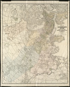
Map of Boston from the latest surveys
5007.
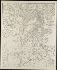
Map of Boston from the latest surveys
5008.
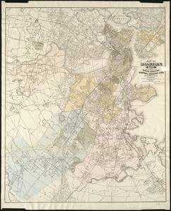
Map of Boston from the latest surveys
5009.
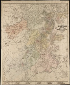
Map of Boston from the latest surveys
5010.
Map of Boston from the latest surveys
5011.
Map of Boston from the latest surveys
5012.
Map of Boston Harbor : showing commissioners' lines, wharves &c
5013.
Map of Boston Harbor
5014.
Map of Boston in the state of Massachusetts
5015.
Map of Boston in the state of Massachusetts
5016.
Map of Boston inner harbor
5017.
Map of Boston inner harbor to accompany report under chapter 93, resolves of 1907, December 1, 1907
5018.
Map of Boston naval shipyard, Boston, Mass. showing conditions on Jan. 1, 1966
5019.
Map of Boston postal stations
5020.
Map of Boston proper
‹ Prev
Next ›
1
2
…
247
248
249
250
251
252
253
254
255
…
683
684