Toggle navigation
LMEC Home
Exhibitions
Georeferencing
Tools for Teachers
Collections
My Favorites
Sign Up / Log In
Search
Search the map portal
Map Collection
Map Collection
Map Sets
Search
Search
Search for
Search In
All Fields
Creator
Title
Subject
Place
Search All Digital Collections
Advanced Search
2843 Results
My Search
Start Over
atlas
Remove constraint atlas
Filter your Search
Place
North and Central America
1,647
United States
987
Europe
464
Massachusetts
348
Canada
271
Asia
190
South America
189
Suffolk (county)
163
more
Place
»
Topic
Landowners--Massachusetts--Boston--Maps
115
Real property--Massachusetts--Boston--Maps
106
United States--Maps
87
Boston (Mass.)--Maps
63
United States--History--French and Indian War, 1754-1763--Maps
63
Saint Lawrence River--Maps
41
Nautical charts--Early works to 1800
39
North America--Maps--Early works to 1800
36
more
Topic
»
Date
Date range begin
–
Date range end
Current results range from
1482
to
2023
View distribution
Creator
United States. Hydrographic Office
582
Des Barres, Joseph F. W. (Joseph Frederick Wallet), 1722-1824
118
Ptolemy, 2nd cent
100
Bromley, George Washington
99
Bromley, Walter Scott
97
G.W. Bromley & Co.
75
Carey, Mathew, 1760-1839
74
Paullin, Charles Oscar, 1868 or 1869-1944
70
more
Creator
»
Format
Maps/Atlases
2,827
Manuscripts
58
Books
37
Prints
8
Documents
5
Drawings/Illustrations
1
Georeferenced
Yes
142
No
2,701
Collection
Norman B. Leventhal Map & Education Center Collection
2,386
Maritime Charts and Atlases
1,150
American Revolutionary War-Era Maps
504
Boston and New England Maps
374
Urban Maps
250
Massachusetts Real Estate Atlases
144
William L. Clements Library Collection
92
Mapping Boston Collection
61
more
Collection
»
Available to use
No known restrictions
2,292
Creative Commons license
158
Search Constraints
Sort by relevance
relevance
title
date (asc)
date (desc)
Number of results to display per page
20 per page
10
per page
20
per page
50
per page
100
per page
View results as:
grid view
map view
Search Results
1201.
France, Mediterranean coast : from the Pilote Français 1842 ; republication of Brit. Admty. chart no. 2607, with additions &...
1202.
France, Mediterranean coast : from the Pilote Français 1842 ; republication of Brit. Admty. chart no. 2604, with additions &...
1203.
France, Mediterranean coast : from the Pilote Français 1843 ; republication of Brit. Admty. chart no. 2606, with additions and...
1204.
France, Mediterranean coast : from the Pilote Français 1842 ; republication of Brit. Admty. chart no. 2603, with additions and...
1205.
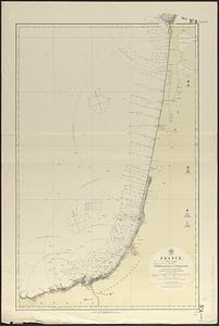
France, north west coast : from the Pilote Français 1823 ; republication of Brit. Admty. chart no. 2644, corrected to 1876
1206.
France, north west coast, Rade de la Hougue : from a French survey in 1833 ; republication of Brit. Admty. chart no. 2743, with...
1207.
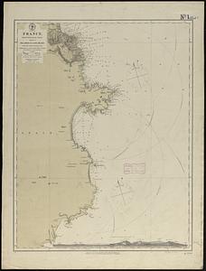
France, west coast
1208.
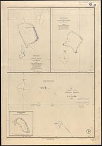
Funafuti or Ellice Island ; Nukufetau or De Peysters Island ; Ellice Group ; Nukulailai (Mitchell I.) from a sketch by Captain...
1209.
Funafuti or Ellices Island ; Nukufetau or De Peysters Island ; De Peysters Group
1210.
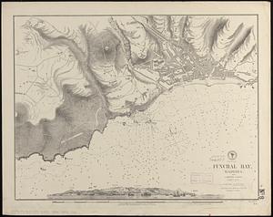
Funchal Bay, Madeira : from a British survey, corrected to 1871
1211.
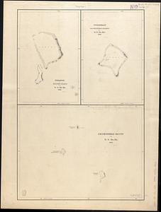
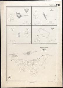
Gardner's or Kemins Island, Phœnix Group ; Flint's Island ; McKeans Island, Phœnix Group ; Maro Reef ; Lahaina Roads, Island of...
1212.
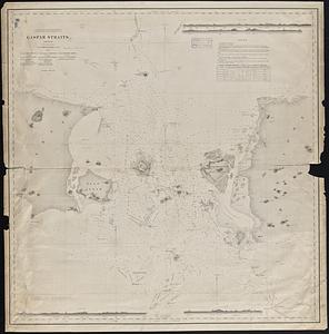
Gaspar Straits
1213.
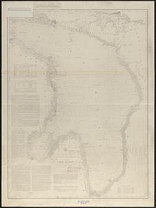
General chart of Lake Huron
1214.
A general chart of the Indian and part of the Pacific Oceans, shewing the various passages to & from China, Australia, New...
1215.
A general chart of the West Indies, including the Gulf of Mexico, with an enlarged plan of the island of Jamaica, also...
1216.
A generall chart of the western ocean
1217.
Gente Hermosa or Swains Island ; Jarvis' Island ; Birnies Island, Phœnix Group ; Enderbury' Island, Phœnix Group ; Hull's...
1218.
The Great Bahama Bank from Great Exuma Id. to New Providence Id.
1219.
The Great Bahama Bank, from Great Isaac to 23°40' N latitude
1220.
The Great Bahama Bank, from Old Bahama Channel to Exuma
‹ Prev
Next ›
1
2
…
57
58
59
60
61
62
63
64
65
…
142
143