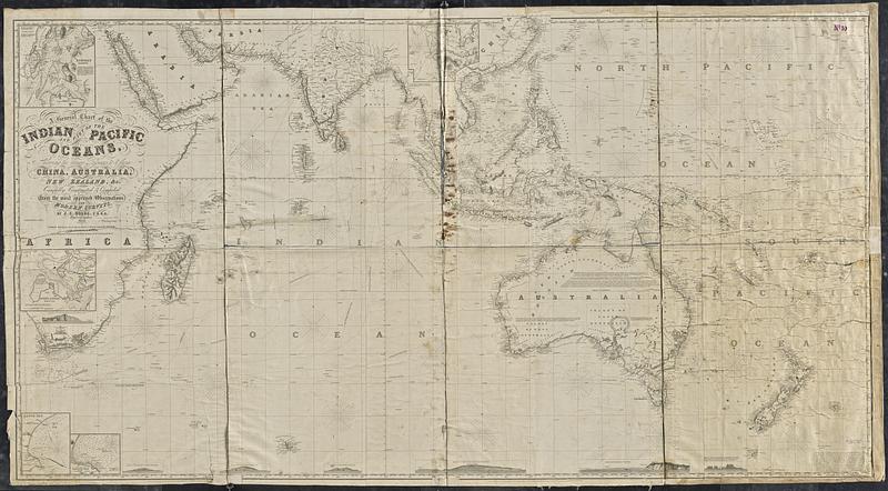
A general chart of the Indian and part of the Pacific Oceans, shewing the various passages to & from China, Australia, New Zealand, &c.
Item Information
- Title:
- A general chart of the Indian and part of the Pacific Oceans, shewing the various passages to & from China, Australia, New Zealand, &c.
- Cartographer:
- Hobbs, J. S. (John Stratton)
- Publisher:
- Wilson, Charles, active 1888
- Name on Item:
-
carefully constructed & compiled from the most approved observations and modern surveys, by J.S. Hobbs, F.R.G.S. Hydrographer
- Date:
-
1857
- Format:
-
Maps/Atlases
- Genre:
-
Nautical charts
- Location:
-
Boston Public Library
Norman B. Leventhal Map & Education Center - Collection (local):
-
Norman B. Leventhal Map & Education Center Collection
- Subjects:
-
Australasia--Maps
Indian Ocean--Maps
Pacific Ocean--Maps
Asia--Maps
Nautical charts--Australasia
Nautical charts--Asia
- Places:
-
Australasia (area)
Asia
Indian Ocean
Pacific Ocean
- Extent:
- 1 map ; 105 x 196 cm
- Terms of Use:
-
No known copyright restrictions.
No known restrictions on use.
- Publisher:
-
London :
Published as the Act directs, March 1st 1850, by Charles Wilson (late J.W. Norie & Wilson) at the Navigation Warehouse and Naval Academy No. 157 Leadenhall Street
- Scale:
-
Scale approximately 1:10,000,000 at equator
- Language:
-
English
- Notes:
-
Relief shown by hachures. Depths shown by soundings.
"Additions 1857."
Insets: Bombay Harbour -- [Hong Kong] -- Port Louis, Mauritius -- Algoa Bay -- Anchorage at Simon's Bay.
Includes notes, 7 coastal views and illustration of C. Agulhas lighthouse.
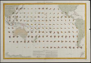
Also shows ship tracks.
Includes manuscript ship tracks, and dates and locations of whale encounters in pencil.
- Notes (citation):
-
Tooley, R.V. Printed maps of Australia, 717
- Identifier:
-
06_01_015439
- Call #:
-
G9181.P5 1857 .H63
- Barcode:
-
39999085936068