Toggle navigation
LMEC Home
Exhibitions
Georeferencing
Tools for Teachers
Collections
My Favorites
Sign Up / Log In
Search
Search the map portal
Map Collection
Map Collection
Map Sets
Search
Search
Search for
Search In
All Fields
Creator
Title
Subject
Place
Search All Digital Collections
Advanced Search
13385 Results
Filter your Search
Place
North and Central America
9,353
United States
7,078
Suffolk (county)
1,664
Boston
1,621
Europe
1,035
Canada
949
Massachusetts
794
New York
532
more
Place
»
Topic
Boston (Mass.)--Maps
741
City planning--Massachusetts--Boston--Maps
418
United States--History--Revolution, 1775-1783--Maps
329
United States--Maps
315
Urban renewal--Massachusetts--Boston--Maps
254
Real property--Massachusetts--Boston--Maps
252
Massachusetts--Maps
219
Insurance surveys
197
more
Topic
»
Date
Date range begin
–
Date range end
Current results range from
1482
to
2023
View distribution
Creator
United States. Hydrographic Office
595
Boston Redevelopment Authority
403
Des Barres, Joseph F. W. (Joseph Frederick Wallet), 1722-1824
247
Royal United Services Institute for Defence and Security Studies
160
Jefferys, Thomas, -1771
154
George, III, King of Great Britain, 1738-1820
152
George, IV, King of Great Britain, 1762-1830
151
O.H. Bailey & Co
148
more
Creator
»
Format
Maps/Atlases
13,205
Manuscripts
985
Prints
102
Books
49
Drawings/Illustrations
44
Photographs
15
Objects/Artifacts
13
Documents
7
more
Format
»
Georeferenced
Yes
979
No
12,406
Collection
Norman B. Leventhal Map Center Collection
8,891
American Revolutionary War-Era Maps
3,305
Boston and New England Maps
2,804
Urban Maps
2,397
Maritime Charts and Atlases
1,150
William L. Clements Library Collection
910
Library of Congress Collection
618
Boston Redevelopment Authority Collection
475
more
Collection
»
Available to use
No known restrictions
9,952
Creative Commons license
1,677
Search Constraints
Sort by relevance
relevance
title
date (asc)
date (desc)
Number of results to display per page
20 per page
10
per page
20
per page
50
per page
100
per page
View results as:
grid view
map view
Search Results
6181.
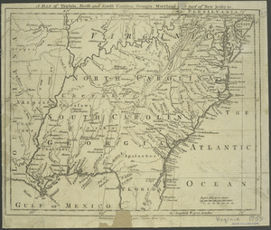
A map of Virginia, North and South Carolina, Georgia, Maryland : with part of New Jersey &c
6182.
Map of Virginia, West Virginia and Ohio : showing Norfolk and Western Railway : main line branches and connections
6183.
[Map of W. Dall's lots in Athens County, Washington County, and Gallia County, Ohio]
6184.
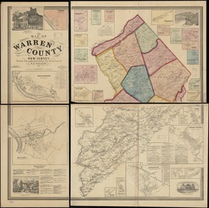
Map of Warren County, New Jersey
6185.
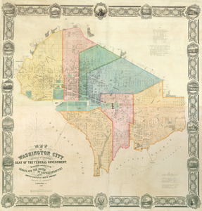
Map of Washington City
6186.
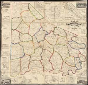
Map of Washington Co., Pennsylvania : from actual surveys
6187.
Map of Washington County, Ohio
6188.
Map of Washington County, Vermont
6189.
Map of Webster Lake, Franklin, N.H
6190.
A map of West Florida and part of Et: Florida, Georgia part of So: Carolina i[n]cluding [torn] & Chactaw, Chickasaw & Creek...
6191.
[Map of West Florida and the Mississippi River] : John Campbell
6192.
Map of West Roxbury
6193.
Map of West Virginia showing coal, oil, gas and limestone areas
6194.
Map of West Virginia showing railroads and county products
6195.
A map of Westborough
6196.
Map of Westborough Mass
6197.
Map of White Pass & Yukon Route and connections
6198.
Map of Whitley County
6199.
Map of Wisconsin showing geology and roads
6200.
Map of Wiskonsin Territory, compiled from the public surveys
‹ Prev
Next ›
1
2
…
306
307
308
309
310
311
312
313
314
…
669
670

![[Map of W. Dall's lots in Athens County, Washington County, and Gallia County, Ohio]](https://bpldcassets.blob.core.windows.net/derivatives/images/commonwealth:w9505s00n/image_thumbnail_300.jpg)

![A map of West Florida and part of Et: Florida, Georgia part of So: Carolina i[n]cluding [torn] & Chactaw, Chickasaw & Creek nations with [torn] [r]oad [torn] Pensacola through ye: Creek nation to Augusitus & Charlestown](https://bpldcassets.blob.core.windows.net/derivatives/metadata/commonwealth-oai:v98001375/image_thumbnail_300.jpg)
![[Map of West Florida and the Mississippi River]](https://bpldcassets.blob.core.windows.net/derivatives/images/commonwealth:hx11z2898/image_thumbnail_300.jpg)


