Toggle navigation
LMEC Home
Exhibitions
Georeferencing
Tools for Teachers
Collections
My Favorites
Sign Up / Log In
Search
Search the map portal
Map Collection
Map Collection
Map Sets
Search
Search
Search for
Search In
All Fields
Creator
Title
Subject
Place
Search All Digital Collections
Advanced Search
13436 Results
Filter your Search
Place
North and Central America
10,161
United States
8,299
Massachusetts
2,739
Suffolk (county)
1,667
Boston
1,623
Europe
1,386
Canada
949
New York
640
more
Place
»
Topic
Boston (Mass.)--Maps
742
City planning--Massachusetts--Boston--Maps
418
United States--History--Revolution, 1775-1783--Maps
329
United States--Maps
315
Urban renewal--Massachusetts--Boston--Maps
254
Real property--Massachusetts--Boston--Maps
252
Massachusetts--Maps
228
Insurance surveys
197
more
Topic
»
Date
Date range begin
–
Date range end
Current results range from
1482
to
2023
View distribution
Creator
United States. Hydrographic Office
595
Boston Redevelopment Authority
403
Des Barres, Joseph F. W. (Joseph Frederick Wallet), 1722-1824
247
Royal United Services Institute for Defence and Security Studies
160
Jefferys, Thomas, -1771
154
George, III, King of Great Britain, 1738-1820
152
George, IV, King of Great Britain, 1762-1830
151
O.H. Bailey & Co
148
more
Creator
»
Format
Maps/Atlases
13,255
Manuscripts
985
Prints
102
Books
49
Drawings/Illustrations
44
Photographs
15
Objects/Artifacts
13
Documents
7
more
Format
»
Georeferenced
Yes
979
No
12,457
Collection
Norman B. Leventhal Map & Education Center Collection
8,942
American Revolutionary War-Era Maps
3,305
Boston and New England Maps
2,854
Urban Maps
2,402
Maritime Charts and Atlases
1,150
William L. Clements Library Collection
910
Library of Congress Collection
618
Boston Redevelopment Authority Collection
475
more
Collection
»
Available to use
No known restrictions
10,003
Creative Commons license
1,677
Search Constraints
Sort by relevance
relevance
title
date (asc)
date (desc)
Number of results to display per page
20 per page
10
per page
20
per page
50
per page
100
per page
View results as:
grid view
map view
Search Results
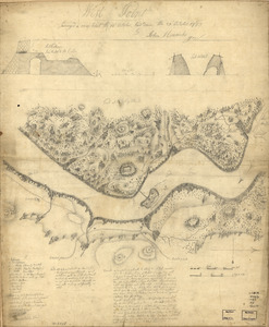
13261.
West Point : surveyed a coup d'oeil the 24th October, laid down the 27th October 1783
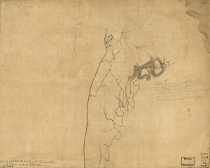
13262.
West Point and the Hudson River
13263.
West Point and vicinity
13264.
West Point, New York
13265.
West Point; or Fort Defiance
13266.
West Randolph, Vt : 1886
13267.
West Roxbury Park : West Roxbury district
13268.
West Wood Island Park, East Boston district
13269.
Westboro, Mass., 1880
13270.
Westborough, Massachusetts, 1888
13271.
Westchester County coast, New Rochelle to Horseneck River: unfinished
13272.
Western division of Paris, containing the quartiers; Eastern division of Paris, containing the quartiers
13273.
Western Front (British & German attacks)
13274.
Western hemisphere
13275.
The Western Hemisphere from the latest discoveries
13276.
Western Massachusetts closed to the public
13277.
Western Massachusetts open space abounds
13278.
Western part of the United States of America including all its newly acquired territory
13279.
Western route, from Boston to Michigan, Ohio and Indiana ; Southern route, from Boston to Wilmington and Red Clay ; S. Western...
13280.
Western shore of Jesus Island and Mille Îles River
‹ Prev
Next ›
1
2
…
660
661
662
663
664
665
666
667
668
…
671
672