Toggle navigation
LMEC Home
Exhibitions
Georeferencing
Tools for Teachers
Collections
My Favorites
Sign Up / Log In
Search
Search the map portal
Map Collection
Map Collection
Map Sets
Search
Search
Search for
Search In
All Fields
Creator
Title
Subject
Place
Search All Digital Collections
Advanced Search
10951 Results
My Search
Start Over
All Fields
americas
Remove constraint All Fields: americas
Filter your Search
Place
North and Central America
10,344
United States
8,469
Massachusetts
2,789
Suffolk (county)
1,675
Boston
1,631
Canada
937
New York
649
Middlesex (county)
441
more
Place
»
Topic
Boston (Mass.)--Maps
746
City planning--Massachusetts--Boston--Maps
418
United States--History--Revolution, 1775-1783--Maps
327
United States--Maps
320
Real property--Massachusetts--Boston--Maps
254
Urban renewal--Massachusetts--Boston--Maps
254
Massachusetts--Maps
231
Insurance surveys
194
more
Topic
»
Date
Date range begin
–
Date range end
Current results range from
1507
to
2023
View distribution
Creator
Boston Redevelopment Authority
404
United States. Hydrographic Office
366
Des Barres, Joseph F. W. (Joseph Frederick Wallet), 1722-1824
197
Jefferys, Thomas, -1771
150
George, III, King of Great Britain, 1738-1820
146
O.H. Bailey & Co
146
George, IV, King of Great Britain, 1762-1830
145
Royal United Services Institute for Defence and Security Studies
139
more
Creator
»
Format
Maps/Atlases
10,828
Manuscripts
916
Prints
60
Books
43
Drawings/Illustrations
43
Photographs
15
Objects/Artifacts
7
Posters
3
more
Format
»
Georeferenced
Yes
823
No
10,128
Collection
Norman B. Leventhal Map & Education Center Collection
6,627
American Revolutionary War-Era Maps
3,123
Boston and New England Maps
2,912
Urban Maps
2,289
William L. Clements Library Collection
892
Maritime Charts and Atlases
816
Library of Congress Collection
552
Boston Redevelopment Authority Collection
475
more
Collection
»
Available to use
No known restrictions
7,767
Creative Commons license
1,541
Search Constraints
Sort by relevance
relevance
title
date (asc)
date (desc)
Number of results to display per page
20 per page
10
per page
20
per page
50
per page
100
per page
View results as:
grid view
map view
Search Results
10801.
Part of the modern counties of Union, Middlesex, and Somerset, New Jersey and Staten Island, New York
10802.
Part of the modern counties of Union, Middlesex, and Somerset, New Jersey and Staten Island, New York
10803.
Pend Oreille National Forest, Idaho
10804.
Plan of location of projected ship canal from Taunton River to Boston Harbor, through Weymouth Fore River ... Frank W. Hodgdon,...
10805.
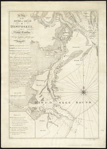
A plan of the river and sound of D'Awfoskee in South Carolina
10806.
A plan of the settled part of Canada reduced from the large survey made in the years 1760 & 1761 by order of General Murray...
10807.
Plan of the siege of Louisbourg in 1758, carry'd on by the British army commanded by His Excellency Major General Amherst, and...
10808.
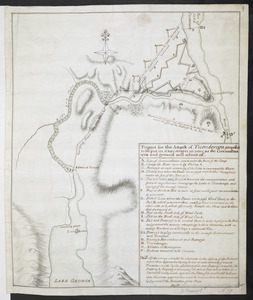
Project for the Attack of Ticonderoga, proposed to be put in executino as near as the circumstances and ground will admit of
10809.
Rochester, N.H : Gonic and East-Rochester, 1884
10810.
Ruatan or Rattan
10811.
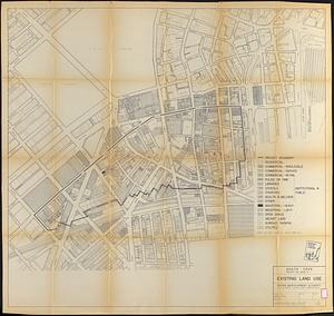
South Cove project no. Mass r- : existing land use
10812.
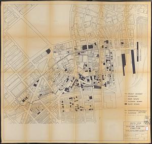
South Cove project no. Mass. r- : existing building condition
10813.
St. Stephen, New Brunswick and Calais, Maine : 1889
10814.
The strangers mercantile guide map of the cities of New York, Brooklyn, Jersey City, Hoboken, etc
10815.
Wakes Island ; Vatoa or Turtle Island and Vuata Vatoa ; Taloo Harbour, Island of Eimeo
10816.
West Indies, Guadeloupe, approaches to Pointe á Pitre : from a French survey in 1867, corrected to 1882
10817.
Aleutian Archipelago
10818.
Atlas of the county of Suffolk, Massachusetts : vol. 2nd late city of Roxbury, now wards 13-14 and 15, city of Boston
10819.
Carte Du Lac ontario nouvellement Rellevé avec ces port a grand pois a bitté Lescadre Engloisse & francoisse Leur gremant...
10820.
Carte générale des États-Unis de l'Amérique avec les plans des principales villes
‹ Prev
Next ›
1
2
…
537
538
539
540
541
542
543
544
545
…
547
548