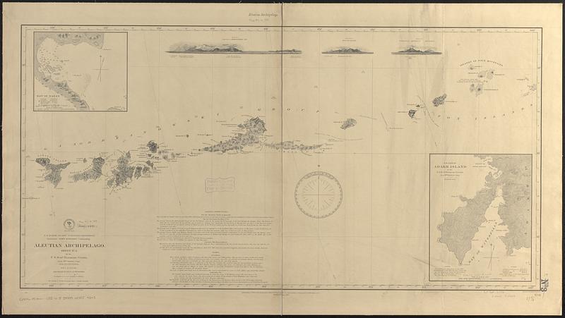
Aleutian Archipelago
Item Information
- Title:
- Aleutian Archipelago
- Issuing body:
- United States. Hydrographic Office
- Surveyor:
- United States North Pacific Exploring Expedition (1853-1856)
- Cartographer:
- Gibson, Wm. (William), Lieut.
- Surveyor:
- Kennon, Beverley, Lieut.
- Draftsman:
- Waldecker, Louis
- Engraver:
- McClelland, D.
- Name on Item:
-
by the U.S. Schr. Fenimore Cooper, Lieut. Wm. Gibson, comg., Lieut. Beverley Kennon, July & August 1855, and from Russian authorities ; projected by Lt. Wm. Gibson ; drawn by L. Waldecker ; views from sketches by Lt. Gibson and Paymaster W.B. Boggs ; eng. by D. McClelland
- Date:
-
[1887]
- Format:
-
Maps/Atlases
- Genre:
-
Nautical charts
- Location:
-
Boston Public Library
Norman B. Leventhal Map & Education Center - Collection (local):
-
Norman B. Leventhal Map & Education Center Collection
- Subjects:
-
Aleutian Islands (Alaska)--Maps
Nazan Bay (Alaska)--Maps
Adak Island (Alaska)--Maps
Nautical charts--Alaska--Nazan Bay
United States North Pacific Exploring Expedition (1853-1856)
- Places:
-
AlaskaAleutian Islands (area)
AlaskaAleutians West (area)Nazan Bay
AlaskaAdak Island (island)Andreanof Islands (area)
- Extent:
- 1 map ; 48 x 97 cm
- Terms of Use:
-
No known copyright restrictions.
No known restrictions on use.
- Publisher:
-
Washington, D.C. :
Hydrographic Office
- Edition:
- Edition of June 1887
- Scale:
-
Scale approximately 1:700,000
- Language:
-
English
- Notes:
-
Relief shown by hachures and spot heights. Depths shown by soundings.
Includes sailing directions, notes, 2 insets and 3 coastal views.
Insets: Bay of Nazan -- S.w. part of Adakh Island.
- Notes (date):
-
This date is inferred.
- Identifier:
-
06_01_017109
- Call #:
-
G9096.P5 svar .U55 no. 8
- Barcode:
-
39999085954343