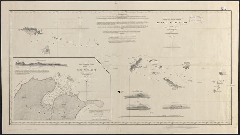
Aleutian Archipelago
Item Information
- Title:
- Aleutian Archipelago
- Issuing body:
- United States North Pacific Exploring Expedition (1853-1856)
- Cartographer:
- Gibson, Wm. (William), Lieut.
- Surveyor:
- Kennon, Beverley, Lieut.
- Draftsman:
- Mahon, Charles
- Illustrator:
- Kern, Edward Meyer, 1823-1863
- Engraver:
- Siebert, Selmar
- Name on Item:
-
by the U.S. Schr. Fenimore Cooper, Lieut. Wm. Gibson, comg., Lieut. Beverley Kennon, July & August 1855, and from Russian authorities ; projected by Lt. Wm. Gibson ; drawn by Charles Mahon ; views by Edwd. M. Kern from sketches by Lt. Gibson ; engr. by Selmar Siebert
- Date:
-
[1855?]
- Format:
-
Maps/Atlases
- Genre:
-
Nautical charts
- Location:
-
Boston Public Library
Norman B. Leventhal Map & Education Center - Collection (local):
-
Norman B. Leventhal Map & Education Center Collection
- Subjects:
-
Aleutian Islands (Alaska)--Maps
Chichagof Harbor (Alaska)--Maps
Nautical charts--Alaska--Chichagof Harbor
- Places:
-
AlaskaAleutian Islands (area)
AlaskaAleutians West (area)Chichagof Harbor (bay)
- Extent:
- 1 map ; 49 x 98 cm
- Terms of Use:
-
No known copyright restrictions.
No known restrictions on use.
- Publisher:
-
[Washington, D.C.] :
U.S. North Pacific Surveying Expedition
- Scale:
-
Scale approximately 1:700,000
- Language:
-
English
- Notes:
-
Relief shown by hachures and spot heights. Depths shown by soundings.
Includes sailing directions, notes, 1 inset and 5 coastal views.
Inset: Harbor of Tschitschagoff / by the U.S. Schr. Fenimore Cooper, Lieut. Wm. Gibson comg., July 1855.
- Identifier:
-
06_01_017463
- Call #:
-
G4372.A4 1855 .U55
- Barcode:
-
39999085966065


