Toggle navigation
LMEC Home
Exhibitions
Georeferencing
Tools for Teachers
Collections
My Favorites
Sign Up / Log In
Search
Search the map portal
Map Collection
Map Collection
Map Sets
Search
Search
Search for
Search In
All Fields
Creator
Title
Subject
Place
Search All Digital Collections
Advanced Search
10951 Results
My Search
Start Over
All Fields
americas
Remove constraint All Fields: americas
Filter your Search
Place
North and Central America
10,344
United States
8,469
Massachusetts
2,789
Suffolk (county)
1,675
Boston
1,631
Canada
937
New York
649
Middlesex (county)
441
more
Place
»
Topic
Boston (Mass.)--Maps
746
City planning--Massachusetts--Boston--Maps
418
United States--History--Revolution, 1775-1783--Maps
327
United States--Maps
320
Real property--Massachusetts--Boston--Maps
254
Urban renewal--Massachusetts--Boston--Maps
254
Massachusetts--Maps
231
Insurance surveys
194
more
Topic
»
Date
Date range begin
–
Date range end
Current results range from
1507
to
2023
View distribution
Creator
Boston Redevelopment Authority
404
United States. Hydrographic Office
366
Des Barres, Joseph F. W. (Joseph Frederick Wallet), 1722-1824
197
Jefferys, Thomas, -1771
150
George, III, King of Great Britain, 1738-1820
146
O.H. Bailey & Co
146
George, IV, King of Great Britain, 1762-1830
145
Royal United Services Institute for Defence and Security Studies
139
more
Creator
»
Format
Maps/Atlases
10,828
Manuscripts
916
Prints
60
Books
43
Drawings/Illustrations
43
Photographs
15
Objects/Artifacts
7
Posters
3
more
Format
»
Georeferenced
Yes
823
No
10,128
Collection
Norman B. Leventhal Map & Education Center Collection
6,627
American Revolutionary War-Era Maps
3,123
Boston and New England Maps
2,912
Urban Maps
2,289
William L. Clements Library Collection
892
Maritime Charts and Atlases
816
Library of Congress Collection
552
Boston Redevelopment Authority Collection
475
more
Collection
»
Available to use
No known restrictions
7,767
Creative Commons license
1,541
Search Constraints
Sort by relevance
relevance
title
date (asc)
date (desc)
Number of results to display per page
20 per page
10
per page
20
per page
50
per page
100
per page
View results as:
grid view
map view
Search Results
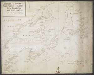
10721.
A CHART of the COAST OF NEWFOUND-LAND NEW SCOTLAND NEW ENGLAND &c. 1711
10722.
A chart of the North-American coast, for the navigation between Halifax and Philadelphia
10723.
The city of New York as laid out by the Commissioners with the surrounding country
10724.
Crow Harbor, on the south shore of Chedabuctou Bay
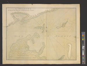
10725.
A draught of Ship & Catt islands and the opposite coast
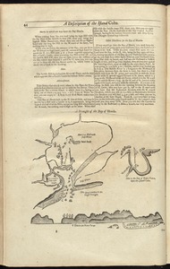
10726.
A draught of the Bay of Honda
10727.
A draught of the river Missisippi. From the Balise to Fort Cavendish : taken in the months of June, July, August, September,...
10728.
Fishing grounds out of Boston : NLSECO marine diesel oil engines ; built by New London Ship & Engine Co., Groton, Conn
10729.
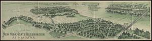
Guide of the New York State Reservation at Niagara
10730.
Hudson's River from Stony Pt. to Fort Montgomery
10731.
Infrastructure around Tobin Bridge/US route 1 in Charlestown
10732.
Klamath project, Oregon-California
10733.
Landscaping plan of City Hall Plaza, Boston
10734.
Lemhi National Forest, Idaho
10735.
Map exhibiting the Farmington & Hampshire & Hampden canals : together with the line of their proposed continuation through the...
10736.
Map of Chickamauga & Chattanooga National Park
10737.
[Map of Saint Simons and Jekyll Islands]
10738.
[Map of Saint Simons and Jekyll Islands with fortifications]
10739.
Map of the cities of Boston, Cambridge, Somerville and Chelsea, and the town of Brookline with parts of Newton, Malden and...
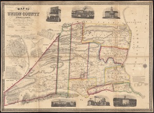
10740.
Map of Union County, Pennsylvania : entirely from original surveys
‹ Prev
Next ›
1
2
…
533
534
535
536
537
538
539
540
541
…
547
548


![[Map of Saint Simons and Jekyll Islands]](https://bpldcassets.blob.core.windows.net/derivatives/images/commonwealth:hx11z454k/image_thumbnail_300.jpg)
![[Map of Saint Simons and Jekyll Islands with fortifications]](https://bpldcassets.blob.core.windows.net/derivatives/images/commonwealth:hx11z4564/image_thumbnail_300.jpg)