Arlington, Massachusetts : 1884
Item Information
- Title:
- Arlington, Massachusetts : 1884
- Description:
-
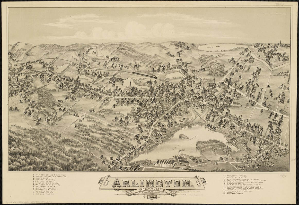
In this composition, Arlington is viewed from the south looking north across the center of the village to Mystic Pond on the horizon. The town appears at the height of its industrial activity and as it is beginning to become a residential suburb of Cambridge and Boston. The legend identifies twenty-seven prominent structures, including six churches and eight industrial activities. Almost all the churches and the town hall, with the height of their spires exaggerated, were located in the center of the drawing, focusing attention on the residential portion of the community. Spy Pond, appearing in the center foreground, was the location of Arlington's most important industry during the middle of the 19th century the cutting and shipping of ice primarily for use in the Caribbean trade. Gage's Ice Houses were situated at three different locations around the pond, while the Woods Ice Tool Manufacture was located nearby. The other six industries, recognizable by their tall smoke stacks, produced a variety of goods. They were located near mill ponds on a small stream flowing into Mystic Pond. Known as Menotomy throughout the colonial period, Arlington was originally settled in 1635, as a village within the town of Cambridge. It saw extensive military action as the British retreated from neighboring Concord and Lexington to Boston in the opening battle of the Revolutionary War. In 1807, it was incorporated as a separate town, first called West Cambridge, but was renamed Arlington in 1867 in honor of the soldiers buried at Arlington National Cemetery.
- Creator:
- O.H. Bailey & Co
- Date:
-
1884
- Format:
-
Maps/Atlases
- Location:
-
Boston Public Library
Norman B. Leventhal Map & Education Center - Collection (local):
-
Norman B. Leventhal Map & Education Center Collection
- Subjects:
-
Arlington (Mass.)--Aerial views
- Places:
-
MassachusettsMiddlesex (county)Arlington
- Extent:
- 1 view ; 43 x 73 cm.
- Terms of Use:
-
No known copyright restrictions.
No known restrictions on use.
- Publisher:
-
Boston :
O.H. Bailey
- Scale:
-
Not drawn to scale.
- Language:
-
English
- Notes:
-
Indexed for points of interest.
Bird's-eye view.
- Notes (exhibitions):
-
Exhibited: "Boston & Beyond: A Bird’s Eye View of New England" organized by the Norman B. Leventhal Map Center at the Boston Public Library, 2008.
- Identifier:
-
06_01_001825
- Call #:
-
G3764.A7A3 1884 .O43
- Barcode:
-
39999058993203


