Quincy, Mass
Item Information
- Title:
- Quincy, Mass
- Description:
-
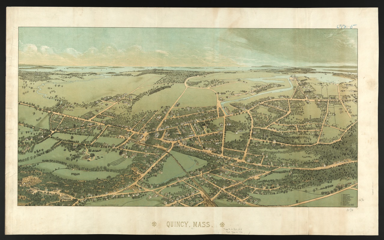
One year after Whitefield completed the Dedham view, he published this bird's eye view of Quincy, a nearby town also in Norfolk County. While this view is almost as unadorned as the Dedham view, it was a little more promotional in that it included a legend identifying thirteen important buildings. There were no insets of important structures, but the streets were labeled. Like Dedham, Quincy is depicted as a quiet, country village. An extensive rural landscape lies between the village and the bay, fading into the horizon. The buildings Whitefield chooses to identify include the town hall, five churches, four schools, and the birthplaces of John and John Quincy Adams. Although he did not identify any industries, there is some evidence of the towns economy. The granite quarries, for which Quincy was noted, are visible in the lower left corner at the end of Granite and Quarry Streets, while docks and ship yards appear in the upper right hand corner. In composing this presentation, Whitefield observed the town from the south looking slightly northeast toward Boston Bay. Using this orientation, he gives prominence to several of the town's most enduring landmarks the Adams birthplaces (numbers 12 and 13) positioned in the center foreground and the quarries in the left foreground. In addition, he drew the railroad running through the center of the drawing.
- Creator:
- Whitefield, Edwin
- Name on Item:
-
from nature by E. Whitefield.
- Date:
-
1878
- Format:
-
Maps/Atlases
- Location:
-
Boston Public Library
Norman B. Leventhal Map & Education Center - Collection (local):
-
Norman B. Leventhal Map & Education Center Collection
- Subjects:
-
Quincy (Mass.)--Aerial views
- Places:
-
MassachusettsNorfolk (county)Quincy
- Extent:
- 1 view : col. ; 54 x 89 cm.
- Terms of Use:
-
No known copyright restrictions.
No known restrictions on use.
- Publisher:
-
Boston? :
[E. Whitefield]
- Scale:
-
Not drawn to scale.
- Language:
-
English
- Notes:
-
Bird's-eye-view.
Includes index to points of interest.
Appears in J.G. Garver's Surveying the shore, historic maps of coastal Massachusetts, 1600-1930. Beverly, MA. 2006.
- Notes (exhibitions):
-
Exhibited: "Boston & Beyond: A Bird’s Eye View of New England" organized by the Norman B. Leventhal Map Center at the Boston Public Library, 2008.
- Identifier:
-
05_04_000080
- Call #:
-
G3764.Q6A3 1877 .W5
- Barcode:
-
39999058989581