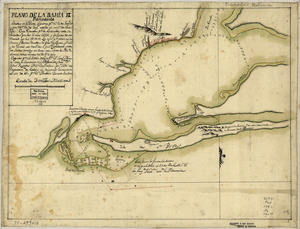
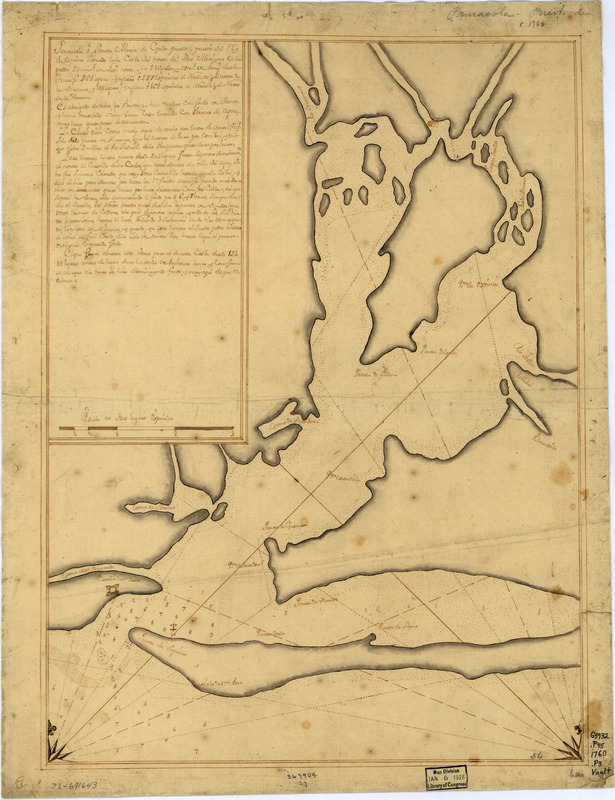
Pansacola o Santta María de Galbe, puerto y presidio del Ry. de España situado en la costa del nortte del Seno Mexicano, los 30 grados 25 mins. de lattd. nortte y los 286 grados y 37 ms. de longd. desde Tenerife 265 leguas inglesas o 227 españolas al nordestte 1/4 al nortte de la Veracruz i 185 leguas inglesas o 162 españolas al nordeste 1/4 al nortte de la Havana
This map is also available in American Revolutionary Geographies Online (ARGO), a collections portal especially built for material relating to the American Revolutionary War Era. Visit ARGO to learn more about this item and explore the historical geography of North America in the late eighteenth century.
Item Information
- Title:
- Pansacola o Santta María de Galbe, puerto y presidio del Ry. de España situado en la costa del nortte del Seno Mexicano, los 30 grados 25 mins. de lattd. nortte y los 286 grados y 37 ms. de longd. desde Tenerife 265 leguas inglesas o 227 españolas al nordestte 1/4 al nortte de la Veracruz i 185 leguas inglesas o 162 españolas al nordeste 1/4 al nortte de la Havana
- Date:
-
[ca. 1760]
- Format:
-
Maps/Atlases
Manuscripts
- Location:
- Library of Congress Geography and Map Division
- Collection (local):
-
Library of Congress Collection
- Subjects:
-
Pensacola Bay (Fla.)--Maps, Manuscript--Early works to 1800
Coasts--Florida--Pensacola Bay--Maps--Early works to 1800
Manuscript maps--Early works to 1800
- Places:
-
Pensacola Bay
- Extent:
- 1 manuscript map : hand color; 45 x 34 cm.
- Terms of Use:
-
No known copyright restrictions.
This work is licensed for use under a Creative Commons Attribution Non-Commercial Share Alike License (CC BY-NC-SA).

- Scale:
-
Scale ca. 1:165,000
- Language:
-
English
- Catalog Record:
-
https://lccn.loc.gov/73691643
- Notes:
-
Watermarks: I. Honig; and, fleur-de-lis.
Mounted on cloth backing.
Manuscript, black and brown inks.
Prime meridian: Tenerife.
Soundings shown in fathoms.
Includes descriptive text.
Printed label describing the map mounted on verso.
Maggs number annotated in pencil in lower right corner: 56.
Order number annotated in pencil in lower margin: 367904/27.
- Notes (citation):
-
LC Maps of North America, 1750-1789, 1653
LC Luso-Hispanic World, 890
- Identifier:
-
ar165300