Plan of burnt district, by fire of Nov. 9th and 10th 1872 : showing street improvements as adopted by Board of Street Commissioners and City Council
Item Information
- Title:
- Plan of burnt district, by fire of Nov. 9th and 10th 1872 : showing street improvements as adopted by Board of Street Commissioners and City Council
- Description:
-
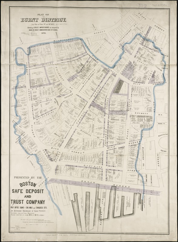
The fire destroyed many businesses in the district including Boston's publishing houses. However, the citizens' spirit and civic pride were revealed, as they quickly rebuilt and implemented reforms in fire and building codes. This 1873 map outlines the burned district, and includes plans for improving streets within that vicinity. Realizing that poorly planned and overcrowded lanes had allowed the fire to spread so easily, the City widened seventeen streets and extended four in the area. Land was cleared to create Post Office Square, new firefighting infrastructure was constructed, and a new downtown rose out of the ashes.
- Creator:
- Davis, Thomas W., surveyor
- Name on Item:
-
Thos. W. Davis, city surveyor.
- Date:
-
1873
- Format:
-
Maps/Atlases
- Location:
-
Boston Public Library
Norman B. Leventhal Map & Education Center - Collection (local):
-
Norman B. Leventhal Map & Education Center Collection
- Subjects:
-
Great Fire, Boston, Mass., 1872--Maps
Boston (Mass.)--Maps
- Places:
-
MassachusettsSuffolk (county)Boston
- Extent:
- 1 map : col. ; 73 x 52 cm.
- Terms of Use:
-
No known copyright restrictions.
No known restrictions on use.
- Publisher:
-
Boston :
[s.n.]
- Scale:
-
Scale 1:600. 1 inch to 50 feet.
- Language:
-
English
- Notes:
-
Oriented with north toward the upper right.
"Presented by the Boston Safe Deposit and Trust Company ..."
- Notes (exhibitions):
-
Exhibited: "Boston in the Gilded Age: Mapping Public Places" organized by the Norman B. Leventhal Map Center at the Boston Public Library, 2012-2013.
- Identifier:
-
06_01_004247
- Call #:
-
G3764.B6E29 1873 .B67x
- Barcode:
-
39999059005288


