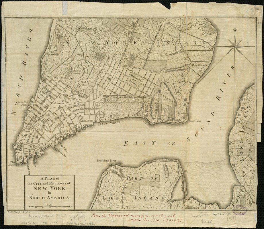
A plan of the city and environs of New York in North America
This map is also available in American Revolutionary Geographies Online (ARGO), a collections portal especially built for material relating to the American Revolutionary War Era. Visit ARGO to learn more about this item and explore the historical geography of North America in the late eighteenth century.
Item Information
- Title:
- A plan of the city and environs of New York in North America
- Date:
-
[1776]
- Format:
-
Maps/Atlases
- Location:
-
Boston Public Library
Norman B. Leventhal Map & Education Center - Collection (local):
-
Norman B. Leventhal Map & Education Center Collection
- Subjects:
-
Land use, Rural--New York (State)--New York--Maps--Early works to 1800
New York (N.Y.)--Maps--Early works to 1800
- Places:
-
New YorkNew York
- Extent:
- 1 map ; 28 x 37 cm.
- Terms of Use:
-
No known copyright restrictions.
No known restrictions on use.
- Publisher:
-
London :
s.n.
- Scale:
-
Scale [ca. 1:12,200].
- Language:
-
English
- Notes:
-
General street map showing selected letter-keyed buildings in built-up area and field lines with generalized land use in rural areas.
Relief shown by hachures.
Also shows "Road to Kings Bridge where the Rebels mean to make a stand" and "Road to Kepps Bay where the Kings troops landed."
Also covers rural part of Manhattan Island up to present-day 14th Street and small parts of Long Island.
Removed from: The Universal Magazine of Knowledge and Pleasure, London, Nov. 1776, v. 59.
Watermark: Oval cartouche surmounted by crown with capital letter W at right.
- Notes (date):
-
This date is inferred.
- Identifier:
-
06_01_006307
- Call #:
-
G3804.N4 1776 .P53
- Barcode:
-
39999059022630
- LCCN:
-
2002623929

![A plan of the city of New-York & its environs to Greenwich, on the North or Hudsons River, and to Crown Point, on the East or Sound River, shewing the several streets, publick buildings, docks, fort & battery, with the true form & course of the commanding grounds, with and without the town : survey'd in the winter, 1775 [i.e. 1766]](https://bpldcassets.blob.core.windows.net/derivatives/images/commonwealth:6t053q479/image_thumbnail_300.jpg)
