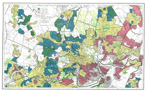
Residential security map of Providence, R.I.
Item Information
- Title:
- Residential security map of Providence, R.I.
- Title (alt.):
-
Map of the city of Providence, Rhode Island
- Description:
-
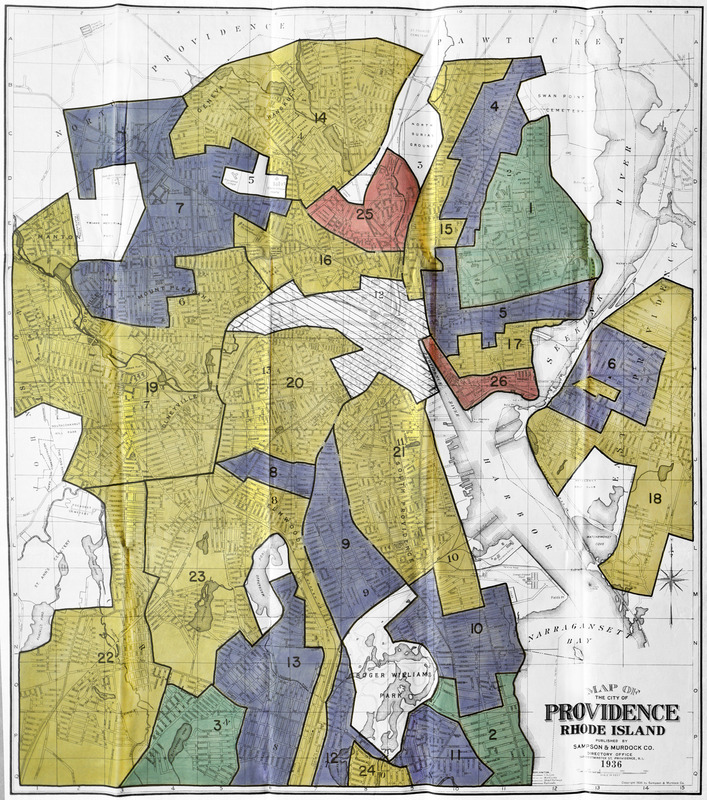
Residential security map assigning grades of "mortgage security" that were used to determine who should receive loans and which areas were safe investments.
- Cartographer:
- Home Owners' Loan Corporation
- Cartographer:
- Sampson, Murdock & Co.
- Date:
-
[1936–1939]
- Format:
-
Maps/Atlases
- Location:
- Mapping Inequality
- Collection (local):
-
Mapping Inequality Collection
- Subjects:
-
Discrimination in housing--Rhode Island--Providence--Maps
Discrimination in mortgage loans--Rhode Island--Providence--Maps
Providence (R.I)--Maps
- Places:
-
Providence (county)Providence
- Extent:
- 1 map : color
- Terms of Use:
-
No known copyright restrictions.
This work is licensed for use under a Creative Commons Attribution Non-Commercial Share Alike License (CC BY-NC-SA).

- Publisher:
-
[Washington, D.C.] :
[Home Owners' Loan Corporation]
- Language:
-
English
- Catalog Record:
-
Interactive Map
- Notes:
-
Image from "Mapping Inequality" https://dsl.richmond.edu/panorama/redlining.
- Notes (date):
-
This date is inferred.
- Identifier:
-
RI_Providence