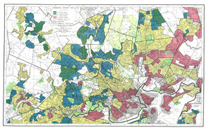
Residential security map of Boston, Mass.

Item Information
- Title:
- Residential security map of Boston, Mass.
- Title (alt.):
-
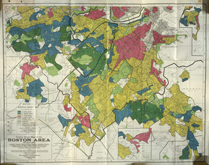
Cram's street map of the Boston area : 260 square miles including Arlington, Belmont, Boston, Brookline, Cambridge, Chelsea, Dedham, Everett, Lexington, Malden, Medford, Melrose, Milton, Needham, Newton, Quincy, Revere, Somerville, Waltham, Watertown, Winchester and Winthrop
- Description:
-
Residential security map assigning grades of "mortgage security" that were used to determine who should receive loans and which areas were safe investments.
- Cartographer:
- Home Owners' Loan Corporation
- Cartographer:
- George F. Cram Company
- Name on Item:
-
prepared by Division of Research and Statistics with the co-operation of the Appraisal Department, Home Owners' Loan Corporation
- Date:
-
1938
- Format:
-
Maps/Atlases
- Location:
- Mapping Inequality
- Collection (local):
-
Mapping Inequality Collection
- Subjects:
-
Discrimination in housing--Massachusetts--Boston Metropolitan Area--Maps
Discrimination in mortgage loans--Massachusetts--Boston Metropolitan--Maps
Boston Metropolitan Area (Mass.)--Maps
- Places:
-
Suffolk (county)Boston
Middlesex (county)Arlington
Middlesex (county)Belmont
Norfolk (county)Brookline
Middlesex (county)Cambridge
Suffolk (county)Chelsea
Norfolk (county)Dedham
Middlesex (county)Everett
Middlesex (county)Lexington
Middlesex (county)Malden
Middlesex (county)Medford
Middlesex (county)Melrose
Norfolk (county)Milton
Norfolk (county)Needham
Middlesex (county)Newton
Norfolk (county)Quincy
Suffolk (county)Revere
Middlesex (county)Somerville
Middlesex (county)Waltham
Middlesex (county)Watertown
Middlesex (county)Winchester
Suffolk (county)Winthrop
- Extent:
- 1 map on 2 sheets : color
- Terms of Use:
-
No known copyright restrictions.
This work is licensed for use under a Creative Commons Attribution Non-Commercial Share Alike License (CC BY-NC-SA).

- Publisher:
-
[Washington, D.C.] :
Home Owners' Loan Corporation
- Language:
-
English
- Table of Contents:
-
Section 1
Section 2
- Catalog Record:
-
Interactive Map
- Notes:
-
Image from "Mapping Inequality" https://dsl.richmond.edu/panorama/redlining.
Also shows land use.
Insets: Winthrop extension -- Quincy, Boston.
- Identifier:
-
MA_Boston1


![Boston personal income ; Boston personal income [and] residential population density](https://bpldcassets.blob.core.windows.net/derivatives/images/commonwealth:fn107c409/image_thumbnail_300.jpg)
