Introduction
Histories of map-making generally emphasize the role of men; however, since the advent of the printed map, women have worked as colorists, engravers, shop owners, publishers, and, most importantly, as map-makers themselves. Women are active in all aspects of cartography today and are leaders in the world of Geographic Information Systems (GIS) and digital mapping. In this exhibition of forty maps, globes, atlases and works of art from the 17th century to the present, visitors will encounter works by female map creators, designers and educators, learn about the various cartographic skills employed by women over the centuries, and observe the transition of women in cartography from marginalized to celebrated.
1. Earliest Roles

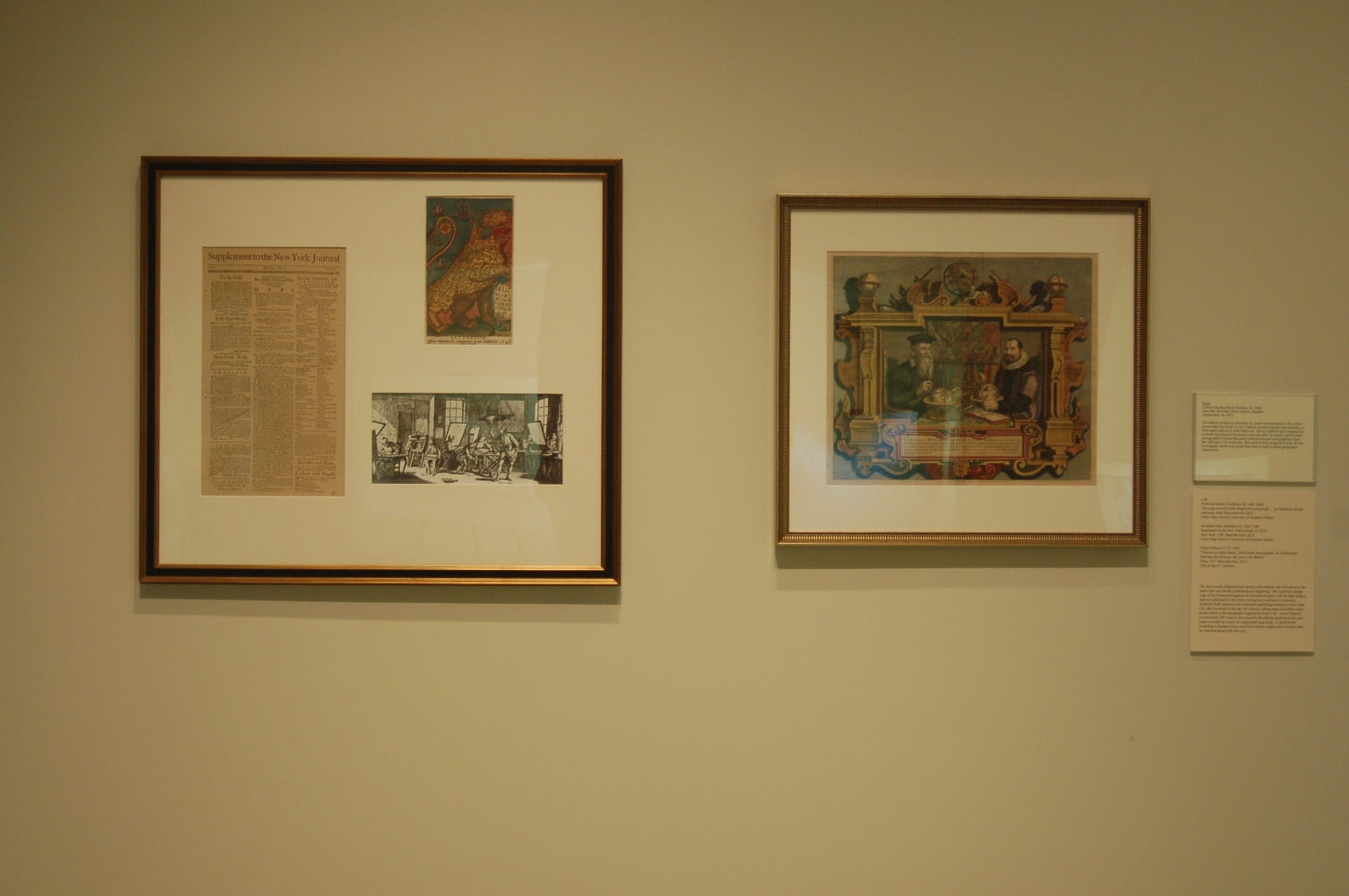
Colette van den Keere Hondius (d. 1629)
Gerardus Mercator Natus Iodocus Hondius …
Amsterdam, ca. 1613.
The widow of Jodocus Hondius, Sr. took over his business for a short period after his death in 1612, before transferring the responsibility to their sons Jodocus Jr. and Henricus. She is credited with creating this portrait honoring her husband, one year after his death, and Flemish cartographer Gerard Mercator, both prominent cartographers from the 16th and 17th centuries. Mercator is still recognized today for his rectangular world map projection that is used in many geography classrooms.
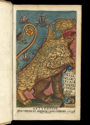
Weduwe Joannis Cnobbaert (fl. 1640-1649)
Title page from De Bello Belgico Decas Secanda … by Famianus Strada
Antwerp, 1648. Reproduction, 2015.
Osher Map Library, University of Southern Maine.
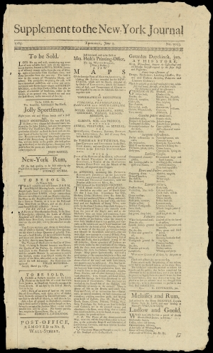
Elizabeth Holt, Publisher (fl. 1784-1788)
Supplement to the New-York Journal, no. 2013
New York, 1785. Reproduction, 2015.
Osher Map Library, University of Southern Maine.
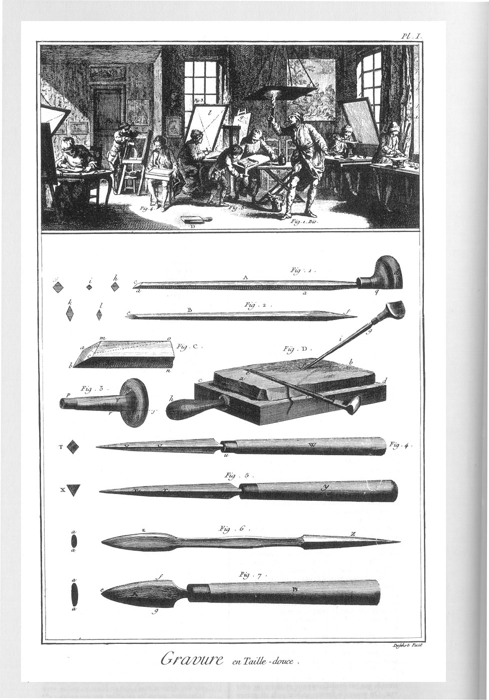
Denis Diderot (1713-1784)
“Gravure en taille-douce,” detail from Encyclopédie, ou Dictionnaire Raisonné des Sciences, des Arts et des Métiers
Paris, 1767. Reproduction, 2015.
Gift of Alice C. Hudson.
The three works displayed here speak to the earliest roles of women in the map trade, specifically publishing and engraving. The small lion-design map of the Netherlands appears in Famiano Strada’s 1648 De Bello Belgico, and was published by the widow of Joannis Cnobbaert in Antwerp. Elizabeth Holt continued her husband’s publishing business in New York City after his death in the late 18th century, selling maps and other wares, as described in this newspaper supplement from 1785. Denis Diderot’s revolutionary 18th-century encyclopedia describing mechanical arts and trades includes an article on copperplate engraving. A detail of the workshop is displayed here, and three women employed in various tasks are depicted along with the men.
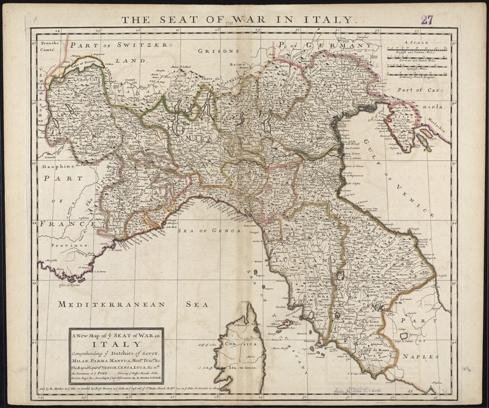
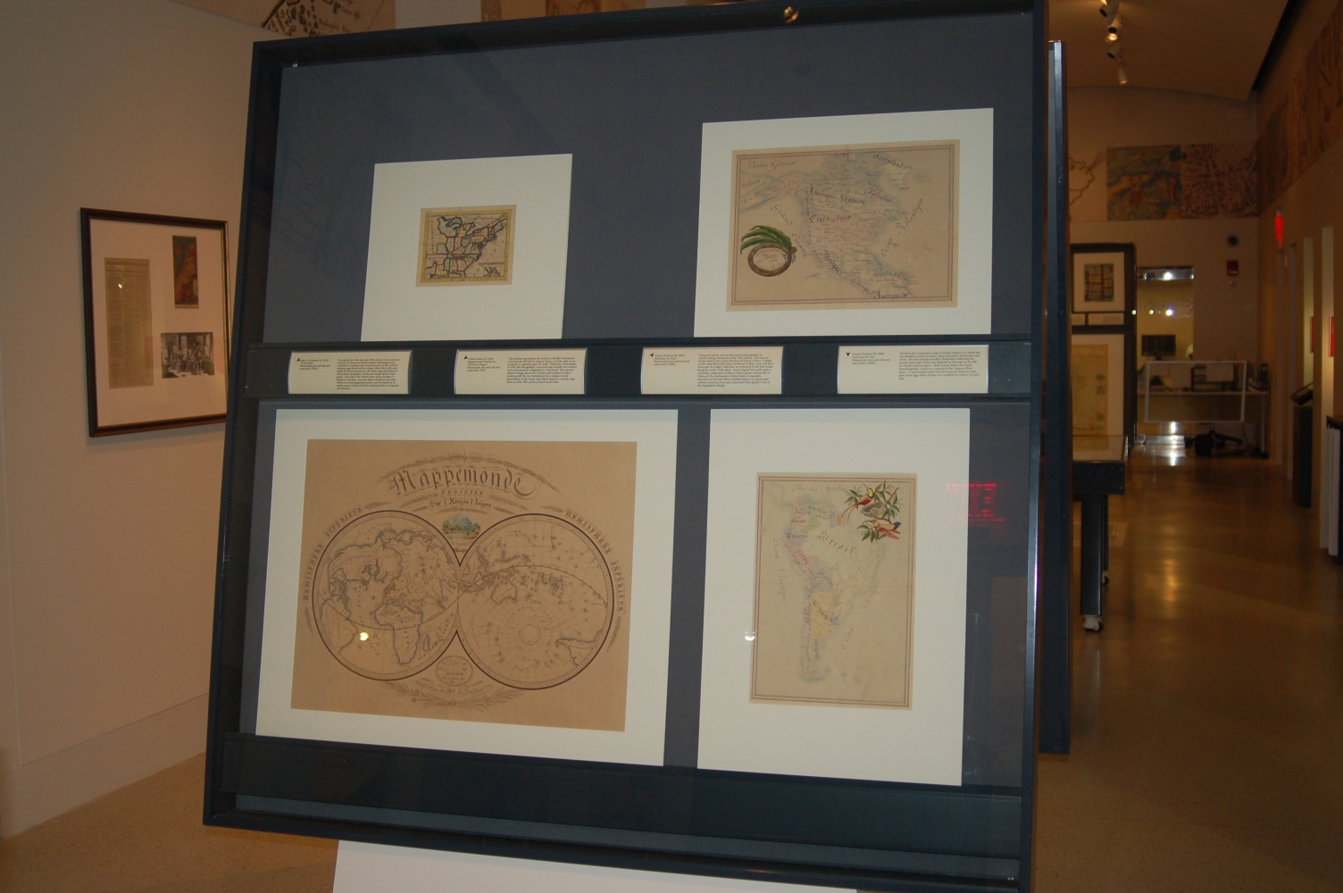
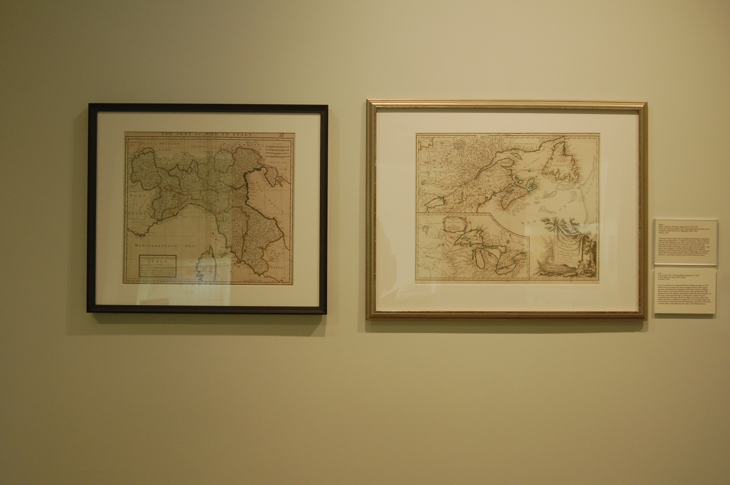
Ann Lea (fl. 1701-1730) and Robert Morden (d. 1703)
A New Map of ye Seat of War in Italy
[London, 1701]
Ann Lea took over her deceased husband Philip’s business in 1701, and for the next twenty-five years managed the firm with various partners, including Robert Morden, Christopher Browne, William Berry and her son-in-law Richard Glynne. She published the map displayed here with Morden and Browne while she was in business “at the sign of Atlas and Hercules” in Cheapside, London. Part of a composite atlas, this map reflects the region of northern Italy with various duchies, or dukedoms, fought over and exchanged under the rule of France, Switzerland and the Habsburgs, until Italy evolved into a unified nation extending from the Alps to the Mediterranean.
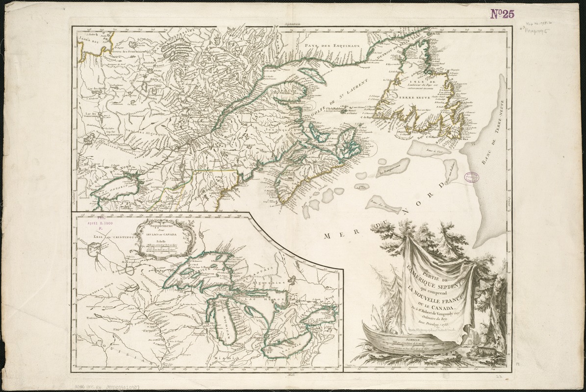
Marie Catherine Haussard, engraver (fl. 1752-1758)
Partie de l’Amérique septent? qui Comprend la Nouvelle France ou le Canada by Gilles Robert de Vaugondy (1688-1766)
[Paris], 1755
This hand-colored map of the Canadian north features a cartouche engraved and signed by C. (Catherine) Haussard. Marie Catherine and her sister Elizabeth were 18th-century Parisian engravers who specialized in the creation of cartouches – the decorative and informative label identifying a map, its author and the subject. The sisters were daughters of noted French engraver Jean-Baptiste Haussard, who trained them in the art of engraving. The cartouche shown here incorporates popular 18th-century symbols of North America – pine trees, a beaver, and a Native American canoe.
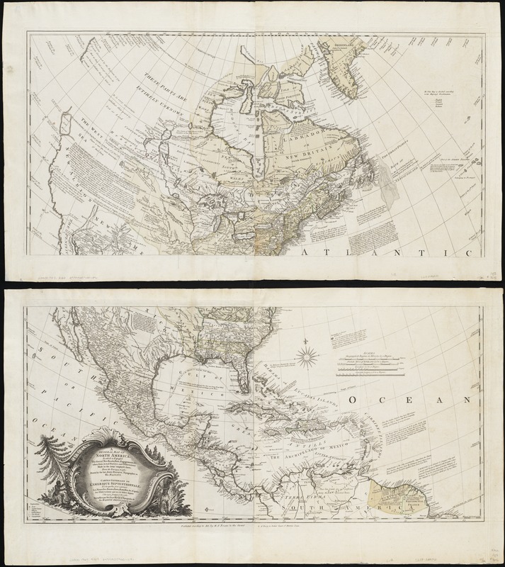
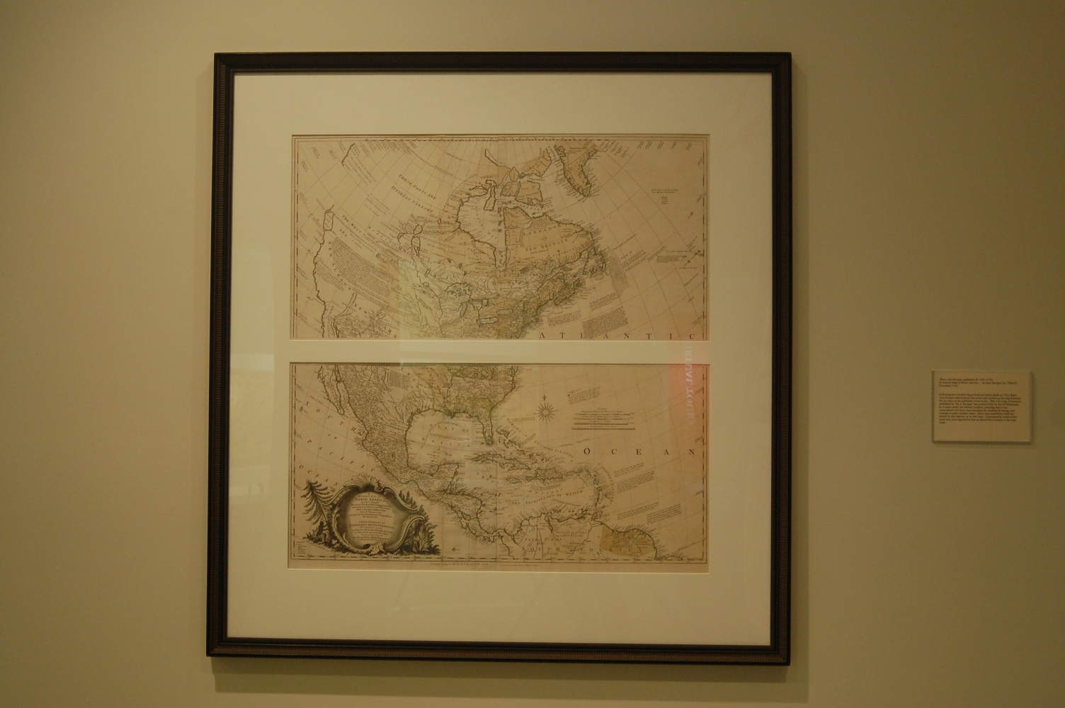
Mary Ann Rocque, publisher (fl. 1762-1770)
A General Map of North America … by John Rocque (ca. 1704-62)
[London], 1762.
Following her London-based husband John’s death in 1762, Mary Ann Rocque administered his estate and carried on his map business for six years as the publisher of his works. This 1761 map of America published by “M.A. Rocque” was protected by an Act of Parliament, as it states under the bottom neatline, meaning that it was copyrighted and there were penalties for stealing the design and reusing it under another name. Mary Ann sometimes used her initials in the imprint, as on this map. Consequently, much of her work was unrecognized as that produced by a woman in the map trade.
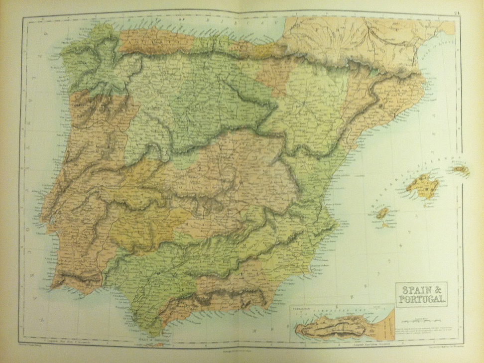
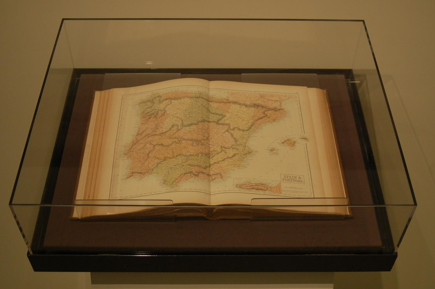
Selina Hall, engraver (fl. 1831-d. 1853)
“Spain & Portugal,” in Black’s General Atlas of the World by Adam and Charles Black
Edinburgh, 1860.
Selina Hall continued publishing her husband Sidney’s maps, sometimes with revisions, after he died in 1831. The map of the Iberian peninsula displayed here from 1860 was published by Selina under her initial “S.,” implying “Sidney,” most likely to capitalize upon her deceased husband’s reputation as a major map publisher of the early 19th century. Her maps, signed “S. Hall,” appear many times in Adam and Charles Black’s General Atlas from 1841 on. Various library records and bibliographical studies over the decades erroneously credited Sidney with the work long after his death, when “S.” for Selina appears in the credit line.
2. Geographic Education
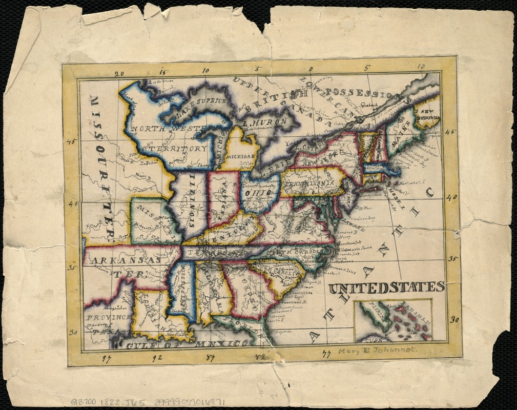
Mary E. Johonnot (b. 1812)
United States
Manuscript; pen-and-ink and watercolor; [1828]
During the late 18th and early 19th century, it was common practice for American female students attending private academies to prepare maps of various parts of the world by copying maps from books or atlases. Most often, girls were taught by female instructors, who drew maps themselves to demonstrate geographic, artistic and design skills to their pupils. This map of the United States, drawn by Mary E. Johonnot of Boston, was most likely compiled in the 1820s as a school geography project, and was based on an earlier map as evidenced by the missing borders of Arkansas and Missouri.
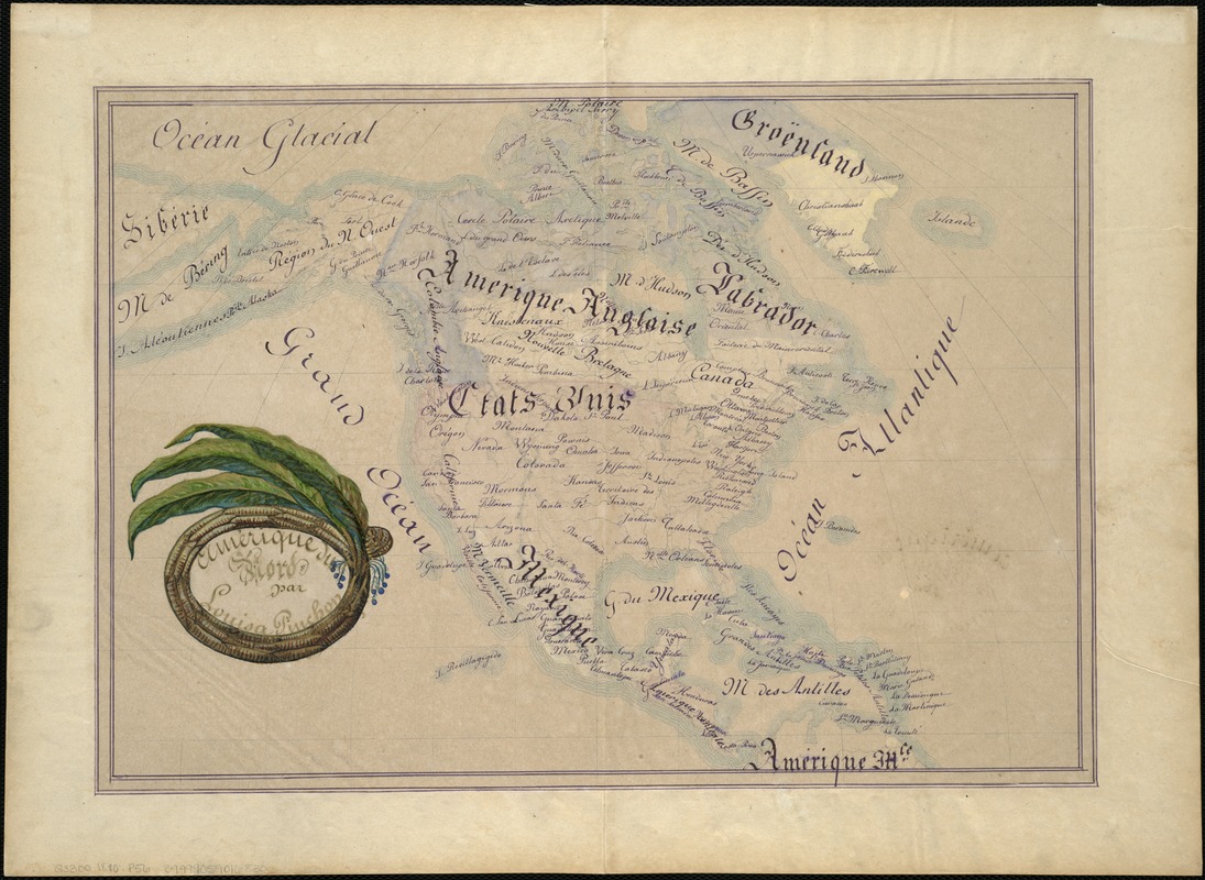
Louisa Pinchon (fl. 1880)
Amérique du Nord
Manuscript; pen-and-ink and watercolor; [1880]
Young European women also practiced geography in school-settings during the early 19th-century. This map of North America by Louisa Pinchon of Elbeuf, France, a village on the Seine River fifty miles northwest of Paris, may well have been part of a larger collection, as evidenced by the fold marks along the center of the sheet. Louisa signed her work under a cartouche comprised of tobacco leaves, grown extensively in Cuba and the southeastern United States. Geographic education at the time often included lessons on natural and cultural resources of an area, and most likely played a role in the mapmaker’s design.
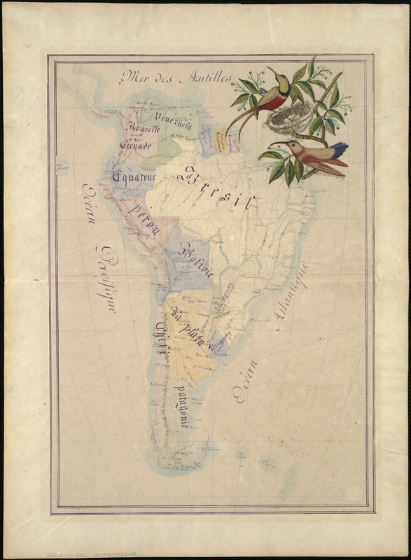
Louisa Pinchon (fl. 1880)
Amérique du Sud
Manuscript; pen-and-ink and watercolor; [1880]
Pinchon also composed a map of South America, in which she has detailed country borders, cities and towns, mountains and rivers. She has included another illustration reflecting the natural landscape of the area depicted in the map, as she did for North America above. Here Louisa draws two Topaz hummingbirds, which are common in the Amazon River basin. A red-breasted male with two long tail feathers looks after three eggs with a female bird rendered in yellow, red and blue.
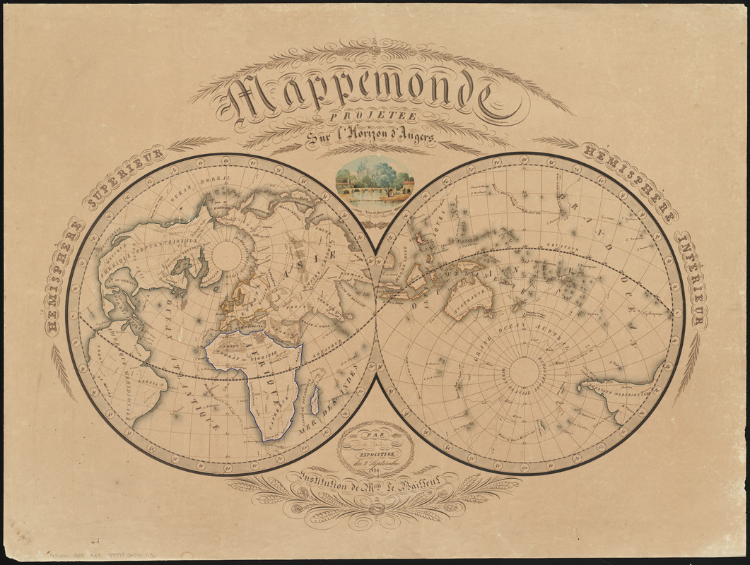
Céleste Babin (fl. 1839)
Mappemonde Projetée sur l’Horizon d’Angers
Manuscript; pen-and-ink and watercolor; 1839.
This student map depicts the world in a double-hemisphere, centering the left half on Angers, France, and the right on its antipode, or opposite point on earth. Drawn by a French girl in 1839, this thoughtfully conceived map includes two colored views and extensive calligraphy in a fine hand. The unusual elliptical design places the northern and southern borders meshing with the two hemispheres for a unique overall presentation of the world, most likely based on a similar map from an early 19th-century French world atlas.
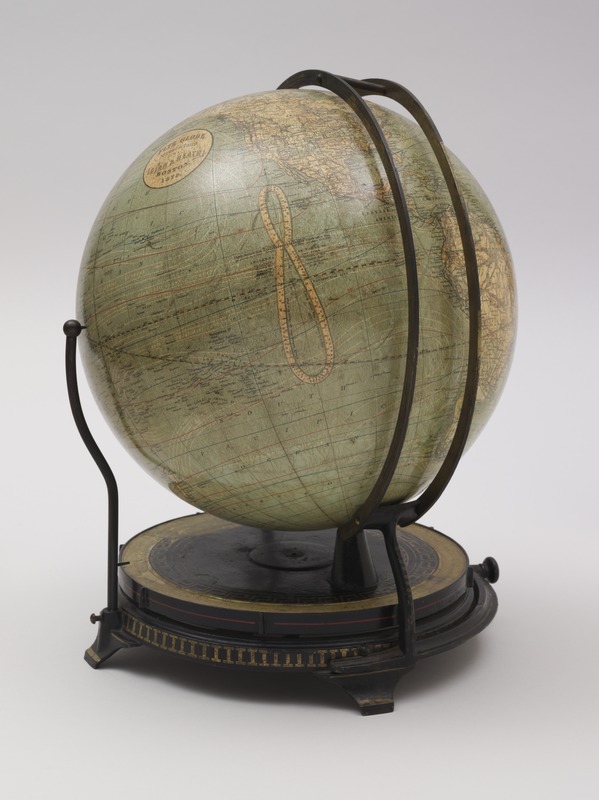
Ellen Eliza Fitz (b. 1836)
Fitz Globe
Boston, [1879]
This classroom globe was published in Boston by the textbook firm of Ginn and Heath. The mounting system, with two vertical rings showing the changing daylight, twilight and nighttime hours any place on the Earth, was patented in 1876 by Ellen Fitz, a former governess, and was displayed later that year at the Philadelphia Centennial Exhibition. Fitz was the first woman involved in the design and manufacturing of globes, and her unique contribution to this educational tool – the globe’s mounting – was intended to help students understand the effects of the Earth’s daily rotation on its axis and yearly revolution around the sun.
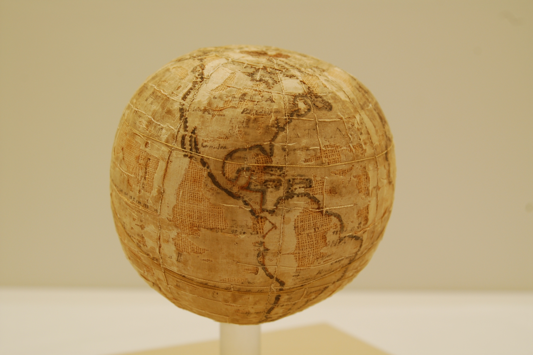
Anonymous Female Student
[Terrestrial Globe]
Westtown, Penn., ca. 1810-1843.
Embroidered globes, such as the one displayed here, were unique to the Westtown School – a Quaker boarding school in West Chester, Pennsylvania. Made at this site by the female students between 1804 and 1844, these items were intended to teach mathematical geography, astronomy, the use of globes and needlework simultaneously. Young girls learned sewing skills by first making samplers, while older girls produced items such as pocket books, pin cushions, and globes. The item’s deterioration is surprisingly helpful, in that it reveals the process by which the globe was created, with silk thread embroidered over linen, mounted over wool, and inked map boundaries and place names.
How the globes were made: Each Westtown globe is between 5 to 6 inches in diameter, and is made of silk over a stitched canvas form, which is stuffed with raw wool. The form was made first, and then the silk gores were stitched together. A seam was left open in the silk to insert the form. The outlines and graticule (latitude and longitude lines) were made with simple stitches, as were parallels and meridians. The lettering was then inked onto the silk. Only a few of the 30 known globes show the maker’s name. The globes were designed to be used, and many were mounted on wooden stands – the globe displayed here is an example of that variety. Westtown teacher Samuel Gummere’s Definitions and Elementary Observations in Astronomy was used as an instructional reference when constructing the globes.
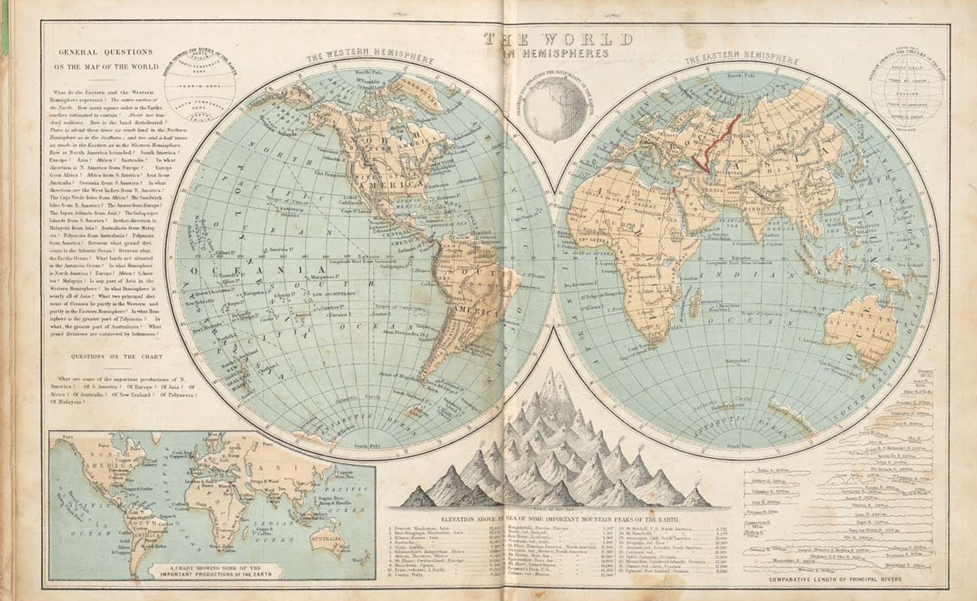
Sophia Sara Cornell (1815-1873)
“The World in Hemispheres” in Cornell’s Intermediate Geography
New York, 1871.
Image from Osher Map Library, University of Southern Maine.
Geography books which contained maps and illustrations were useful and popular visual aids for children studying the subject in the 19th-century. Sophia Cornell’s many atlases “were seen everywhere in the little red schoolhouses” across the nation, according to the Appleton firm. The simple double-hemisphere world map displayed here appears in Cornell’s Intermediate Geography, a text intended for middle-school children. The questions at left are teaching tools, along with informative insets of world economic production, comparative mountain elevations, smoky keys to volcanoes, and comparative river lengths.
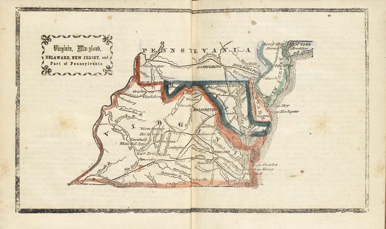
Marinda Branson Moore (1829-1864)
“Virginia, Maryland, Delaware …,” in Primary Geography: Arranged as a Reading Book for Common Schools …
Raleigh, North Carolina, 1864.
Image from Osher Map Library, University of Southern Maine.
Marinda Branson Moore’s Geographical Reader – the first geography textbook published in the Confederacy – was intended to be a simple course of study for young Southern children during the Civil War. The book contains maps mainly of the southern states, and has comments referring to the United States as “tumbling into ruins, with the calamity brought about by Yankee injustice and avarice.” Displayed here is a map of Virginia and environs from the second edition of Moore’s geography entitled Primary Geography. At the time this book was published, West Virginia had not yet separated from Virginia, as illustrated in this map.
3. Travel and Tourism
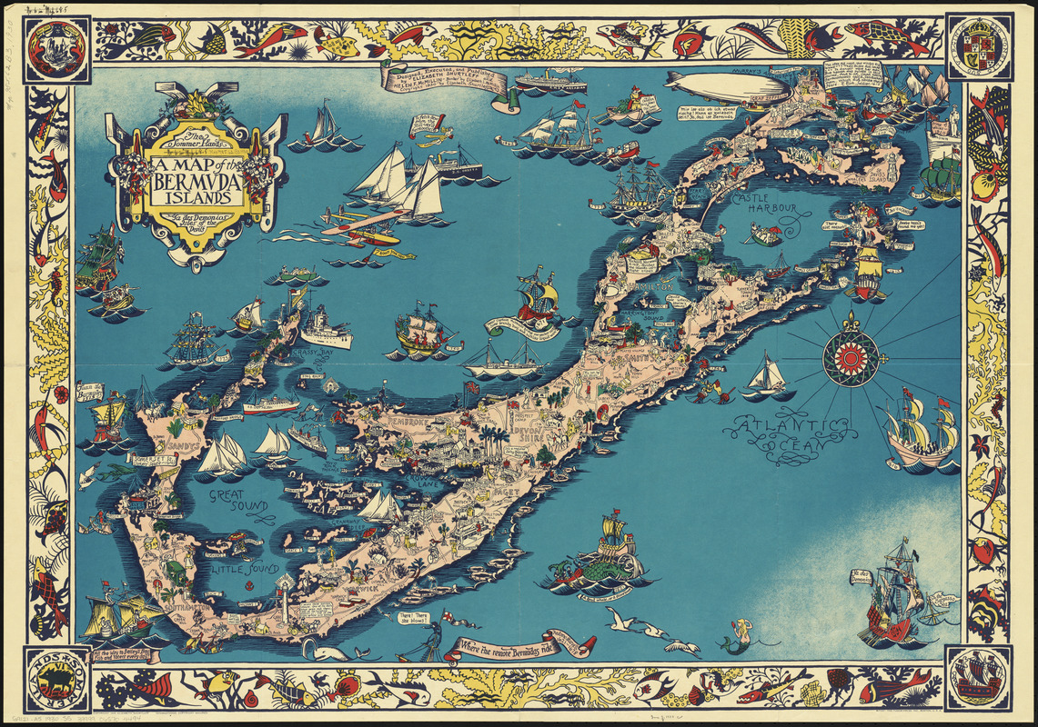
Elizabeth Shurtleff (b. 1890) and Helen F. McMillin (fl. 1930)
A Map of the Bermuda Islands …
New York, 1930.
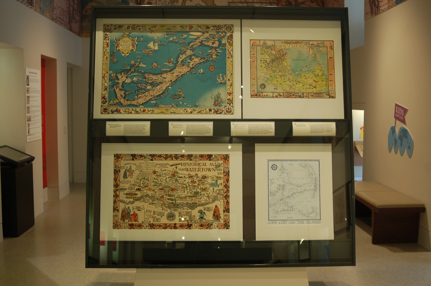
Women were very active in the production of pictorial maps in the early 20th-century. These whimsical maps frequently focused on travel and tourism. Bordered by a ribbon of ocean creatures, this 1930 map of Bermuda illustrates various methods of transportation from horse-drawn carriages to pirate ships and airplanes. On shore, tourism reigns with beaches, golf courses, tennis courts, shooting ranges and historic forts. Designed by Elizabeth Shurtleff and Helen McMillin, who studied at the Boston Museum School of Fine Arts and Wellesley College respectively, this map encourages visits to the island by promoting recreation and history.

Ruth Haviland Sutton (1898-1960)
Nantucket
Nantucket, 1946. Reproduction, 2015.
Gift of Alice C. Hudson.
Nantucket-based artist Ruth Haviland Sutton produced many prints and oil paintings while residing on the island for nearly forty years. Sutton designed this map of her home in 1946, and it was originally lithographed by her teacher, printmaker George Miller. The map highlights natural features such as plant, animal and bird species and documents favorite island locales, including landmarks and hotels, while the marginal vignettes detail Nantucket’s Native American, agricultural, fishing, early industrial and urban history. This colorful and lively map of the “faraway land,” as it was known by native inhabitants, depicts the island as a retreat for wildlife and leisure enthusiasts.
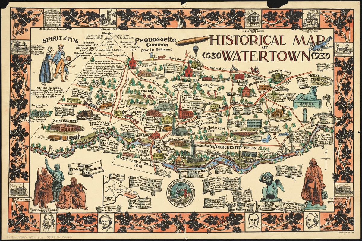
Mary B. Hotz (fl. 1930)
Historical Map of Watertown, 1630-1930
[Watertown, Mass.], 1930.
Mary Hotz designed this map as a high school student in 1930, for a poster contest celebrating the 300th anniversary of Watertown, Massachusetts. Her map of historical Watertown, complete with Native Americans, houses, churches, arsenals, courthouses, taverns, mills, schools and statues was the winning entry. Hotz combined recent and past history in this colorful and detailed map, which she shared with local community clubs, and President Calvin Coolidge, who had family ties to the town. She eventually attended art school in Boston, but never practiced professionally; however, her map appeared for years in official buildings and private residences throughout Watertown.
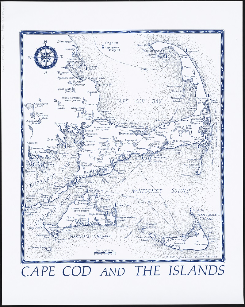
Jane Crosen (fl. 1983-)
Cape Cod and the Islands
Penobscot, Maine, 1999.
Jane Crosen, a Maine-based mapmaker and publisher, began making maps in the early 1980s. Crosen used topographic maps and nautical charts, combined with field-checking to produce her early maps. Since then, she has created a number of maps of Maine’s coastal and lakes regions – places that hold special meaning to her. Each aspect of the maps is designed by hand. This fine level of detail and artistry is evidenced by the line art map of Cape Cod displayed here. Using stippling to enhance shading, Crosen adds depth to her maps while using only one color.
4. Mapmakers
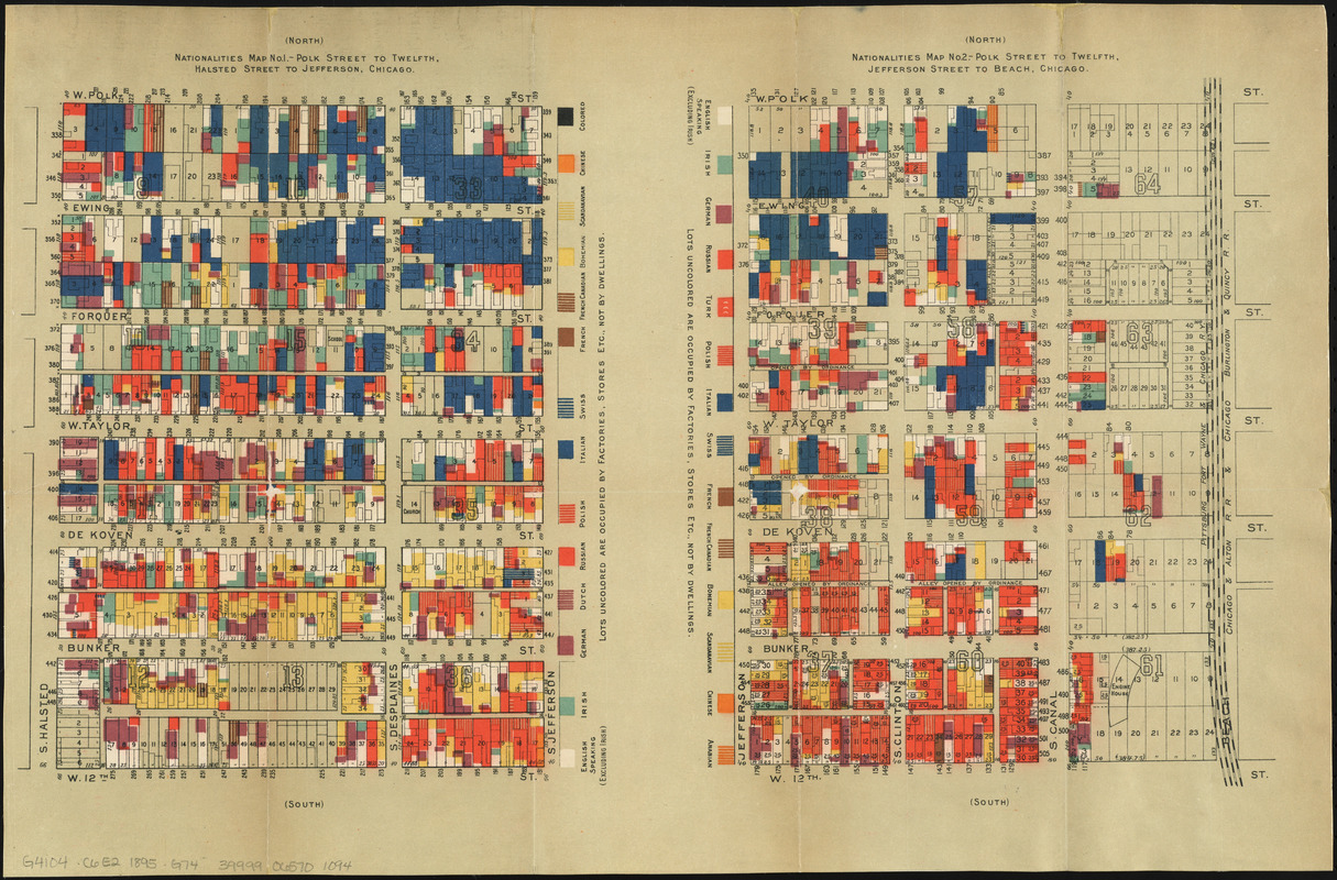
Agnes Sinclair Holbrook (fl. 1867-1897)
“Nationalities Map No. 1,” from Hull-House Maps and Papers …
New York, 1895.
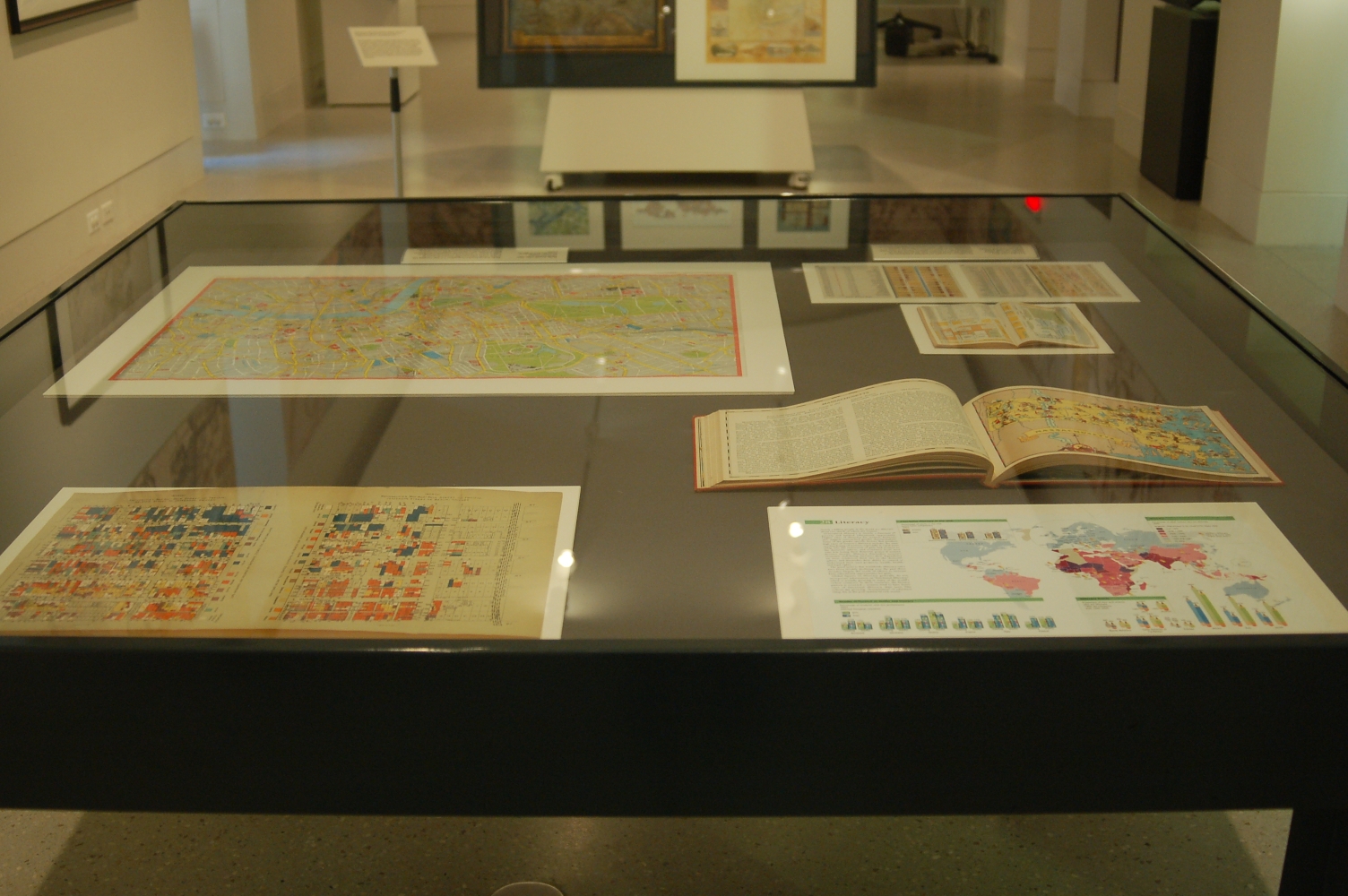
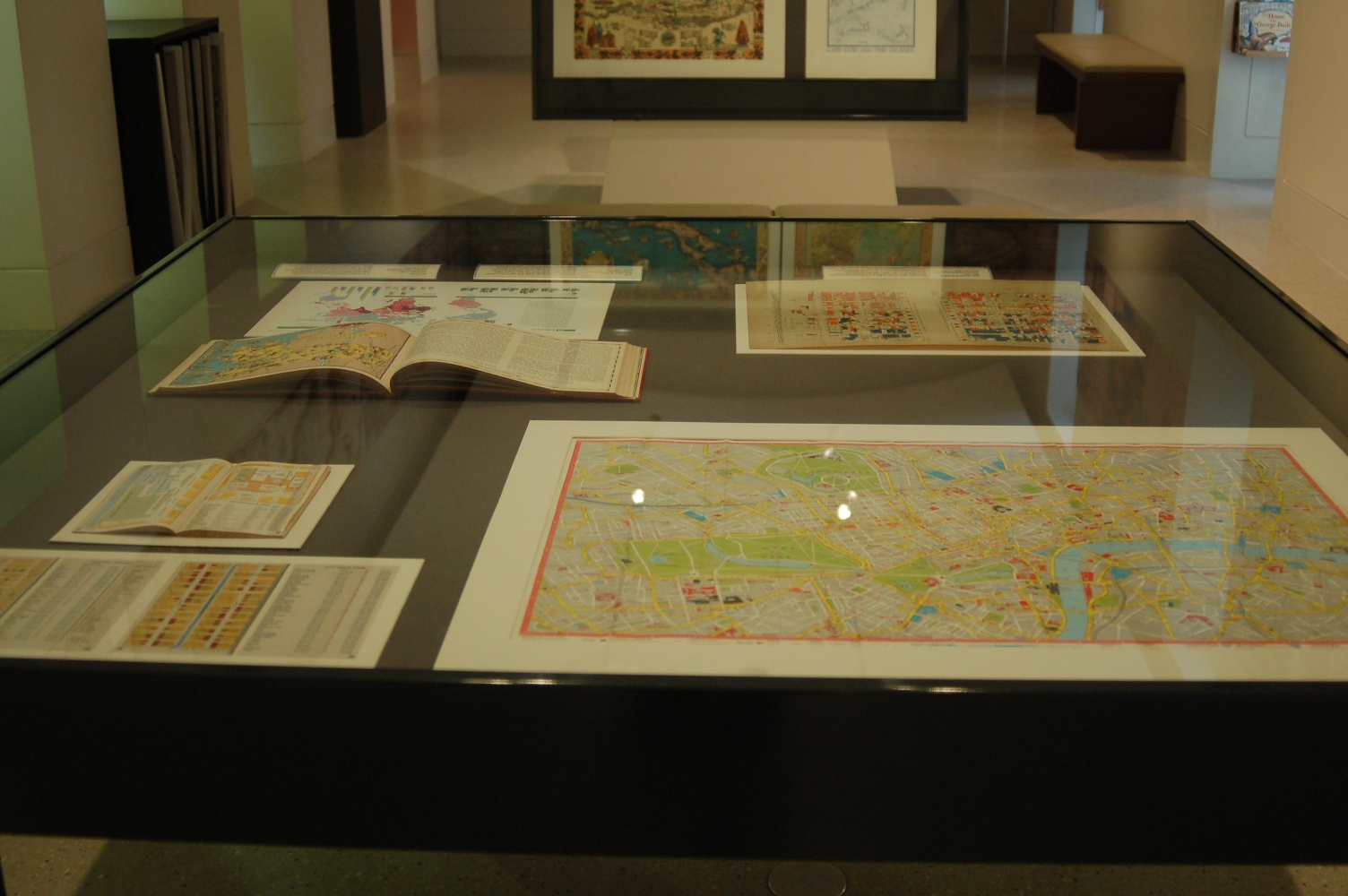
Designed by Agnes Sinclair Holbrook, a Wellesley College graduate and resident of Chicago’s Hull-House, this thematic map of the neighborhood east of the House illustrates the immigrant population living in the area. A female-based social settlement in Chicago’s Near West Side, Hull-House played an important role in social reforms of the late 19th-century, and its residents were responsible for transcribing, interpreting and mapping statistical data for the map displayed here. Part of a set of four, the map is heavily influenced by earlier statistical mapping by Charles Booth’s wage maps of London, first published in 1889. This statistical cartographic presentation foreshadows GIS mapping – using color and statistics to present social facts.
Phyllis Pearsall (1906-1996)
AZ Visitors’ London
Sevenoaks, Kent (England), [1976]
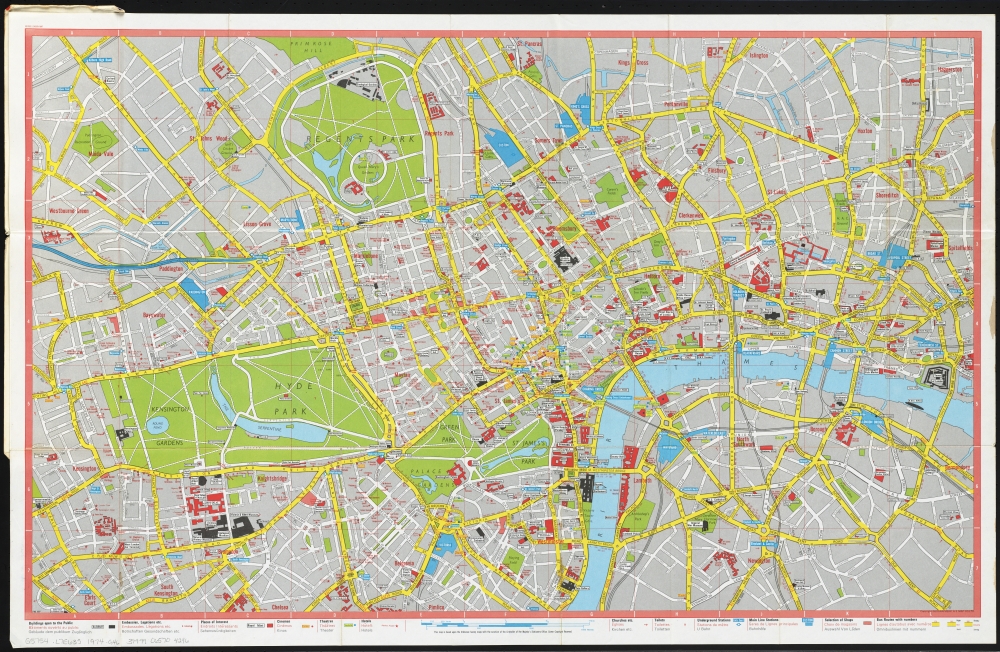
Phyllis Pearsall founded Geographers’ A-Z Map Company in 1936, and for years personally surveyed the streets of London on foot, to research and produce popular guides to public buildings, parks, landmarks, neighborhoods and streets. Pearsall recalls in her youth becoming lost on her way to a party, and this experience prompted the idea of her making maps of the city. Her name, however, does not appear on any of the maps published by the company. Displayed here is a tourist map of London, focused on the Buckingham Palace and Westminster Hall area.
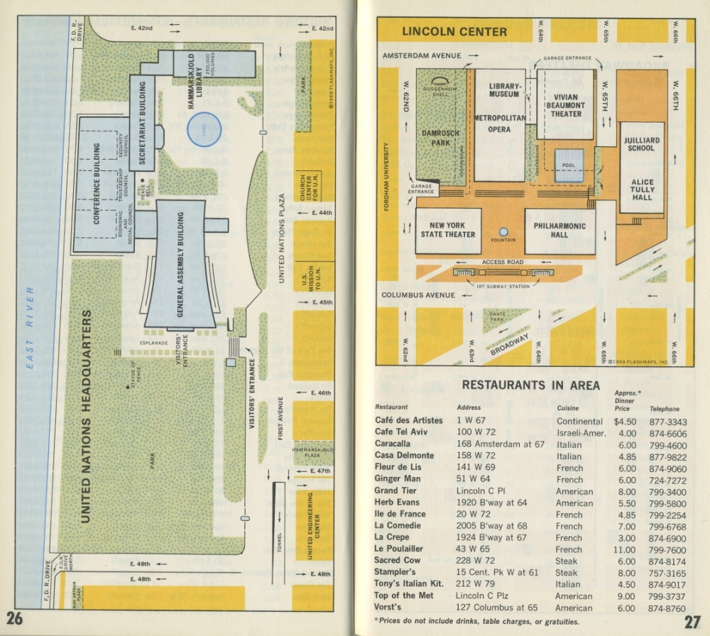
Toy Lasker (1929-2011)
“Lincoln Center,” “Broadway Theaters” and “Fifth Avenue Shops” from New York in Maps: An Instant Guide to Every Place in Town
New York, 1970.
Toy Lasker was the founder and publisher of Flashmaps, Inc., a company that created thematic maps and guidebooks which focused on topics of interest to residents, tourists and the business community. She produced 3 million maps of various major cities and popular tourist destinations before selling the company to Random House in 1987. Lasker conceived and designed the maps displayed here in 1967, partnering with New York Magazine to create this cartographic key to Manhattan art galleries, museums, restaurants, parks, theatres, shops and transportation. These popular maps were used decades ago as smartphones are used today – helping visitors locate their places of interest.
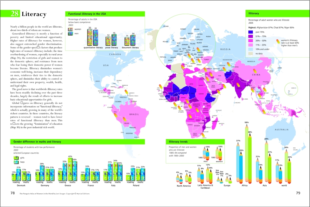
Joni Seager (1956-)
“Literacy,” from The Penguin Atlas of Women in the World
New York, 2009.
Reproduced with permission from The Penguin Atlas of Women in the World by Joni Seager © Myriad Editions | www.myriadeditions.com
In her work as a feminist geographer and professor, Joni Seager has published numerous works on environmental policy, global status of women, and gender and climate change. The world map documenting literacy rates displayed here appears in Seager’s award-winning Atlas of Women in the World, a work in which statistics related to women are cleverly mapped. Here, much of southern Asia and Africa are shown to be high in illiteracy, while Europe and America are much less so. The pencil graphs on the right show the varying percentages of regional illiteracy rates over a ten-year period.
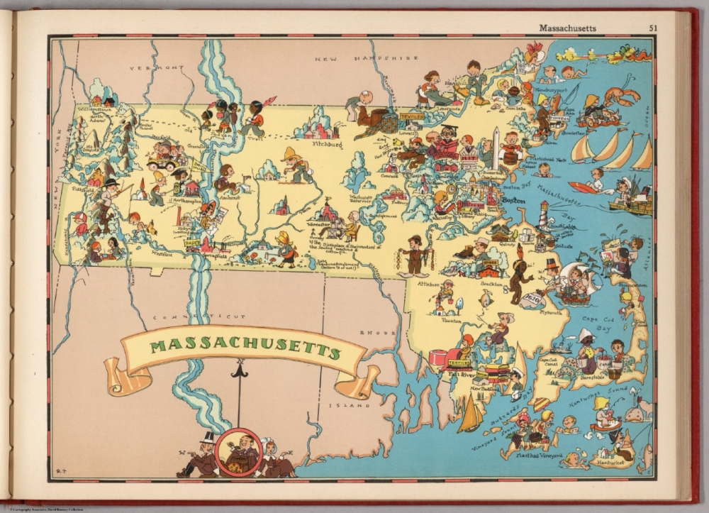
Ruth Taylor (b. 1897)
“Massachusetts,” in Our U.S.A.: A Gay Geography
Boston, 1935.
Partnering with her brother Frank, Ruth Taylor created the fun pictorial maps for each state in this atlas. The pair began working together in the 1920s, with Frank writing text and Ruth providing illustrations. In this map of Massachusetts industries, pastimes and places of interest all are illustrated in Taylor’s whimsical style. Western Massachusetts features several colleges, while industries such as paper and textile mills are seen in the central portion. Along the eastern shoreline the fishing, lobster and crab industries thrive and more universities appear, along with a “famous public library” in Boston.
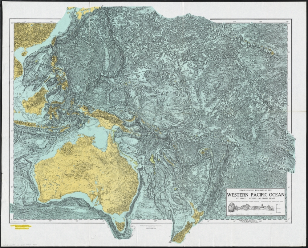
Marie Tharp (1920-2006) and Bruce Heezen (1924-1977)
Physiographic Diagram of the Western Pacific Ocean
Boulder, Colorado, 1971. Reproduction, 2015.
Oceanographic cartographer and geologist Marie Tharp, along with her research partner Bruce Heezen, created the first map of the entire ocean floor. Heezen was credited solely for their work for years, and only later on did Marie gain her rightful place in the cartographic world. Early editions of ocean floor mapping – as the example reproduced here – feature an informal sketch style, while later final editions were sophisticated physical maps with color and shading, applied to reveal the dramatic mid-ocean canyons highlighting the continental divisions of the globe. Numbers on the map indicate depth of the ocean floor and elevations of individual undersea mountains.
5. Maps as Art
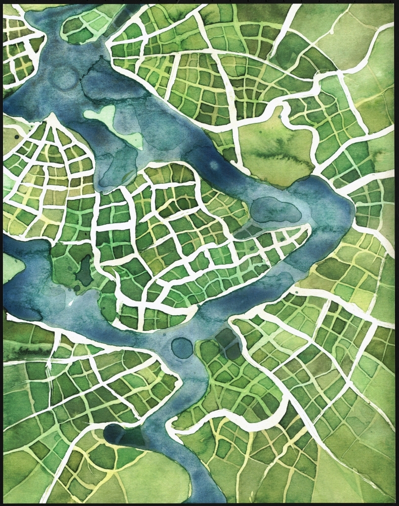
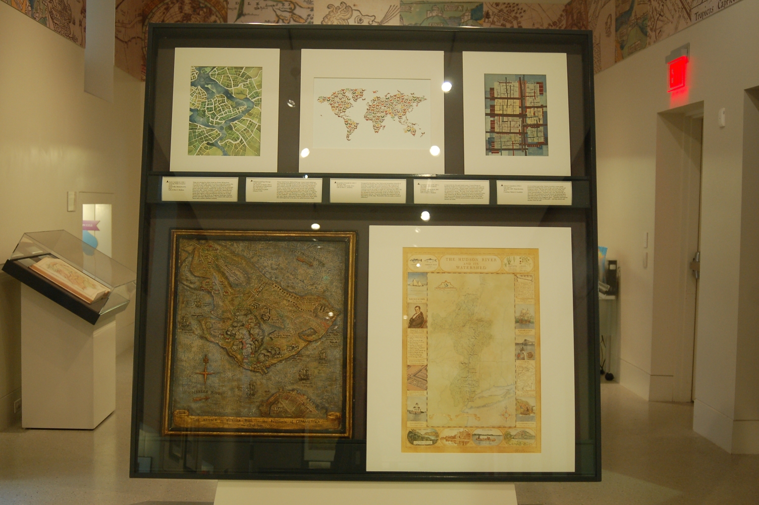
Emily Garfield (fl. 2008-)
Growing Fields (Cityspace #100)
Somerville, Massachusetts, 2012.
Gift of Alice C. Hudson.
Maps are among the oldest visual art forms, dating from pre-history. Although based on science, maps also require the creativity of the cartographer, a fact much appreciated and echoed by modern artists. Displayed in this case are paintings, prints, and quilts which combine the qualities of composition, form and color. Emily Garfield, a Somerville, Massachusetts-based artist, creates maps of imaginary places in a variety of media that explore urban development and the use of maps themselves. Growing Fields, an imaginary landscape of green patches and water, displayed here, is created with watercolor layers and a rubber-resistant medium.
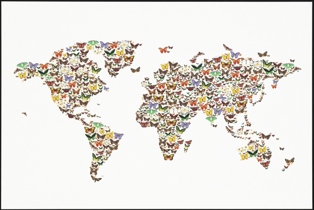
Jacqueline Schmidt (fl. 2007-)
Butterfly Map
Brooklyn, New York, 2014.
Gift of Alice C. Hudson.
Designed by Brooklyn, NY artist Jacqueline Schmidt of Screech Owl Design, this colorful world map composed of butterflies combines the artist’s interests in the natural and fantastic worlds. This creative representation of the winged-creatures across the earth is simply art, and does not reflect the scientific data on butterfly locales across the globe; however, the whimsical subject and design of the art evokes a spirit of playfulness and joy. The artist includes this statement in her description of the map, “Remember that you make a world of difference.”
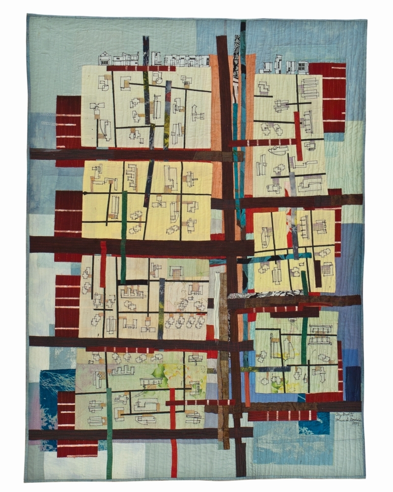
Valerie S. Goodwin (1954-)
City Grid IV
[Florida], 2007. Reproduction, 2015.
Courtesy Valerie S. Goodwin.
As an architect and artist, Valerie Goodwin creates quilts inspired by building and urban design, and maps of real and imaginary places. She has used maps since her youth, and remembers that as a child she was fond of them and their visual representations. Goodwin uses color dramatically in her work, and emphasizes line and density by layering fabric. Reproduced here is City Grid IV, an art quilt that focuses on the organization of an imaginary place. Goodwin experiments with two points of view in this quilt – one from above, and another from the side.
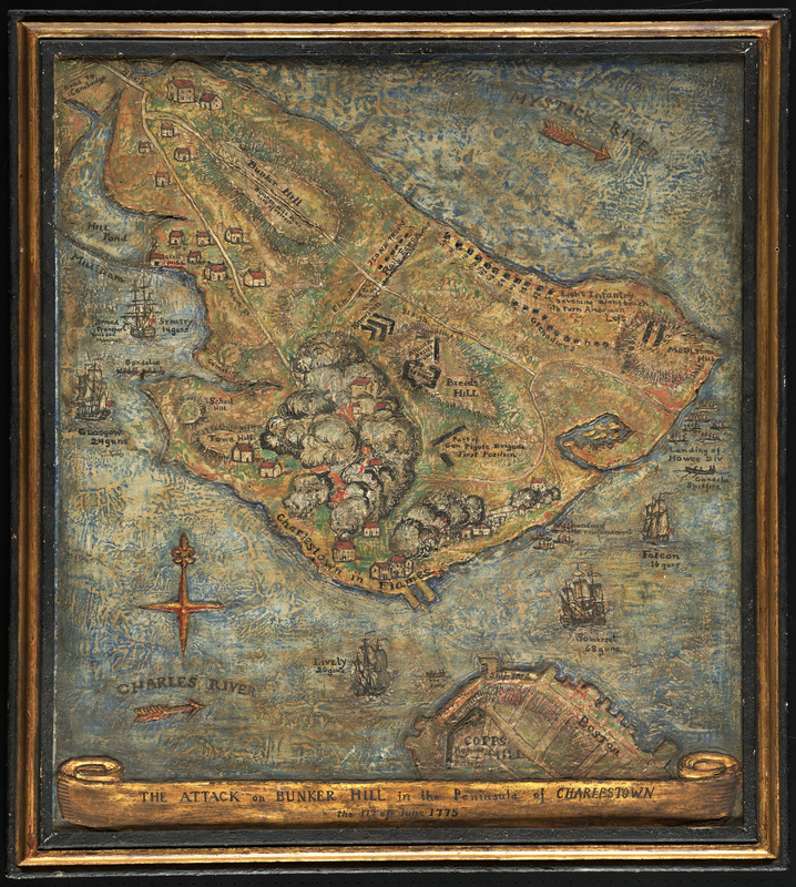
Mildred Giddings Burrage (1890-1983)
The Attack on Bunker Hill in the Peninsula of Charlestown the 17th of June 1775
[Maine, 1926]
Maine-based artist Mildred Burrage created many paintings and drawings throughout her career, which began in the early 20th-century. Burrage studied in both America and Europe, and created numerous impressionist works while staying in France. In the 1920s, she executed several relief-paintings based on historic maps, prints, engravings and photographs. The gesso relief painting displayed here is similar to a vignette illustrated in Sayer and Bennett’s 1775 map “The Seat of War in New England.” Here Burrage has enlarged the battle scene, and used a gesso (white paint mixture) build-up to show relief. She added gold leaf to the piece for added decorative flare.
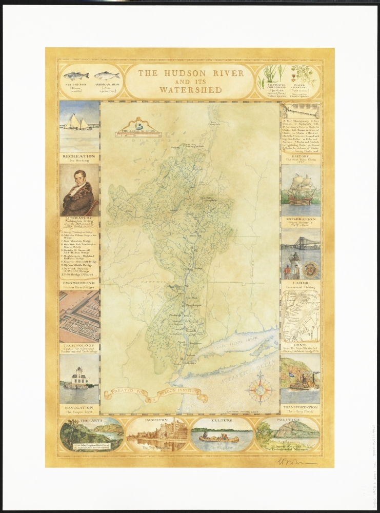
Constance Brown (fl. 1997-)
The Hudson River and Its Watershed
Durham, Connecticut, 2007. Reproduction, 2015.
Gift of Alice C. Hudson.
A map artist for the past twenty years, Connie Brown of Redstone Studios in Connecticut creates unique wall maps for clients that tell stories. Brown’s maps commemorate journeys, special occasions, accomplishments and beloved places, and are painted on canvas. The map of the Hudson River area displayed here, complete with historical and recreational notes, was created for the Beacon Institute for Rivers and Estuaries, and was recently featured in an exhibition at the New York Public Library. Colorful and pictorial in style, it is typical of Brown’s art work.
6. Publications
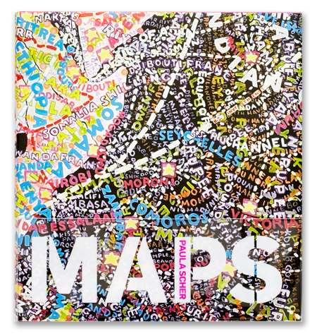
Paula Scher (1948-)
Maps: Paintings and Installations
Princeton, New Jersey, 2011.
Gift of Alice C. Hudson.
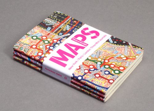
Paula Scher (1948-)
Journals
Gift of Alice C. Hudson.
New-York based graphic designer Paula Scher has been creating art for over three decades. In the 1990s, she began painting maps, as she puts it “to invent my own complicated narrative about the way I see and feel about the world.” Scher’s dense geography combines color and humor, and is representative of the overabundance of information she feels is common in the modern day. The artist describes her maps as “paintings of distortions,” as all maps truly are. Her book of map art is displayed here, along with small journals representing the same.
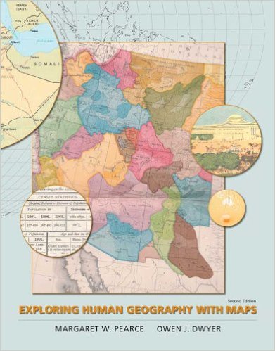
Margaret W. Pearce
Exploring Human Geography with Maps
New York, 2010.
Gift of Alice C. Hudson.
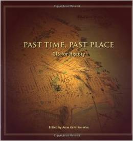
Anne Kelly Knowles, ed. (1957-)
Past Time, Past Place: GIS for History
Redlands, California, 2002.
Gift of Alice C. Hudson.
Margaret Pearce and Anne Knowles, both geography professors and GIS specialists, are leaders in the field of historical geography and digital mapping. Displayed here are books recently published by both women.
7. Women in GIS and the Digital World
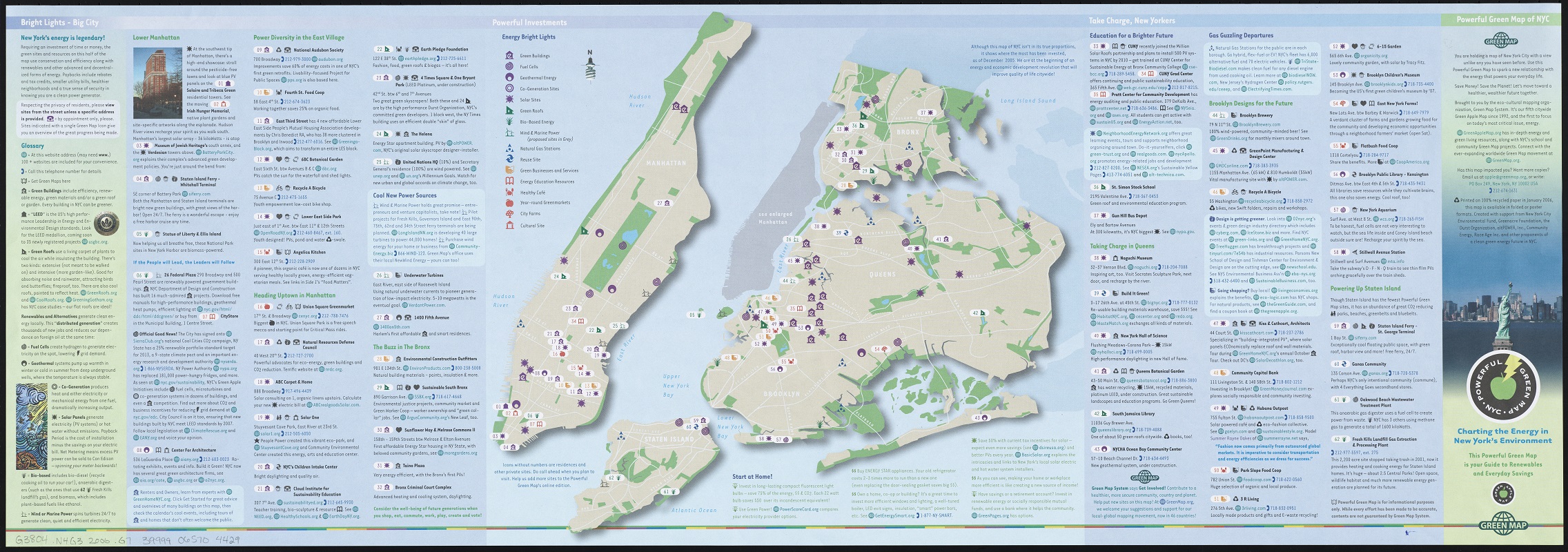
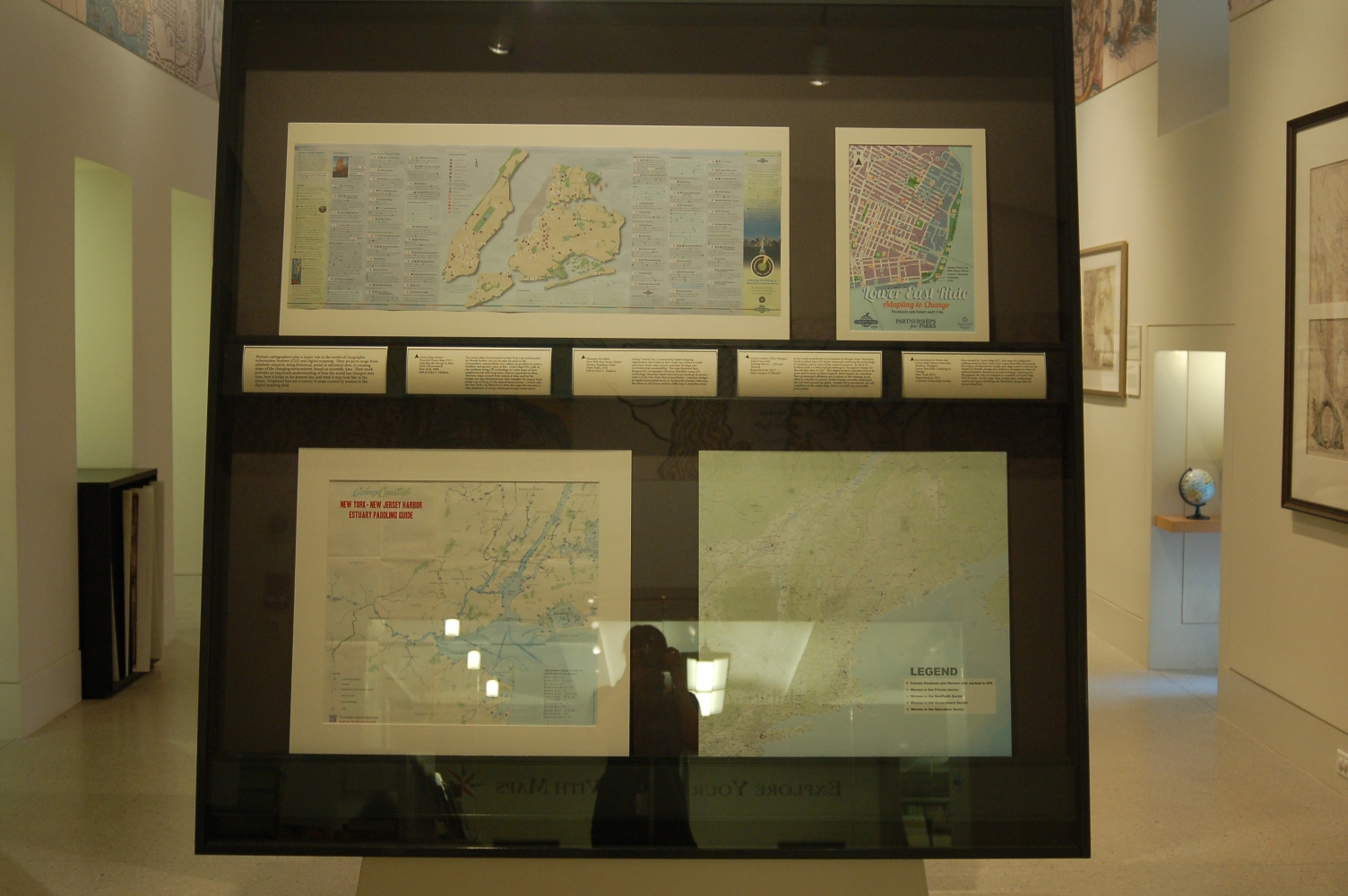
Green Map System; Wendy E. Brawer, Founding Director
Powerful Green Map NYC: Charting the Energy in New York’s Environment
New York, 2006.
Gift of Alice C. Hudson.
The Green Map System based in New York City and founded by Wendy Brawer, has for decades focused on the environment, sustainability and culture, in an effort to create a healthier and greener place to live. Green Map NYC calls on city residents using GIS technology to create maps of their neighborhoods reflecting issues that are important to them. Thematic maps created from statistical data, such as the energy-use map displayed here, help visualize the impact of an urban way of living on the natural environment. Created after the New York City blackout in 2003, this map was intended to raise awareness of energy consumption and conservation.
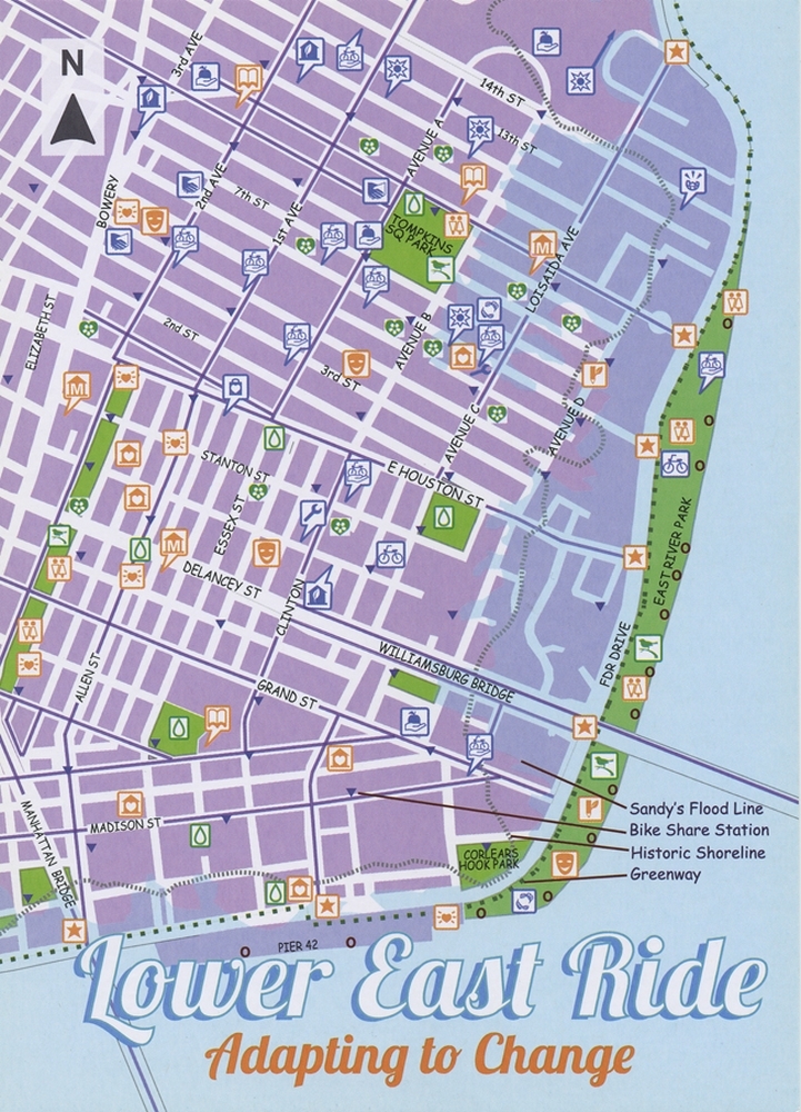
Partnerships for Parks and Green Map System; Maryam Khabazi, Designer
Lower East Ride: Adapting to Change
New York, 2013. Reproduction, 2015.
Courtesy Green Map System.
Also created by Green Map NYC, this map of cycling and walking tours in New York City’s Lower East Side documents the impact of Superstorm Sandy, and urges users to discuss the impact of climate change and resiliency strategies in times of natural disasters. Resources to reduce energy consumption throughout the city are mapped in a number of Green Map NYC’s works. In this map, solar energy sites, composting centers and green buildings are illustrated, along with the storm’s flood line.
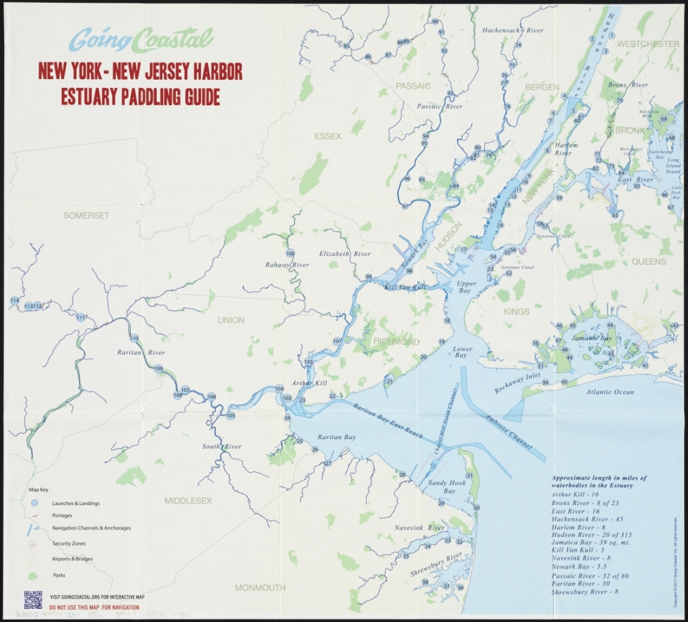
Zhennya Slootskin
New York-New Jersey Harbor Estuary Paddling Guide
[New York], 2011
Gift of Alice C. Hudson.
Going Coastal, Inc., a community-based mapping organization also based in New York City, strives to build awareness about water access, maritime heritage and environmental sustainability. The map displayed here, designed by cartographer Zhennya Slootskin using GIS technology, illustrates kayak launches and landings in estuary waters of the New York-New Jersey harbor. Constant changes to kayak access points occur in the heavily-traveled waterway; therefore, an electronic version of the map is available online.
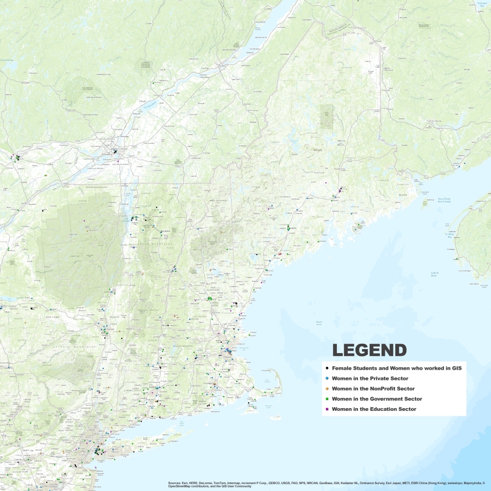
Linda Loubert, PhD; Morgan State University
Making History – GIS and Women
Reproduction, 2015. http://arcg.is/1UE8onH
In her work as professor of economics at Morgan State University, Linda Loubert uses GIS in her classroom, teaching the technology to students, and in most of her research projects. In 2014 Dr. Loubert built a crowd sourced webmap to “recognize women for the role they play in GIS.” This digital project, reproduced here in print and focused on New England, asked women to contribute their professional affiliation and location to the webmap, in an effort to visually document 10,000 women currently working in the GIS field around the globe. Female GIS professionals can still contribute to the online map, which currently has over 6,000 participants.
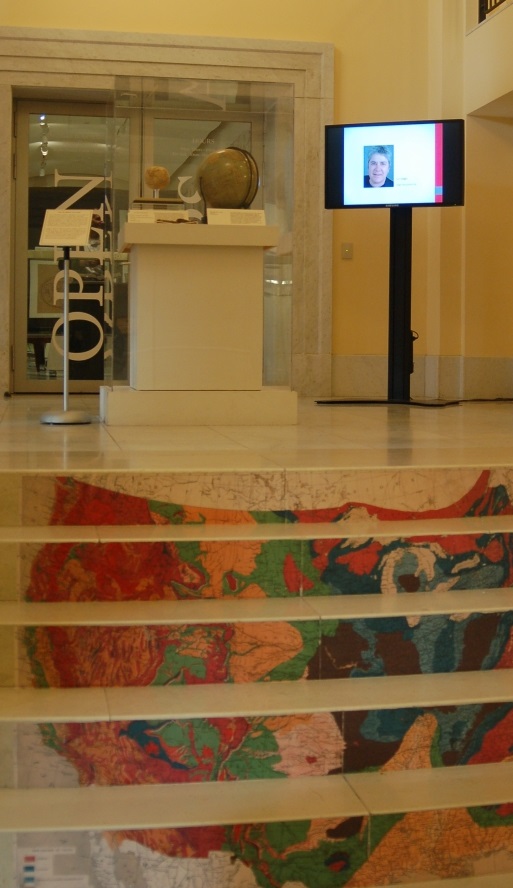
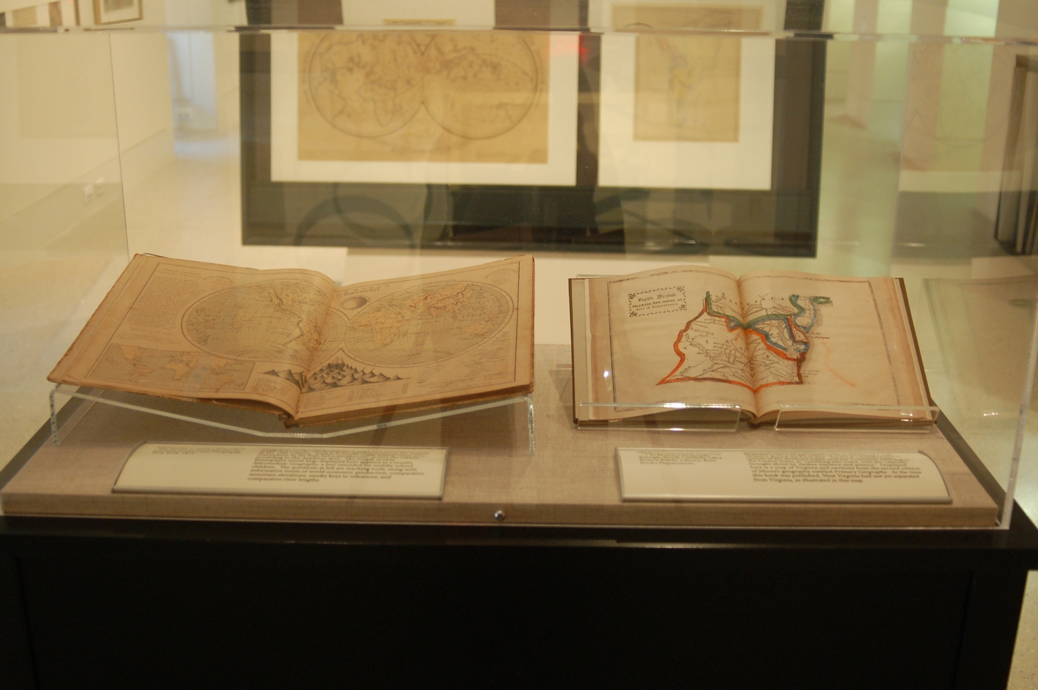
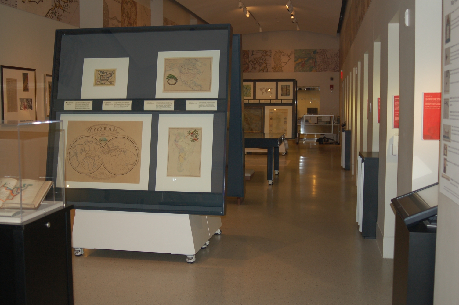
Exhibition Photos
Bibliography
American Sentinel University – Informatics and Technology. Amazing Women in GIS. 20 Oct. 2011. 27 Apr. 2014.
Ancestry.com. 1910 United States Federal Census [database on-line]. Provo, UT, USA: Ancestry.com Operations Inc, 2006. 21 Aug. 2015.
Artists Association of Nantucket. Sutton, Ruth Haviland. 17 Aug 2015. https://www.nantucketarts.org/sutton-ruth-haviland.html
Beem, Edgar Allen. “Mildred Burrage Goes to France.” 25 Apr. 2012. Online posting. Yankee Magazine. 11 Aug 2015. http://www.yankeemagazine.com/art-reviews/mildred-burrage-goes-to-france#_
Buehler, Michael. “A unique relief plan of the Battle of Bunker Hill, by noted Maine artist Mildred Burrage.” Boston Rare Maps dealer description. 2007.
Brown, Connie. About Us. 24 Aug 2015. http://www.redstonsstudios.com/about.php
Carter, Debra. “A Cartographic Career.” Progress & Perspectives: Affirmative Action in Surveying and Mapping. Dec. 1989: 3.
Child, Heather. Decorative Maps. London: Studio Limited, 1956.
“Claire Kiedrowski.” Progress & Perspectives: Affirmative Action in Surveying and Mapping. Jan.-Feb. 1990: 6.
Crosen, Jane. About the Artist. 17 Aug 2015. http://www.mainemapmaker.com/about_the_artist.html
Davis, Jr., O.L. and Serena Rankin Parks. “Confederate School Geographies, I.: Marinda Branson Moore’s Dixie Geography.” Peabody Journal of Education 40.5 (1963) : 265-274. 14 Aug 2015. http://www.jstor.org/stable/1490592
“Dr. Pat Gilmartin, Professionals in Profile.” Progress & Perspectives: Affirmative Action in Surveying and Mapping. July-Aug. 1991: 3-6.
Dymon, Ute J. and Margit Kaye. “Maps and Women.” Meridian. 15 (1999): 5-9.
Eccles, Pippa. “Building Quilts, a Conversation with Architect and Quilter Valerie Goodwin.” Quilting Arts Magazine. Dec. 2009: 2-6.
Felt, Hali. Soundings: The Story of the Remarkable Woman who Mapped the Ocean Floor. New York : Holt, 2012.
Garfield, Emily. Statement/CV. 24 Aug 2015. http://www.emilygarfield.com/statement/
Geographers’ AZ Map Company. About A-Z. 18 Aug 2015. http://www.az.co.uk/?nid=5
Gibson, Anne. The Women’s Atlas of the United States. New York, N.Y. : Facts on File Publications, c1986.
Goodwin, Valerie. About Me. 24 Aug 2015. http://www.quiltsbyvalerie.com/about-me/
“High Praise is Accorded New Map.” The North Adams Evening Transcript. 16 Jan 1930 : 10. Accessed online at: newspapers.com/clip/2113887/shurtelff_mcmillin_map_of_bermuda/ 21 Aug. 2015.
Hudak, Leona M. Early American Women Printers and Publishers 1639-1820. Metuchen, NJ: Scarecrow Press, 1978.
Hudson, Alice. “Pre-Twentieth Century Women Mapmakers.” Progress & Perspectives: Affirmative Action in Surveying and Mapping. Jan.-Feb. 1990; 2-4.
Hudson, Alice. “Research Note: Women in Cartography.” Meridian 15 (1999): 29-30.
Hudson, Alice and Mary Ritzlin. “Preliminary Checklist of Pre-Twentieth Century Women in Cartography – Who are the Groundbreakers?” Cartographica 37.3 (Fall 2000).
Jane Addams Hull-House Museum. About the Museum. 18 Aug 2015. http://www.hullhousemuseum.org/about-the-museum/#
Kuebler-Wolf, Elizabeth. “Train Up a Child in the Way He Should Go: The Image of Idealized Childhood in the Slavery Debate, 1850-1870.” Children and Youth During the Civil War. Ed. James Marten. New York : New York UP, 2012. 29-45.
Nantucket Historical Association. Ruth Haviland Sutton. 17 Aug 2015. http://www.nha.org/digitalexhibits/artistcolony/sutton.htm
National Library of Australia. Digital Collections: Maps. 9 Sept. 2015. http://nla.gov.au/nla.map-rm3869
“Patricia Caldwell Lindgren.” Progress & Perspectives: Affirmative Action in Surveying and Mapping. Mar.-Apr. 1990: 5.
Pentagram. Paula Scher. 1 Sept. 2015. http://www.pentagram.com/partners/#/19/
Petto, Christine M. “Playing the Feminine Card: Women of the Early Modern Map Trade.” Cartographica 4.2 (2009): 67-82.
Portland Museum of Art, Maine. From Portland to Paris: Mildred Burrage’s Years in France. Portland, ME : Trustees of the Portland Museum of Art, 2012.
“Putting Bermuda on the Map.” New York Times. 21 Jan 1930: 120. Accessed online at: ProQuest Historical Newspapers.
Quinn, A.O. “Women in Surveying and Mapping.” American Congress on Surveying and Mapping 4.2 (1944): 37-40.
Residents of Hull-House. Hull-House Maps and Papers. Boston : Thomas Y. Crowell & Co., 1895. C
Rich, Susan. The Cartographer’s Tongue: Poems of the World. Buffalo, N.Y. : White Pine Press, c2000.
Ritzlin, Mary McMichael. “Sweeping the Skies: Some Celestial Ladies of the 17th-19th Centuries.” Meridian. 15 (1999): 11-21.
Ritzlin, Mary McMichael. “The Role of Women in the Development of Cartography.” AB Bookman’s Weekly 9 June 1986.
Ritzlin, Mary McMichael. “Women’s Contributions to North American Cartography: Four Profiles.” Meridian 2 (1989): 5-16.
Schmidt, Jacqueline. About Us. 2007. 24 Aug 2015. http://screechowldesign.com/pages/about-us
Schulten, Susan. Mapping the Nation: History and Cartography in Nineteenth-Century America. Chicago: University of Chicago Press, 2012.
Schweik, Joanne L. “Barbara Buttenfield, Professionals in Profile.” Progress & Perspectives: Affirmative Action in Surveying and Mapping. May-June 1992: 7.
Thrower, Norman J. “Tribute to Helen Margaret Wallis, 1924-1995.” Meridian 15 (1999): 31-32.
Tyner, Judith. “Millie the Mapper and Beyond: The Role of Women in Cartography Since World War II.” Meridian 15 (1999): 23-28.
Tyner, Judith. “The Hidden Cartographers: Women in Mapmaking.” Mercator’s World. 2.6 (1997): 46-51.
Tyner, Judith. “Women in Cartography.” The History of Cartography, vol. 6 part 2. Ed. Mark Monmonier. Chicago: Chicago University Press, 2015.
Van den Hoonaard, Will C. Map Worlds: A History of Women in Cartography. Waterloo, ON, Canada: Wilfrid Laurier Univ. Press, 2013.
Watertown Historical Society. Statement Related to the Hotz Map. 7 Oct 2015. http://www.watertown-ma.gov/DocumentCenter/Home/View/2149
Wilford, John Noble. The Mapmakers. New York : Knopf, 2000.
Credits
Curator
Alice Hudson
Stephanie Cyr
Norman B. Leventhal Map Center Staff
Lauren Chen, Cataloger
Alison Cody, Development Manager
Stephanie Cyr, Assistant Curator of Maps
Ronald Grim, Curator of Maps
Michelle LeBlanc, Director of Education
Janet Spitz, Executive Director
Evan Thornberry, Reference and
Preservation Librarian
Catherine Wood, Office Manager
Boston Public Library Staff
Laura Irmscher
Melina Schuler and BPL Communications Dept.
Facilities Dept.
Graphic Design and Production
Neil Horsky
Andrew Leonard
Digital and Web Services
Tom Blake
Bahadir Kavlakli
Contributors to the Exhibition
Alice C. Hudson
Trustees of the Boston Public Library, Rare Books and Manuscripts Department
Special Thanks
Wendy Brawer, Green Map System
John Cloud, NOAA Central Library
Ian Fowler, Osher Map Library
Candida Lacey and Isabelle Lewis, Myriad Editions
National Geospatial-Intelligence Agency, Historical Research Center and Office of Corporate Communications
Press
Exhibit celebrates 500-year history of women in cartography
The Boston Herald, October 31, 2015
Boston Public Library to showcase role of women in mapmaking
Boston Globe, October 30, 2015