Nantucket

Item Information
- Title:
- Nantucket
- Description:
-
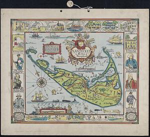
Women in Cartography: Nantucket-based artist Ruth Haviland Sutton produced many prints and oil paintings while residing on the island for nearly forty years. Sutton designed this map of her home in 1946, and it was originally lithographed by her teacher, printmaker George Miller. The map highlights natural features such as plant, animal and bird species and documents favorite island locales, including landmarks and hotels, while the marginal vignettes detail Nantucket’s Native American, agricultural, fishing, early industrial and urban history. This colorful and lively map of the "faraway land," as it was known by native inhabitants, depicts the island as a retreat for wildlife and leisure enthusiasts.
- Creator:
- Sutton, Ruth Haviland, 1898-1960
- Cartographer:
- Sutton, Ruth Haviland, 1898-1960
- Lithographer:
- Miller, George C.
- Name on Item:
-
planned and drawn by Ruth Haviland Sutton ; lithographed by George C. Miller
- Date:
-
[ca. 2010–2015]
- Format:
-
Maps/Atlases
- Location:
-
Boston Public Library
Norman B. Leventhal Map & Education Center - Collection (local):
-
Norman B. Leventhal Map & Education Center Collection
- Subjects:
-
Nantucket Island (Mass.)--Maps
- Places:
-
MassachusettsNantucket (county)Nantucket Island (island)
- Extent:
- 1 map : color ; 32 x 48 cm
- Terms of Use:
-
No known copyright restrictions.
No known restrictions on use.
- Publisher:
-
[Place of publication not identified] :
[publisher not identified]
- Scale:
-
Scale approximately 1:47,000
- Language:
-
English
- Notes:
-
Reproduction.
Insets: Nantucket Town -- Location map.
Decorative border includes text and illustrations.
- Notes (exhibitions):
-
Exhibited: "Women in Cartography: Five Centuries of Accomplishments" organized by the Norman B. Leventhal Map Center at the Boston Public Library, 2015-2016.
- Identifier:
-
06_01_014640
- Barcode:
-
39999065704478