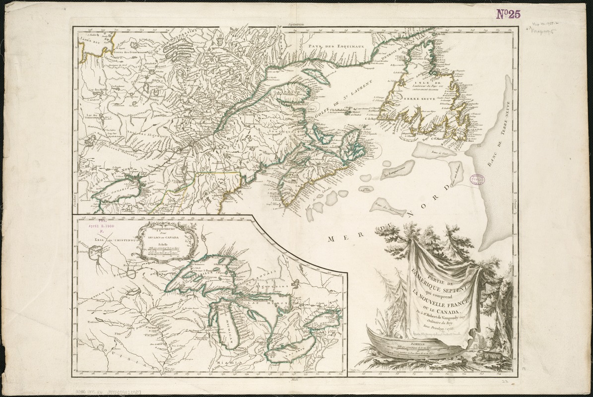
Partie de l'Amérique septent? qui comprend la Nouvelle France ou le Canada
This map is also available in American Revolutionary Geographies Online (ARGO), a collections portal especially built for material relating to the American Revolutionary War Era. Visit ARGO to learn more about this item and explore the historical geography of North America in the late eighteenth century.
Item Information
- Title:
- Partie de l'Amérique septent? qui comprend la Nouvelle France ou le Canada
- Description:
-
This hand-colored map of the Canadian north features a cartouche engraved and signed by C. (Catherine) Haussard. Marie Catherine and her sister Elizabeth were 18th-century Parisian engravers who specialized in the creation of cartouches – the decorative and informative label identifying a map, its author and the subject. The sisters were daughters of noted French engraver Jean-Baptiste Haussard, who trained them in the art of engraving. The cartouche shown here incorporates popular 18th-century symbols of North America – pine trees, a beaver, and a Native American canoe.
- Creator:
- Robert de Vaugondy, Gilles, 1688-1766
- Name on Item:
-
par le Sr. Robert de Vaugondy ; C. Haussard, sculp.
- Date:
-
1755
- Format:
-
Maps/Atlases
- Location:
-
Boston Public Library
Norman B. Leventhal Map & Education Center - Collection (local):
-
Norman B. Leventhal Map & Education Center Collection
- Subjects:
-
Canada--Maps--Early works to 1800
Great Lakes Region (North America)--Maps--Early works to 1800
- Places:
-
Great Lakes Region (area)
Canada
- Extent:
- 1 map : col. ; 48 x 59 cm.
- Terms of Use:
-
No known copyright restrictions.
No known restrictions on use.
- Publisher:
-
Paris? :
[s.n.]
- Scale:
-
Scale ca. 1:4,000,000.
- Language:
-
French
- Notes:
-
Relief shown pictorially.
Inset: Supplement pour les Lacs du Canada.
Cataloging, conservation, and digitization made possible in part by The National Endowment for the Humanities: Exploring the human endeavor.
- Notes (exhibitions):
-
Exhibited: "Women in Cartography: Five Centuries of Accomplishments" organized by the Norman B. Leventhal Map Center at the Boston Public Library, 2015-2016.
- Identifier:
-
06_01_006166
- Call #:
-
G3400 1755 .R6
- Barcode:
-
39999059020907