Nationalities map no. 1 - Polk Street to Twelfth, Halsted Street to Jefferson, Chicago ; Nationalities map no. 2 - Polk Street to Twelfth, Jefferson Street to Beach, Chicago
Item Information
- Title:
- Nationalities map no. 1 - Polk Street to Twelfth, Halsted Street to Jefferson, Chicago ; Nationalities map no. 2 - Polk Street to Twelfth, Jefferson Street to Beach, Chicago
- Title (alt.):
-
Hull House maps
- Description:
-
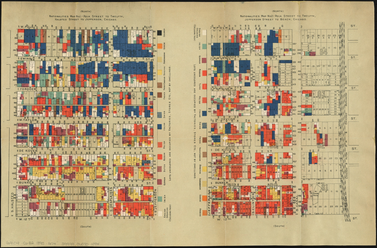
Designed by Agnes Sinclair Holbrook, a Wellesley College graduate and resident of Chicago’s Hull-House, this thematic map of the neighborhood east of the House illustrates the immigrant population living in the area. A female-based social settlement in Chicago’s Near West Side, Hull-House played an important role in social reforms of the late 19th-century, and its residents were responsible for transcribing, interpreting and mapping statistical data for the map displayed here. Part of a set of four, the map is heavily influenced by earlier statistical mapping by Charles Booth’s wage maps of London, first published in 1889. This statistical cartographic presentation foreshadows GIS mapping – using color and statistics to present social facts.
America Transformed: Immigrants often settled in cities like Chicago, where they could find jobs and communities of people from their native countries. In 1889, Jane Addams founded a settlement house in Chicago, called Hull House, offering newcomers childcare as well as classes in English and civics. In this thematic map, based on a survey of the Hull House neighborhood, each color represents a different nation of origin. Italians (dark blue) gathered on some blocks, while others hosted Russian and Polish families (orange). These maps were among the first to illustrate social data as location based.
- Creator:
- Greeley, Samuel Sewell, 1824-1916
- Contributor:
- Hull-House (Chicago, Ill.)
- Contributor:
- Greeley-Carlson Company
- Contributor:
- Thomas Y. Crowell Company
- Date:
-
[1895]
- Format:
-
Maps/Atlases
- Location:
-
Boston Public Library
Norman B. Leventhal Map & Education Center - Collection (local):
-
Norman B. Leventhal Map & Education Center Collection
- Subjects:
-
Ethnology--Illinois--Chicago--Maps
Chicago (Ill.)--Salaries, etc--Maps
Near West Side (Chicago, Ill.)--Maps
Loop (Chicago, Ill.)--Maps
Chicago (Ill.)--Maps
- Places:
-
IllinoisCook (county)Chicago
- Extent:
- 2 maps on 1 sheet : color ; 36 x 54 cm
- Terms of Use:
-
No known copyright restrictions.
No known restrictions on use.
- Publisher:
-
[New York] :
[Thomas Y. Crowell & Co.]
- Scale:
-
Scale approximately 1:1,900
- Language:
-
English
- Notes:
-
Maps issued in: Hull House maps and papers. New York : Thomas Y. Crowell & Co., 1895.
Based on cadastral maps "made from the Greely [that is, Greeley] and Carlsen [that is, Carlson] survey, and generously prepared for the present purpose by Mr. Greely."--Page 8 of accompanying book.
- Notes (date):
-
This date is inferred.
- Notes (exhibitions):
-
Exhibited: "Women in Cartography: Five Centuries of Accomplishments" organized by the Norman B. Leventhal Map Center at the Boston Public Library, 2015-2016.
Exhibited: "America Transformed. Part 2: Homesteads to Modern Cities," organized by the Norman B. Leventhal Map & Education Center at the Boston Public Library, 2019-2020.
- Identifier:
-
06_01_014380
- Call #:
-
G4104.C6E2 1895 .G74
- Barcode:
-
39999065701094