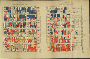
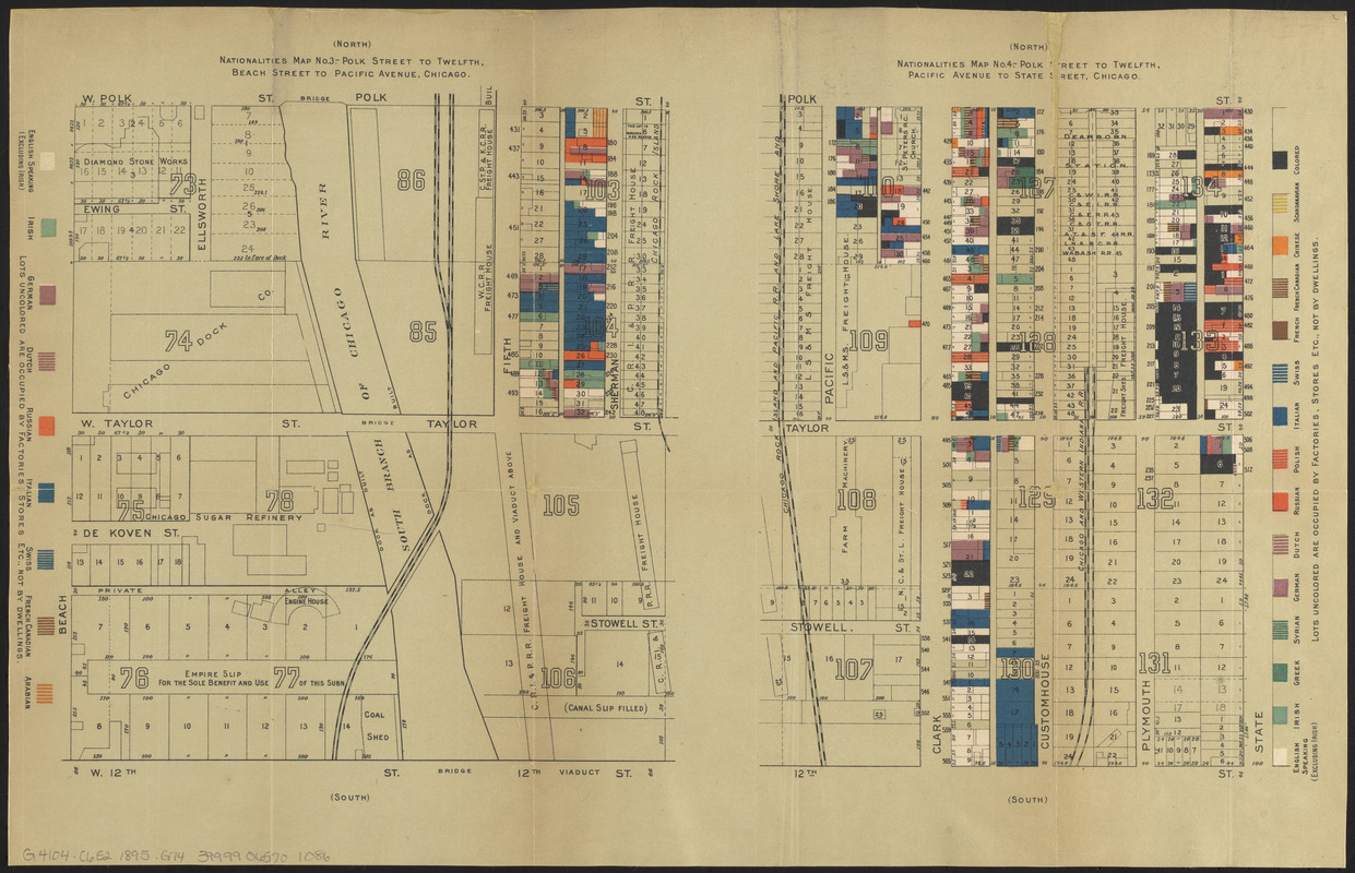
Nationalities map no. 3 - Polk Street to Twelfth, Beach Street to Pacific Avenue, Chicago ; Nationalities map no. 4 - Polk Street to Twelfth, Pacific Avenue to State Street, Chicago
Item Information
- Title:
- Nationalities map no. 3 - Polk Street to Twelfth, Beach Street to Pacific Avenue, Chicago ; Nationalities map no. 4 - Polk Street to Twelfth, Pacific Avenue to State Street, Chicago
- Title (alt.):
-
Hull House maps
- Cartographer:
- Greeley, Samuel S.
- Contributor:
- Hull-House (Chicago, Ill.)
- Contributor:
- Greeley-Carlson Company
- Publisher:
- Thomas Y. Crowell Company
- Date:
-
[1895]
- Format:
-
Maps/Atlases
- Location:
-
Boston Public Library
Norman B. Leventhal Map & Education Center - Collection (local):
-
Norman B. Leventhal Map & Education Center Collection
- Subjects:
-
Ethnology--Illinois--Chicago--Maps
Chicago (Ill.)--Salaries, etc--Maps
Near West Side (Chicago, Ill.)--Maps
Chicago (Ill.)--Maps
- Places:
-
IllinoisCook (county)Chicago
- Extent:
- 2 maps on 1 sheet : color ; sheet 36 x 54 cm
- Terms of Use:
-
No known copyright restrictions.
No known restrictions on use.
- Publisher:
-
[New York] :
[Thomas Y. Crowell & Co.]
- Scale:
-
Scale approximately 1:1,900
- Language:
-
English
- Notes:
-
Maps issued in: Hull House maps and papers. New York : Thomas Y. Crowell & Co., 1895.
Imprint statement from title page of accompanying book.
Based on cadastral maps "made from the Greely [that is, Greeley] and Carlsen [that is, Carlson] survey, and generously prepared for the present purpose by Mr. Greely."--Page 8 of accompanying book.
Indicates nationalities and family weekly income.
- Notes (date):
-
This date is inferred.
- Notes (citation):
-
R.W. Karrow, Checklist of printed maps of the Middle West 4-2332 and 4-2333
- Identifier:
-
06_01_014381
- Call #:
-
G4104.C6E2 1895 .G74
- Barcode:
-
39999065701086