Toggle navigation
LMEC Home
Exhibitions
Georeferencing
Tools for Teachers
Collections
My Favorites
Sign Up / Log In
Search
Search the map portal
Map Collection
Map Collection
Map Sets
Search
Search
Search for
Search In
All Fields
Creator
Title
Subject
Place
Search All Digital Collections
Advanced Search
48 Results
My Search
Start Over
Date
1995
to
1999
Remove constraint Date: <span class='from'>1995</span> to <span class='to'>1999</span>
Filter your Search
Place
North and Central America
42
United States
38
Massachusetts
20
Boston
19
Suffolk (county)
19
New England
5
Plymouth (county)
4
Canada
3
more
Place
»
Topic
Boston (Mass.)--Historical geography--Maps
10
Massachusetts--Maps
4
City planning--Massachusetts--Boston--Maps
3
New England--Maps--Early works to 1800--Facsimiles
3
Allston (Boston, Mass.)--Maps
2
Boston (Mass.)--Maps
2
Brighton (Boston, Mass.)--Maps
2
Coast changes--Massachusetts--Hingham--Maps
2
more
Topic
»
Date
1995
to
1999
[remove]
48
Date range begin
–
Date range end
Current results range from
1900
to
2009
1995
to
1995
28
1996
to
1996
21
1997
to
1997
21
1998
to
1998
18
1999
to
1999
30
Creator
Applied Geographics, Inc.
15
Map Works, Inc.
9
MassGIS (Office : Mass.)
8
Boston Redevelopment Authority
5
Massachusetts Bays Program
5
Massachusetts. Executive Office of Environmental Affairs
5
Massachusetts Coastal Zone Management Office
4
United States. Office of Ocean and Coastal Resource Management
3
more
Creator
»
Format
Maps/Atlases
48
Georeferenced
Yes
4
No
44
Collection
Norman B. Leventhal Map Center Collection
48
Boston and New England Maps
34
Urban Maps
16
Applied Geographics, Inc. Records
15
Boston Redevelopment Authority Collection
5
David Judkins Weaver Papers
5
Available to use
No known restrictions
48
Search Constraints
Sort by relevance
relevance
title
date (asc)
date (desc)
Number of results to display per page
20 per page
10
per page
20
per page
50
per page
100
per page
View results as:
grid view
map view
Search Results
1.
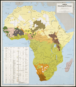
Africa, ethnolinguistic groups
2.
Boston shoreline 1630
3.
Boston shoreline 1795
4.
Boston shoreline 1852
5.
Boston shoreline 1880
6.
Boston shoreline 1916
7.
Boston shoreline 1934
8.
Boston shoreline 1950
9.
Boston shoreline 1995
10.
Boston shoreline composite
11.
Brighton and Allston urban design strategy
12.
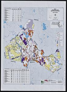
Developable lands and partial constraints : town of Taunton
13.
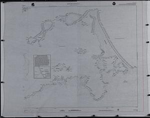
A draught of St. John's harbour : with the soundings
14.
Hingham/Hull Massachusetts : Massachusetts CZM shoreline change analysis project
15.
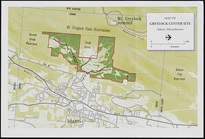
Map of Greylock center site, Adams, Massachusetts
16.
A map of New England and New York
17.
Map of the Back Bay Fens showing the public ways bordering and crossing them and the neighboring newly laid out parts of...
18.
A mapp of New England
19.
Maps of Beverly
20.
Massachusetts coastal towns
‹ Prev
Next ›
1
2
3