Toggle navigation
LMEC Home
Exhibitions
Georeferencing
Tools for Teachers
Collections
My Favorites
Sign Up / Log In
Search
Search the map portal
Map Collection
Map Collection
Map Sets
Search
Search
Search for
Search In
All Fields
Creator
Title
Subject
Place
Search All Digital Collections
Advanced Search
297 Results
My Search
Start Over
1780
Remove constraint 1780
Filter your Search
Place
North and Central America
259
United States
180
Canada
40
New York
34
Charleston (county)
31
Charleston
27
South Carolina
25
New Jersey
19
more
Place
»
Topic
United States--History--Revolution, 1775-1783--Maps
54
Manuscript maps--Early works to 1800
22
Charleston (S.C.)--Maps
11
Charleston (S.C.)--Siege, 1780--Maps
9
Fortification--Newfoundland and Labrador--St. John's--Maps, Manuscript--Early works to 1800
9
Harbors--Newfoundland and Labrador--St. John's--Maps, Manuscript--Early works to 1800
9
Military art and science--Newfoundland and Labrador--St. John's--Maps, Manuscript--Early works to 1800
9
St. John's (N.L.)--Maps, Manuscript--Early works to 1800
9
more
Topic
»
Date
Date range begin
–
Date range end
Current results range from
1711
to
1909
View distribution
Creator
Skinner, Monier
28
Skinner, William, 1700-1780
28
Des Barres, Joseph F. W. (Joseph Frederick Wallet), 1722-1824
25
Faden, William, 1749-1836
16
André, John, 1751-1780
11
Bonne, Rigobert, 1727-1794
8
Carver, Jonathan, 1710-1780
6
Ferguson, Patrick, 1744-1780
6
more
Creator
»
Format
Maps/Atlases
291
Manuscripts
71
Prints
5
Drawings/Illustrations
1
Georeferenced
Yes
7
No
290
Collection
American Revolutionary War-Era Maps
266
Norman B. Leventhal Map & Education Center Collection
66
William L. Clements Library Collection
65
Library of Congress Collection
63
British Library Collection
33
Maritime Charts and Atlases
27
Richard H. Brown Revolutionary War Map Collection at Mount Vernon
26
Boston and New England Maps
13
more
Collection
»
Available to use
Creative Commons license
142
No known restrictions
66
Search Constraints
Sort by relevance
relevance
title
date (asc)
date (desc)
Number of results to display per page
20 per page
10
per page
20
per page
50
per page
100
per page
View results as:
grid view
map view
Search Results
161.
Amérique septentrionale
162.
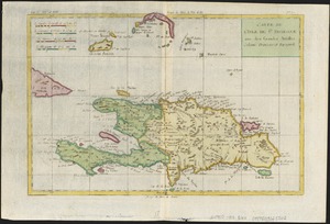
Carte de L'Isle de St. Domingue une des Grandes Antilles, Colonies Francoise et Espagnole
163.
A new and accurate map of the colony of Massachusets Bay, in North America, from a late survey
164.
A new and accurate map of the colony of Massachusets Bay, in North America, from a late survey
165.
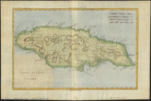
Carte de l'isle de la Jamaïque
166.
[Plan de Gibraltar]
167.
Plan of the siege of York Town in Virginia
168.
Supplement pour les Isles Antilles, extrait des carte Angloises
169.
A plan of the river St. Laurence, from Sillery to the fall of Montmerenci, with the operations of the siege of Quebec; under...
170.
Plan de la rade de la ville du Carénage, isle Ste. Lucie
171.
Southern New York and northern New Jersey
172.
Plan de la baie de Narraganset dans la Nouvelle Angleterre : avec toutes les îles qu'elle renferme parmi lesquelles se...
173.
A map containing part of the Provinces of New York and New Jersey
174.
Plan de Rhodes-Island, et position de l'armée françoise a Newport
175.
Plan of the position which the army under Lt. Genl. Burgoine took at Saratoga on the 10th of September, 1777, and in which it...
176.
A map of the land abt. Red Stone and Fort Pitt
177.
Carte de la Nouvelle Angleterre, Nouvelle Yorck, et Pensilvanie : pour servir à l'Histoire générale des voyages
178.
Barbadoes
179.
Valley of the Hudson River from Fishkill to Teller's Point
180.
Lake Champlain and Lake George, and the country between the Hudson and the lakes on the west, and Connecticut River on the east
‹ Prev
Next ›
1
2
…
5
6
7
8
9
10
11
12
13
14
15


![[Plan de Gibraltar]](https://bpldcassets.blob.core.windows.net/derivatives/images/commonwealth:z603vt83t/image_thumbnail_300.jpg)