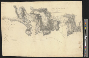
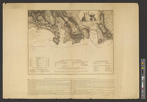
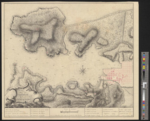
Plan de la rade de la ville du Carénage, isle Ste. Lucie
This map is also available in American Revolutionary Geographies Online (ARGO), a collections portal especially built for material relating to the American Revolutionary War Era. Visit ARGO to learn more about this item and explore the historical geography of North America in the late eighteenth century.
Item Information
- Title:
- Plan de la rade de la ville du Carénage, isle Ste. Lucie
- Creator:
- Peyre, cartographer
- Name on Item:
-
de Peyre
- Date:
-
1784
- Format:
-
Maps/Atlases
- Genre:
-
Manuscript maps
- Location:
- William L. Clements Library
- Collection (local):
-
William L. Clements Library Collection
- Subjects:
-
Saint Lucia--Maps
United States--History--Revolution, 1775-1783--Maps
- Places:
-
Saint Lucia
- Extent:
- 1 ms. map : col. ; 39.5 x 44.7 cm.
- Terms of Use:
-
The University of Michigan Library provides access to these materials for educational and research purposes. These materials may be under copyright. If you decide to use any of these materials, you are responsible for making your own legal assessment and securing any necessary permission. If you have questions about the collection, please contact the William L. Clements Library.
Contact host institution for more information.
- Scale:
-
Scale indeterminable.
- Language:
-
French
- Catalog Record:
-
Catalog record
- Notes:
-
Finished, colored pen and ink map of the port of Carénage (today Castries).
Relief shown pictorially and by hachures. Depths shown by soundings.
Scale in toises.
Includes table of reference.
Shows batteries and locations of vessels grounded during the 1780 hurricane.
- Identifier:
-
895
- Barcode:
-
B6116782