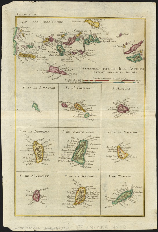
Supplement pour les Isles Antilles, extrait des carte Angloises
This map is also available in American Revolutionary Geographies Online (ARGO), a collections portal especially built for material relating to the American Revolutionary War Era. Visit ARGO to learn more about this item and explore the historical geography of North America in the late eighteenth century.
Item Information
- Title:
- Supplement pour les Isles Antilles, extrait des carte Angloises
- Creator:
- Bonne, Rigobert, 1727-1794
- Date:
-
[1780]
- Format:
-
Maps/Atlases
- Location:
-
Boston Public Library
Norman B. Leventhal Map & Education Center - Collection (local):
-
Norman B. Leventhal Map & Education Center Collection
- Subjects:
-
Antilles, Lesser--Maps--Early works to 1800
Windward Islands (West Indies)--Maps--Early works to 1800
Leeward Islands (West Indies)--Maps--Early works to 1800
- Places:
-
Lesser Antilles (area)
Leeward Islands (area)
Windward Islands (area)
- Extent:
- 1 map : col. ; 32 x 22 cm.
- Terms of Use:
-
No known copyright restrictions.
No known restrictions on use.
- Publisher:
-
Geneve :
J.L. Pellet
- Scale:
-
Scale [ca. 1:1,300,000].
- Language:
-
French
- Notes:
-
Contains 10 inset maps which illustrate the Antilles from the Virgin Islands to Tabago.
Relief shown pictorially.
Appears in Guillaume-Thomas-François Raynal's Atlas de toutes les parties connues du globe terrestre..."Liv.X.XII.XIII et XIV", "No 49." Geneve: J.L. Pellet, 1780.
- Notes (date):
-
This date is inferred.
- Identifier:
-
06_01_006361
- Call #:
-
G5000 1780 .B66
- Barcode:
-
39999059025088

![[Alleen de Caribische Eilanden, vervat in 't groot]](https://bpldcassets.blob.core.windows.net/derivatives/images/commonwealth:st74cw59p/image_thumbnail_300.jpg)
