Toggle navigation
LMEC Home
Exhibitions
Georeferencing
Tools for Teachers
Collections
My Favorites
Sign Up / Log In
Search
Search the map portal
Map Collection
Map Collection
Map Sets
Search
Search
Search for
Search In
All Fields
Creator
Title
Subject
Place
Search All Digital Collections
Advanced Search
1475 Results
My Search
Start Over
Subject
"Boston (Mass.)--Maps"
Remove constraint Subject: "Boston (Mass.)--Maps"
Filter your Search
Place
North and Central America
1,474
United States
1,472
Suffolk (county)
1,391
Boston
1,387
Massachusetts
1,090
Boston Harbor
125
Roxbury
89
Charlestown
71
more
Place
»
Topic
Boston (Mass.)--Maps
741
City planning--Massachusetts--Boston--Maps
407
Urban renewal--Massachusetts--Boston--Maps
245
Real property--Massachusetts--Boston--Maps
243
Landowners--Massachusetts--Boston--Maps
160
Buildings--Massachusetts--Boston--Maps
121
Land use--Massachusetts--Boston--Maps
98
Roxbury (Boston, Mass.)--Maps
88
more
Topic
»
Date
Date range begin
–
Date range end
Current results range from
1689
to
2023
View distribution
Creator
Boston Redevelopment Authority
386
Bromley, George Washington
69
Bromley, Walter Scott
68
G.W. Bromley & Co.
46
Geo. H. Walker & Co
28
Boston (Mass.). Engineering Dept
21
Boynton, George W., d. 1884
21
Sampson, Davenport & Co
21
more
Creator
»
Format
Maps/Atlases
1,472
Manuscripts
50
Drawings/Illustrations
5
Posters
1
Prints
1
Georeferenced
Yes
140
No
1,335
Collection
Boston and New England Maps
1,200
Urban Maps
1,011
Norman B. Leventhal Map & Education Center Collection
994
Boston Redevelopment Authority Collection
449
American Revolutionary War-Era Maps
129
Mapping Boston Collection
52
Massachusetts Real Estate Atlases
38
Maritime Charts and Atlases
28
more
Collection
»
Available to use
No known restrictions
1,292
Creative Commons license
116
Search Constraints
Sort by relevance
relevance
title
date (asc)
date (desc)
Number of results to display per page
20 per page
10
per page
20
per page
50
per page
100
per page
View results as:
grid view
map view
Search Results
1361.
Plan of the action which happen'd 17th. June 1775, at Charles Town, N. America
1362.
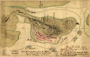
[Rough draft of Charlestown, in water colour]
1363.
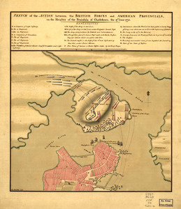
Sketch of the action between the British forces and American provincials, on the heights of the peninsula of Charlestown : the...
1364.
Charlestown urban renewal area r-55 : right of way adjustments
1365.
Cooperative housing : Whitney Street
1366.
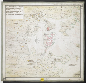
A DRAUGHT of the TOWNS of BOSTON and CHARLES TOWN and the Circumjacent Country shewing the Works thrown up by His MAJESTY'S...
1367.
South Boston urban renewal area r-51 : proposed circulation
1368.
South Boston urban renewal area r-51 : existing circulation
1369.
To the Hone. Jno. Hancock, Esqre. president of ye Continental Congress, this map of the seat of civil war in America, is...
1370.
The Harbor Park system
1371.
Central business district urban renewal area Massachusetts r-82 : disposition parcels
1372.
Central business district urban renewal area Massachusetts r-82 A,B,C : disposition parcels
1373.
Developer's kit : South Cove urban renewal area, project no. Mass. r-92, parcel r-7, residential use
1374.
Illustrative site plan : a proposal for community review South End/Lower Roxbury development policy
1375.
Illustrative site plan : a proposal for community review South End/Lower Roxbury development policy
1376.
Washington Park urban renewal area : report on feasibility of placing utility services underground
1377.
Boston Harbor
1378.
Boston Harbor, 1778
1379.
Charlestown urban renewal area r-42 : GNRP map no. 2
1380.
A city of unequal risks
‹ Prev
Next ›
1
2
…
65
66
67
68
69
70
71
72
73
74
![[Rough draft of Charlestown, in water colour]](https://bpldcassets.blob.core.windows.net/derivatives/images/commonwealth:z603vj49v/image_thumbnail_300.jpg)