Toggle navigation
LMEC Home
Exhibitions
Georeferencing
Tools for Teachers
Collections
My Favorites
Sign Up / Log In
Search
Search the map portal
Map Collection
Map Collection
Map Sets
Search
Search
Search for
Search In
All Fields
Creator
Title
Subject
Place
Search All Digital Collections
Advanced Search
2867 Results
My Search
Start Over
atlas
Remove constraint atlas
Filter your Search
Place
North and Central America
1,663
United States
1,001
Europe
464
Massachusetts
353
Canada
271
South America
191
Asia
190
Suffolk (county)
164
more
Place
»
Topic
Landowners--Massachusetts--Boston--Maps
115
Real property--Massachusetts--Boston--Maps
106
United States--Maps
87
Boston (Mass.)--Maps
64
United States--History--French and Indian War, 1754-1763--Maps
63
Saint Lawrence River--Maps
41
Nautical charts--Early works to 1800
39
North America--Maps--Early works to 1800
36
more
Topic
»
Date
Date range begin
–
Date range end
Current results range from
1482
to
2023
View distribution
Creator
United States. Hydrographic Office
583
Des Barres, Joseph F. W. (Joseph Frederick Wallet), 1722-1824
118
Ptolemy, 2nd cent
100
Bromley, George Washington
99
Bromley, Walter Scott
97
G.W. Bromley & Co.
75
Carey, Mathew, 1760-1839
74
Paullin, Charles Oscar, 1868 or 1869-1944
70
more
Creator
»
Format
Maps/Atlases
2,851
Manuscripts
58
Books
37
Prints
8
Documents
5
Drawings/Illustrations
1
Georeferenced
Yes
142
No
2,725
Collection
Norman B. Leventhal Map & Education Center Collection
2,410
Maritime Charts and Atlases
1,167
American Revolutionary War-Era Maps
504
Boston and New England Maps
382
Urban Maps
255
Massachusetts Real Estate Atlases
144
William L. Clements Library Collection
92
Mapping Boston Collection
61
more
Collection
»
Available to use
No known restrictions
2,316
Creative Commons license
158
Search Constraints
Sort by relevance
relevance
title
date (asc)
date (desc)
Number of results to display per page
20 per page
10
per page
20
per page
50
per page
100
per page
View results as:
grid view
map view
Search Results
1241.
Heathers, improved chart of the Bermudas, drawn from the best surveys
1242.
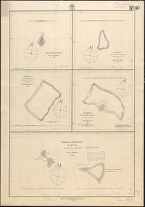
Hereheretue or St. Pablo, Paumotu Group ; Nukutipipi or Margaret Island, Paumotu Group ; Anu-Anuraro, Heretua or Archangel of...
1243.
Horta and Pim Bays, Fayal Id. Azores ; Fayal Channel, Azores
1244.
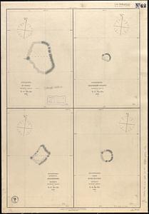
Hudsons Island ; Maraki or Matthews Island, Kingsmill Group ; Maiana or Halls Island, Kingsmill Group ; Apamama or Hoppers...
1245.
Hudsons Island ; Maraki or Matthews Island, Kingsmill Group ; Maiana or Halls Island, Kingsmill Group ; Apamama or Hoppers...
1246.
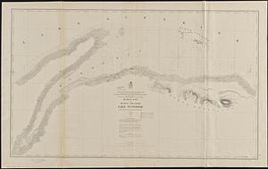
Huron Bay and Huron Islands, Lake Superior
1247.
Hydrographische kaart der vaarwaters van het Haringvliet, Krammer, Volkrak & Hollandschdiep : trigonometriesch opgenomen en in...
1248.
Indian Ocean : ports on the western coast of Madagascar : from British surveys, corrected to 1874
1249.
Indian Ocean
1250.
Indian Ocean : ports on the east coast of Madagascar : from British and French surveys, corrected to 1874
1251.
The Indian Ocean : compiled from the latest authorities, 1880
1252.
Indian Ocean, Gulf of Aden--North coast, Aden and adjacent bays : republished from the Brit. Admty chart no. 7, corrected to 1873
1253.
Indian Ocean, harbors of Kerguelen Island : republication of Brit. Admty chart no. 800
1254.
Indian Ocean, Kerguelen Island, Royal Sound ; Royal Sound, Island Harbor
1255.
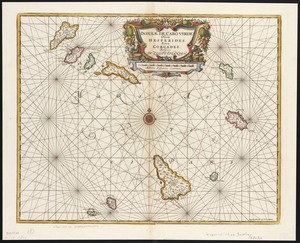
Insulae de Cabo Verde, Olim Hesperides, sive Gorgades : Belgice de zoute eylanden
1256.
Island and harbours of Mbenga, south side of Viti Levu, Feejee Group ; Rewa-Roads, south side of Viti Levu
1257.
The island of Jamaica
1258.
Island of Moala, Feejee Group ; Island of Totoia, Feejee Group ; Island of Matuku, Feejee Group
1259.
Island of Ovolau, Feejee Group
1260.
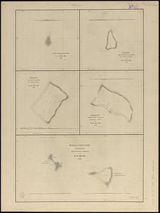
Island of Savaii, Samoan Group
‹ Prev
Next ›
1
2
…
59
60
61
62
63
64
65
66
67
…
143
144